"Snow's Pathfinder railway guide, week ending Saturday, July 9, 1864. Supplement.", Covers also part of eastern New York., Includes advertisements in bottom right corner., On verso: train timetables, post office hours,, and Shows finished and unfinished railways.
Includes statistical charts: Population of the United States (by state and territory, 1790-1860) -- Ratio of slaves to total population -- Positions of forts., Insets: Map of the great railroad routes fr, Prime meridian: Greenwich., and Relief shown by hachures.
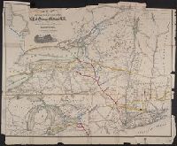
Map of New York State and vicinity showing drainage, canals, cities and towns, and named railroads. January 1st, 1869 edition has "W. B. Gilbert, Chief Engineer."
Description:
Description derived from published bibliography., Imperfect: mutilated with loss of text. Ms. markings., and Inset: [Great Lakes] 18 X 36 cm.
Subject (Name):
Gilbert, William B, New York & Oswego Midland Railroad, and New York & Oswego Midland Railroad--Maps
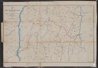
Covers areas of N.Y., Conn., and Mass. surrounding their intersection. and Includes ancillary "Profile of the Dutchess and Columbia and the proposed Connecticut Western Rail Road."
Publisher:
H.H. Lloyd & Co.'s Map Establishment,
Subject (Geographic):
Connecticut--Maps, Massachusetts--Maps, and New York (State)--Maps
Subject (Name):
Connecticut Western Railroad Co.--Maps and Dutchess and Columbia Railroad Co.--Maps
Subject (Topic):
Railroads--Connecticut--Maps, Railroads--Massachusetts--Maps, and Railroads--New York (State)--Maps
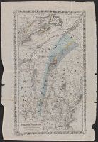
"Entered according to Act of Congress in the year 1865 by J.H. Colton ...", Inset: Map showing the distribution of the gold bearing rocks of eastern America / by C.H. Hitchcock., Relief shown by hachures., and Shows selected geological features of Vermont and so