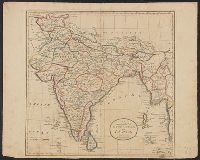
Appears in the Carey's General atlas, improved and enlarged. 1817., Hand col. Mounted on linen. Sheet measures 43 x 53 cm., In top right margin: 53., Name burnished out below title, probably J.T. Scott, sculp., and Relief shown pictorially.
Publisher:
M. Carey & Son,
Subject (Geographic):
India--Maps and South Asia--Maps
Subject (Name):
Carey, Mathew, 1760-1839. Carey's general atlas, improved and enlarged and M. Carey & Sons
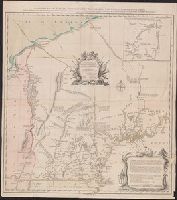
Appears in Thomas Jefferys' A general topography of North America. 1768. no. 22, plates 30-31. and Includes inscription to "Charles Townshend, His Majesty's Secretary at War," text, and inset "A general map of the River St. Lawrence above Montreal to Lake Ont
1 of 2 copies of 1st state (see also 762 1761). For 2nd state see 762 1784B., 1st state (McCorkle 322, Wheat and Brun 39)., Appears in Jefferys's General Topography of North America (London 1768)., and In cartouche: "Dedicated to the Right Honourable Charles Tow
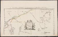
Particular map of Baffin and Hudson's Bay and Passage by land to California discover'd by Father Eusebius Francis Kino ...
Description:
"Longit. w. from Ferro.", Hand colored., Includes historical notes, notes on territorial claims, and insets of "A particular map of Baffin and Hudson's Bay" and "The passage by land to California.", and Relief shown pictorially.
Publisher:
Printed for Robert Sayer, no 53 Fleet Street ...,
Subject (Geographic):
North America--Maps--Early works to 1800
Subject (Name):
Gibson, J. (John), active 1750-1792 and Sayer, Robert, 1725-1794
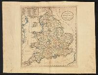
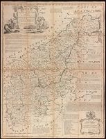
Dedication in decorative cartouche: To the Right Honble. George Montagu Earl of Halifax, Lord Lieutenant & Custos Rotulorum for the County of Northampton & First Commissioner of the Plantation Office. This map is humbly dedicated by His Lordship's obedt. servant Eman. Bowen., Dissected and mounted on linen., Includes text on some towns, their manufactures and natural products, Earls of Northampton, and seats of the Nobility., Plate 26 from: The large English atlas, or, A new set of maps of all the counties in England and Wales / Emanuel Bowen. London: Printed and sold by Robert Wilkinson, at No. 58, in Cornhill, successor to Mr John Bowles, deceased, [1785]., Prime meridian: London., and Relief shown pictorially.
Publisher:
Printed for Robt. Wilkinson, Cornhill & Robt. Sayer in Fleet Street, Carrington Bowles in St. Pauls Church Yard,
Subject (Geographic):
Northamptonshire (England)--Maps--Early works to 1800.
Subject (Name):
Bowen, Emanuel, 1693 or 1694-1767. Large English atlas, or, A new set of maps of all the counties in England and Wales., Bowles, Carington, 1724-1793, Sayer, Robert, 1725-1794, and Wilkinson, Robert, -approximately 1825