Search
You Searched For
Search Results
- Published / Created:
- 1760
- Call Number:
- 771fcm R297 1760
- Container / Volume:
- BRBL_00714
- Image Count:
- 1
- Resource Type:
- Maps, Atlases & Globes
- Found in:
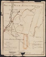
- Beinecke Rare Book and Manuscript Library > A Map Claverack and Parts adjacent shewing the Claim of John Van Renselaer Esqr. The construction set up on the part of the crown, in the late action of intrustion. Done at New York, 9. Nov. 1760.
- Published / Created:
- 1768
- Call Number:
- 771 Al13 1768
- Container / Volume:
- BRBL_00713
- Image Count:
- 2
- Resource Type:
- Maps, Atlases & Globes
- Found in:
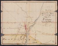
- Beinecke Rare Book and Manuscript Library > A Map of the Lands Adjoining the Partition Line between Countys of Albany & Ulster Done of New York, 1768, Will Cockburn.
- Published / Created:
- 1765
- Call Number:
- 771 Al13 1765
- Container / Volume:
- BRBL_00713
- Image Count:
- 2
- Resource Type:
- Maps, Atlases & Globes
- Found in:
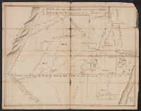
- Beinecke Rare Book and Manuscript Library > A Map of the Lands on the Southside of the County of Albany between the Blue Mountains and the Sawkill. Surred in the month of Oct. 1765, by Will Cockburn.
- Published / Created:
- [1764?]
- Call Number:
- 76cea 1764
- Container / Volume:
- BRBL_00446
- Image Count:
- 1
- Resource Type:
- Maps, Atlases & Globes
- Found in:
- Beinecke Rare Book and Manuscript Library > A New and Correct Chart of the Sea Coast of New-England, from Cape Codd to Casco Bay. Lately Surbey'd by Capt. Henry Barnsley.
- Published / Created:
- 1764
- Call Number:
- 771ad An71 1764
- Container / Volume:
- BRBL_00714
- Image Count:
- 1
- Resource Type:
- Maps, Atlases & Globes
- Found in:
- Beinecke Rare Book and Manuscript Library > A coppy of the plan of the Provincial Pattent surveyed. by Archibald Campbell and protraited by a scale of 30: chains to an inch, December 14, 1764.
- Published / Created:
- 1766
- Call Number:
- 786gmg P838 1766
- Container / Volume:
- BRBL_00516
- Image Count:
- 1
- Resource Type:
- Maps, Atlases & Globes
- Found in:
- Beinecke Rare Book and Manuscript Library > A draught of Port Royal Harbour in South Carolina with the marks for going in. By JAmes Cook.
- Published / Created:
- Decemr. 1766.
- Call Number:
- 732cea 1766
- Container / Volume:
- BRBL_00377
- Image Count:
- 1
- Resource Type:
- Maps, Atlases & Globes
- Found in:
- Beinecke Rare Book and Manuscript Library > A draught of the harbour of Hallifax, and the adjacent coast in Nova Scotia / survey'd by order of Commodore Spry by James Cook, when master of His Majesty's ship the Mars ; Emanl. Bowen, sculpt.
- Published / Created:
- 1768
- Call Number:
- 755FD 1768
- Container / Volume:
- BRBL_00442
- Image Count:
- 1
- Resource Type:
- Maps, Atlases & Globes
- Found in:
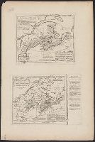
- Beinecke Rare Book and Manuscript Library > A map ... of the English rights relative to the Ancient limits of Acadia ...
- Creator:
- Delarochette, L. (Louis), 1731-1802
- Published / Created:
- [1769]
- Call Number:
- 40 1777
- Container / Volume:
- BRBL_00198
- Image Count:
- 1
- Resource Type:
- Maps, Atlases & Globes
- Found in:
- Beinecke Rare Book and Manuscript Library > A map of Italy / by Mr. Palairet with improvements & additions from the best authorities by L. Delarochette ; Tho Kitchin sculpt.
- Creator:
- Delarochette, L. (Louis), 1731-1802
- Published / Created:
- 1765
- Call Number:
- 71 1765
- Container / Volume:
- BRBL_00364
- Image Count:
- 1
- Resource Type:
- Maps, Atlases & Globes
- Found in:
- Beinecke Rare Book and Manuscript Library > A map of North America / by J. Palairet, with considerable alterations & improvements from d'Anville, Mitchell & Bellin, by L. Delarochette.