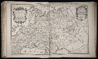
Dominion of the Czar of Russia Alba or Great Duke of Moscovia ... described by Sanson, corrected and amended by William Berry, Moscovia, and Russia Alba
Description:
Bar scales in Italian miles, common leagues of France, common leagues of Germany, common leagues of Sweden or Great leagues of Germany, common leagues of Poland, verstes or common leagues of Moscovia, and leagues that are one hours travelling., Dedicated To the most serene and most sacred majesty Charles II ... by William Berry., Ferro meridian., No. 40 of 69 maps bound together in composite atlas., Relief shown pictorially., and Scale [ca. 1:6 000 000].
Publisher:
Sold by William Berry at the sign of the Globe between Charing-Cross and White-Hall
Scandinavia and its confines in which are the Kingdom's of Sweden, Denmark, and Norway divided into their principall provinces viz under the crown of Sweden ... described by Sanson, corrected and amended by Wilm. Berry
Description:
Bar scales in Italian miles, common leagues of France, common leagues of Germany & Denmark, Swedish or great German leagues, common leagues of Norway, verstes or leagues of Moscovy, and leagues of one hours traveling., Dedicated To the most serene and most sacred majesty Charles II ... by William Berry., Ferro meridian., No. 41 of 69 maps bound together in composite atlas., Relief shown pictorially., and Scale [ca. 1:4 000 000].
Publisher:
Sold by William Berry at ye sign of ye Globe between Charing-Cross and White-Hall
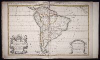
South America divided into its pricipall parts, viz. the Firm-land, Peru, Chili ... described by Sanson, corrected and amended by William Berry
Description:
Bar scales given in Italian miles, common leagues of France, common leagues of Spain, common leagues of Germany, and common English miles., Dedicated to Charles II by William Berry., No. 69 of 69 maps bound together in composite atlas., Prime meridian: Ferro., Relief shown pictorially., and Scale [ca. 1:16 000 000].
Publisher:
Sold by William Berry at the sign of the Globe between Charing-Cross and White-Hall
Spain distinguisht into all its kingdoms, principalities & c., that is to say under the dominion of the Catholick king viz. the kingdom of Castile, Leon, Galicia ... described by Sanson, corrected and amended by William Berry
Description:
Bar scales given in Italian miles, common leagues of France, common leagues of Spain, common leagues of Germany, and English miles., Dedicated To the most serene and most sacred majesty of Charles II ... by William Berry, and dated 1682., Includes coat of arms and decorative cartouche containing dedication., No. 10 of 69 maps bound together in composite atlas., Prime meridian: Ferro., Relief shown pictorially., Scale [ca. 1:2 100 000]., and With inset map of Cadiz Bay.
Publisher:
Sold by William Berry at the signe of the Globe between Chering Cross and White Hall
Subject (Geographic):
Iberian Peninsula --Maps --Early works to 1800 and Spain --Maps --Early works to 1800
Bar scales in Milliaria Germanica communia 15 in uno gradu, Milliaria Gallica magna, sive horae itineris, and milliaria Italica magna 60 in uno gradu., No. 19 of 69 maps bound together in composite atlas., Relief shown pictorially., and Scale [ca. 1:860 000].
Publisher:
[Frederik de Wit?]
Subject (Geographic):
Tuscany (Grand Duchy) --Maps --Early works to 1800
Bar scales given in milliaria Germanica communia and milliaria Gallica communia., Ferro meridian., No. 54 of 69 maps bound together in composite atlas., Relief shown pictorially., and Scale [ca 1:1 330 000].
Bar scales in Mill. Germanica Comm 15 in uno gradu and Mill. Gallica et Livonica quae horae itineris., Ferro meridian., No. 38 of 69 maps bound together in composite atlas., Relief shown pictorially., and Scale [ca. 1:910 000].
Subject (Geographic):
Estonia --Maps --Early works to 1800 and Latvia --Maps --Early works to 1800
Mortier, David Mortier, Pierre Sanson, Nicolas, 1600-1667, creator
Published / Created:
[1710]
Call Number:
1973 Folio 10
Image Count:
1
Resource Type:
Maps, Atlases & Globes
Alternative Title:
Premiere carte de la Meuse avec les pais, duchez et comtez voisins and Teatre de la guerre en Flandre et Brabant
Description:
Alternate title in upper margin: Premiere carte de la Meuse avec les pais, duchez et comtez voisins., Does not show troop positions or other military locations., Ferro meridian., Imperfect: western sheet (with title cartouche) wanting. Part of eastern map (inset of Arras/Cambrai region) pasted over correction[?]., Includes inset of Arras/Cambrai region and color illustration of battles at upper left and lower right., No. 47 of 69 maps bound together in composite atlas., Originally printed on 4 sheets., Presentee a son altesse Monseigneur le Duc & Comte [sic] de Marlborough, Marquis de Blandford, &c. &c. &c., par son tres-humble et tres-obeissant serviteur, Pierre Mortier, libraire a Amsterdam., Relief shown pictorially., and Scale [ca. 1:250 000].
Publisher:
Apud Petrum Mortier, et se vend a Londres chez David Mortier
Subject (Topic):
Spanish Succession, War of, 1701-1714 --Maps --Early works to 1800