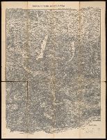
Touristen-karten im Massstabe von 1:129,600 and Umgebung von Gmunden, Ischl, Hallstadt, Aufsee
Description:
Imperfect: all sheets but sheet 2 wanting. "Uebersichtsblatt zu R. Maschek's Touristenkarte" pasted on verso., Relief shown by hachures., and Title from panel pasted on verso.
Bar scales given in "mill. Germanica," "mill. Gallica," and "mill. Italica.", Includes illustration "Die Vestung Kofel.", Ms. no. on verso: LII. Sheet measures 53 x 65.4 cm., and Relief shown pictorially.
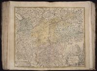
[Atlas factice of 50 maps, primarily by Johann Baptist Homann and/or issued by the Homann Erben
Image Count:
1
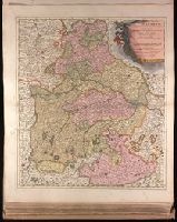
Description:
Bar scales given in "mill. Germanica," "mill. Gallica," and "mill. Italica.", Includes illustration "Die Vestung Kofel.", Relief shown pictorially., and Sheet measures 54.3 x 64.5 cm. No. 30 of 50 maps bound together.
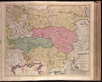
"Cum privilegio.", Appears in Justus Danckerts's Atlas editions after 1696; see Koeman, C. Atlantes Neerlandici, vol. III, Dan 3, Dan 4., Bar scales given in "milliaria Garmanica communia" and "milliaria Gallica"., Imperfect: slightly stained on recto and verso, with no loss of text. Backed with paper. Ms. no. in upper right corner: 26. Sheet measures 53.7 x 62.6 cm. No. 26 of 87 maps bound together., Prime meridian: Ferro., Relief shown pictorially., Watermark., and With inset map "Comit. Tirolis".
Backed with paper. Ms. no. "27" in upper right-hand corner. Sheet measures 52.7 x 53.7 cm. No. 27 of 87 maps bound together., Bar scales given in "milliaria Germanica" and "mill. Gallica"., Prime meridian: Ferro., and Relief shown pictorially.