Search
You Searched For
Search Results
- Creator:
- Chabert, Joseph Bernard, marquis de, 1724-1805
- Published / Created:
- 25th, March 1775.
- Call Number:
- 72cea 1775
- Container / Volume:
- BRBL_00688
- Image Count:
- 1
- Resource Type:
- Maps, Atlases & Globes
- Found in:
- Beinecke Rare Book and Manuscript Library > A chart of the Banks of Newfoundland / drawn from a great number of hydrographical surveys, chiefly from those of Chabert, Cook, and Fleurieu, connected and ascertained by astronomical observations.
- Creator:
- Chabert, Joseph Bernard, marquis de, 1724-1805
- Published / Created:
- 25th, March 1775.
- Call Number:
- 72cea 1775
- Container / Volume:
- BRBL_00373
- Image Count:
- 1
- Resource Type:
- Maps, Atlases & Globes
- Found in:
- Beinecke Rare Book and Manuscript Library > A chart of the Banks of Newfoundland / drawn from a great number of hydrographical surveys, chiefly from those of Chabert, Cook, and Fleurieu, connected and ascertained by astronomical observations.
- Creator:
- Lucas, Fielding, 1781-1854
Warr, John, b. ca. 1798
Warr, William W
- Published / Created:
- [1862], c1852
- Call Number:
- 21cea 1862
- Image Count:
- 1
- Resource Type:
- Maps, Atlases & Globes
- Found in:
- Beinecke Rare Book and Manuscript Library > A chart of the Chesapeake and Delaware Bays / compiled and published by Fielding Lucas.
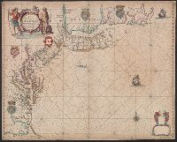
- Creator:
- Jefferys, Thomas, -1771
- Published / Created:
- 25th March, 1775.
- Call Number:
- 7345cea 1775A
- Container / Volume:
- BRBL_00689
- Image Count:
- 1
- Resource Type:
- Maps, Atlases & Globes
- Found in:
- Beinecke Rare Book and Manuscript Library > A chart of the Gulf of St. Laurence [cartographic material] : composed from a great number of actual surveys and other materials, regulated and connected by astronomical observations.
- Creator:
- Delarochette, L. (Louis), 1731-1802
- Published / Created:
- June 28th, 1780.
- Call Number:
- 39cea 1780
- Container / Volume:
- BRBL_00192
- Image Count:
- 1
- Resource Type:
- Maps, Atlases & Globes
- Found in:
- Beinecke Rare Book and Manuscript Library > A chart of the coasts of Spain and Portugal, with the Balearic Islands, and part of the coast of Barbary / by L.S. De la Rochette.
- Creator:
- Morris, Charles, fl. 1749, cartographer
- Published / Created:
- 1759?]
- Call Number:
- 732cea H13 1759
- Container / Volume:
- BRBL_00378
- Image Count:
- 1
- Resource Type:
- Maps, Atlases & Globes
- Found in:
- Beinecke Rare Book and Manuscript Library > A chart of the harbour of Halifax, in Nova Scotia : with Jebucto Bay and Cape Sambrô, also the islands, ledges of rocks, shoals & soundings / survey'd, by order of His Excellency Brigadier General Lawrence, Governour of the Province of Nova Scotia, by Ch
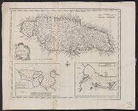
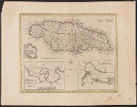
- Creator:
- Lodge, John, -1796
- Published / Created:
- 31 Augst. 1780.
- Call Number:
- 8555 1780A
- Container / Volume:
- BRBL_00695
- Image Count:
- 1
- Resource Type:
- Maps, Atlases & Globes
- Found in:
- Beinecke Rare Book and Manuscript Library > A chart of the island of Jamaica [cartographic material] : with its bays, harbours, rocks, soundings, &c. / Jno. Lodge, sculp.
- Creator:
- Seller, John, fl. 1658-1698
- Published / Created:
- 1675?]
- Call Number:
- 755cea 1675
- Container / Volume:
- BRBL_00441
- Image Count:
- 1
- Resource Type:
- Maps, Atlases & Globes
- Found in:
- Beinecke Rare Book and Manuscript Library > A chart of the sea coasts of New-England, New-Jarsey, Virginia, Maryland and Carolina : from C. Cod to C. Hatteras / by John Seller, hydrogr. to the King ; Iames Clerk sculpsit.
- Creator:
- Seller, John, fl. 1658-1698
- Published / Created:
- [1671?]
- Call Number:
- 319cea 1671
- Container / Volume:
- BRBL_00042
- Image Count:
- 1
- Resource Type:
- Maps, Atlases & Globes
- Found in:
- Beinecke Rare Book and Manuscript Library > A chart of ye narrow seas / newly corrected by John Seller, hydrographer to the kings most excellent majestie.
- Creator:
- Hawkesworth, John, 1715?-1773
- Published / Created:
- [1773]
- Call Number:
- 282 1767
- Collection Title:
- Account of the voyages undertaken by the order of His present Majesty for making discoveries in the
- Container / Volume:
- BRBL_00683
- Image Count:
- 1
- Resource Type:
- Maps, Atlases & Globes
- Found in:
- Beinecke Rare Book and Manuscript Library > A dangerous shoal seen Septr. the 28, 1767 [cartographic material] : The south end of Mindanao ; Joseph Freewills Islands.
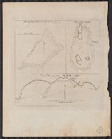
- Published / Created:
- ca. 1705]
- Call Number:
- 732cea C413 1705
- Container / Volume:
- BRBL_00709
- Image Count:
- 1
- Resource Type:
- Maps, Atlases & Globes
- Found in:
- Beinecke Rare Book and Manuscript Library > A draught of Southacks Bay in America [cartographic material].
- Creator:
- Delarochette, L. (Louis), 1731-1802
- Published / Created:
- September 22d, 1796.
- Call Number:
- 85 1796A
- Container / Volume:
- BRBL_00693
- Image Count:
- 1
- Resource Type:
- Maps, Atlases & Globes
- Found in:
- Beinecke Rare Book and Manuscript Library > A general chart of the West India Islands with the adjacent coasts of the Spanish continent [cartographic material] / by L.S. de la Rochette.
- Creator:
- Jefferys, Thomas, d. 1771
- Published / Created:
- 10th, May 1775.
- Call Number:
- 72 1775
- Container / Volume:
- BRBL_00688
- Image Count:
- 1
- Resource Type:
- Maps, Atlases & Globes
- Found in:
- Beinecke Rare Book and Manuscript Library > A general chart of the island of Newfoundland with the rocks & soundings / [cartographic material] / drawn from surveys taken by order of the Right Honourable the Lords Commissioners of the Admiralty by James Cook and Michael Lane, surveyors, and others.
- Creator:
- Jefferys, Thomas, d. 1771
- Published / Created:
- April 6, 1775.
- Call Number:
- 7311 1775
- Container / Volume:
- BRBL_00688
- Image Count:
- 1
- Resource Type:
- Maps, Atlases & Globes
- Found in:
- Beinecke Rare Book and Manuscript Library > A map of the island of St. John in the Gulf of St. Laurence [cartographic material] : divided into counties & parishes and the lots as granted by government : to which are added the soundings round the coast & harbours / improv'd from the late survey of C
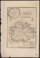
- Creator:
- Bowen, Emanuel, d. 1767
- Published / Created:
- 1747]
- Call Number:
- 8555 1747
- Container / Volume:
- BRBL_00642
- Image Count:
- 1
- Resource Type:
- Maps, Atlases & Globes
- Found in:
- Beinecke Rare Book and Manuscript Library > A new & accurate map of the Island of Jamaica [cartographic material] : divided into its principal parishes / drawn from surveys, and regulated by astronl. observatns. by Eman. Bowen.
- Creator:
- Bowen, Emanuel, d. 1767
- Published / Created:
- 1747]
- Call Number:
- 8555 1752A
- Container / Volume:
- BRBL_00695
- Image Count:
- 1
- Resource Type:
- Maps, Atlases & Globes
- Found in:
- Beinecke Rare Book and Manuscript Library > A new & accurate map of the Island of Jamaica [cartographic material] : divided into its principal parishes / drawn from surveys, and regulated by astronl. observatns. by Eman. Bowen.
- Creator:
- Bowen, Emanuel, d. 1767
- Published / Created:
- 1747]
- Call Number:
- 8612 1747
- Container / Volume:
- BRBL_00696
- Image Count:
- 1
- Resource Type:
- Maps, Atlases & Globes
- Found in:
- Beinecke Rare Book and Manuscript Library > A new and accurate map of the island of Antigua or Antego [cartographic material] : taken from surveys, and adjusted by astronl. observations : containing all the towns, parish churches, forts, castles, windmills, roads &c. / by Eman. Bowen.
- Published / Created:
- 1762]
- Call Number:
- 855 1762A
- Container / Volume:
- BRBL_00695
- Image Count:
- 1
- Resource Type:
- Maps, Atlases & Globes
- Found in:
- Beinecke Rare Book and Manuscript Library > A new chart of the seas surrounding the island of Cuba with the soundings, currents, ships, courses &c. and a map of the island itself lately made by an officer in the Navy [cartographic material].
- Creator:
- Morris, Charles, fl. 1749, cartographer
- Published / Created:
- 1751
- Call Number:
- 732 H13 1751
- Container / Volume:
- BRBL_00708
- Image Count:
- 1
- Resource Type:
- Maps, Atlases & Globes
- Found in:
- Beinecke Rare Book and Manuscript Library > A plan of the harbour of Halifax / by Charles Morris, chf. surveyr.
- Creator:
- Seller, John, fl. 1658-1698
- Published / Created:
- 1677]
- Call Number:
- 40 V55 1680A
- Image Count:
- 1
- Resource Type:
- Maps, Atlases & Globes
- Found in:
- Beinecke Rare Book and Manuscript Library > A sea chart of the Gulph of Venice : describing all the sea coasts and islands contained therein.
- Published / Created:
- 1794
- Call Number:
- 38cea 1757
- Container / Volume:
- BRBL_00169
- Image Count:
- 1
- Resource Type:
- Maps, Atlases & Globes
- Found in:
- Beinecke Rare Book and Manuscript Library > An accurate chart of the Bay of Biscay ... taken in 1756 & 1757 ... By Mr. Magin Engineer to the Marine.
- Creator:
- Jefferys, Thomas, d. 1771
- Published / Created:
- 25 May, 1775.
- Call Number:
- 7345cea 1775
- Container / Volume:
- BRBL_00689
- Image Count:
- 1
- Resource Type:
- Maps, Atlases & Globes
- Found in:
- Beinecke Rare Book and Manuscript Library > An exact chart of the river St. Laurence : from Fort Frontenac to the island of Anticosti shewing the soundings, rocks, shoals & c with views of the lands and all necessary instructions for navigating that river to Quebec / by ... Thos. Jefferys.
- Creator:
- Jefferys, Thomas, d. 1771
- Published / Created:
- 25 May, 1775.
- Call Number:
- 7345cea 1775
- Container / Volume:
- BRBL_00381
- Image Count:
- 1
- Resource Type:
- Maps, Atlases & Globes
- Found in:
- Beinecke Rare Book and Manuscript Library > An exact chart of the river St. Laurence : from Fort Frontenac to the island of Anticosti shewing the soundings, rocks, shoals & c with views of the lands and all necessary instructions for navigating that river to Quebec / by ... Thos. Jefferys.
- Creator:
- United States. Hydrographic Office
- Published / Created:
- 1904
- Call Number:
- 57 1904
- Container / Volume:
- BRBL_00302
- Image Count:
- 1
- Resource Type:
- Maps, Atlases & Globes
- Found in:
- Beinecke Rare Book and Manuscript Library > Asia, Japan and Korea : with the surrounding seas and the adjacent coastal region of China / published at Washington, D.C. Feb. 1904, at the Hydrographic Office. H.M. Hodges, Lieutenant Commander, U.S.N. Hydrographer.
- Creator:
- United States. Hydrographic Office
- Published / Created:
- 1904
- Call Number:
- 556cea 1904
- Container / Volume:
- BRBL_00293
- Image Count:
- 1
- Resource Type:
- Maps, Atlases & Globes
- Found in:
- Beinecke Rare Book and Manuscript Library > Asia, Japan and Korea : with the surrounding seas and the adjacent coastal region of China / published at Washington, D.C. Feb. 1904, at the Hydrographic Office. H.M. Hodges, Lieutenant Commander, U.S.N. Hydrographer.
- Creator:
- Great Britain. Hydrographic Dept
Stokes, J. Lort (John Lort), 1811-1885
- Published / Created:
- Aug. 16th. 1852 [i.e. 1865]
- Call Number:
- 26cea 1851A
- Container / Volume:
- BRBL_00023
- Image Count:
- 1
- Resource Type:
- Maps, Atlases & Globes
- Found in:
- Beinecke Rare Book and Manuscript Library > Australia east coast. Sheet I, Cape Howe to Barriga Point / from a running survey by Captn. J. Lort Stokes ... 1851.
- Creator:
- Great Britain. Hydrographic Dept
Stokes, J. Lort (John Lort), 1811-1885
- Published / Created:
- Aug. 16th. 1852 [i.e. 1865]
- Call Number:
- 26cea 1851B
- Container / Volume:
- BRBL_00023
- Image Count:
- 1
- Resource Type:
- Maps, Atlases & Globes
- Found in:
- Beinecke Rare Book and Manuscript Library > Australia east coast. Sheet II, Barriga Point to Jervis Bay / from a running survey by Captn. J. Lort Stokes ... 1851 ; engraved by J. & C. Walker.
- Creator:
- Great Britain. Hydrographic Dept
Potter, J. D
- Published / Created:
- Aug. 16th. 1852 [i.e. 1862]
- Call Number:
- 26cea 1851D
- Container / Volume:
- BRBL_00023
- Image Count:
- 1
- Resource Type:
- Maps, Atlases & Globes
- Found in:
- Beinecke Rare Book and Manuscript Library > Australia east coast. Sheet IV, Broken Bay to Sugarloaf Point / from a running survey by Captn. J. Lort Stokes ... 1851 ; engraved by J. & C. Walker.
- Creator:
- Evans, F. J. (Frederick J.)
Great Britain. Hydrographic Dept
J. & C. Walker (Firm)
Potter, J. D. (John D.)
Washington Capt
- Published / Created:
- Decr. 12th 1860.
- Call Number:
- 26cea 1860
- Container / Volume:
- BRBL_00023
- Image Count:
- 1
- Resource Type:
- Maps, Atlases & Globes
- Found in:
- Beinecke Rare Book and Manuscript Library > Australia, Coral Sea and Great Barrier Reefs shewing the inner and outer routes to Torres Strait. Sheet 2 : from the surveys of Captains Blackwood, Owen Stanley, and Yule, R.N., 1842-50 : the outer detached reef's from Captains Flinders and Denham, Royal
- Creator:
- Great Britain. Hydrographic Department, author
- Call Number:
- 254cea 1886
- Container / Volume:
- BRBL_00021
- Image Count:
- 1
- Resource Type:
- Maps, Atlases & Globes
- Found in:
- Beinecke Rare Book and Manuscript Library > Australia, Coral Sea and Great Barrier Reefs, showing the Inner and Outer routes to Torres Strait. Sheet 2 / engraved by Edwd. Weller.
- Creator:
- Great Britain. Admiralty
- Published / Created:
- 1894 [i.e. 1903?]
- Call Number:
- 261cea T636 1894
- Container / Volume:
- BRBL_00022
- Image Count:
- 1
- Resource Type:
- Maps, Atlases & Globes
- Found in:
- Beinecke Rare Book and Manuscript Library > Australia, north coast, Torres Strait. Thursday Island Harbour / surveyed by Mr. E.A. Cullen.
- Published / Created:
- 1883
- Call Number:
- 764cea B65 1883A
- Container / Volume:
- BRBL_00461
- Image Count:
- 1
- Resource Type:
- Maps, Atlases & Globes
- Found in:
- Beinecke Rare Book and Manuscript Library > Boston Bay and Harbor, Massachusetts. / United States Coast Survey.
- Published / Created:
- 1883
- Call Number:
- 764cea B98 1883
- Container / Volume:
- BRBL_00461
- Image Count:
- 1
- Resource Type:
- Maps, Atlases & Globes
- Found in:
- Beinecke Rare Book and Manuscript Library > Buzzard's Bay [Massachusetts] / United States Coast Survey.
- Creator:
- Robijn, Jacobus, d. ca. 1710
- Published / Created:
- 1687
- Call Number:
- 7855 1687
- Container / Volume:
- BRBL_00691
- Image Count:
- 1
- Resource Type:
- Maps, Atlases & Globes
- Found in:
- Beinecke Rare Book and Manuscript Library > Caerte vande cust Carolina : tusschen B. de S Matheo en C. Henry / op niew verbeetert door Iacobus Robyn.
- Creator:
- Peirce, Benjamin, 1809-1880
United States Coast Survey
- Published / Created:
- 1869
- Call Number:
- 846cea Or4 1869
- Container / Volume:
- BRBL_00623
- Image Count:
- 1
- Resource Type:
- Maps, Atlases & Globes
- Found in:
- Beinecke Rare Book and Manuscript Library > Cape Orford and reef, Oregon / U.S. Coast Survey, Benjamin Peirce, superintendant ; triangulation by A.W. Chase, sub-assistant in 1869 ; topography by A.M. Harrison, assist. and A.W. Chase, sub-assistant in 1851 & '69 ; hydrography by Commander J. Alden U
- Creator:
- Pinheiro, Simão Antônio da Rosa
- Published / Created:
- anno de 1786.
- Call Number:
- Art Storage 1006
- Container / Volume:
- BRBL_00700
- Image Count:
- 1
- Resource Type:
- Maps, Atlases & Globes
- Found in:
- Beinecke Rare Book and Manuscript Library > Carta reduzida, e em muijte parte reformada, pelas observacoens mais justificadas dos melhores authores, astronomos modernos, [que] pareceraõ mais coherentes, pelas exaetissimas averiguacoens de pilotos eruditos, e do roterro portugues : em que se compre
- Creator:
- Buache, Philippe, 1700-1773
- Published / Created:
- [1740]
- Call Number:
- 85 1740B
- Container / Volume:
- BRBL_00693
- Image Count:
- 1
- Resource Type:
- Maps, Atlases & Globes
- Found in:
- Beinecke Rare Book and Manuscript Library > Carte d'une partie de l'Amérique [cartographic material] : pour la navigation des isles et du Golfe du Mexique avec l'interieur des terres depuis la Bermude jusqu'a Cayenne, partie meridionale, reduite de la carte angloise en 20 feuilles / par Mr. Popple
- Creator:
- Denis, Louis, 1725-1794
- Published / Created:
- [1781]
- Call Number:
- 399 1781
- Container / Volume:
- BRBL_00195
- Image Count:
- 1
- Resource Type:
- Maps, Atlases & Globes
- Found in:
- Beinecke Rare Book and Manuscript Library > Carte de la baye de Gibraltar et de ses environs / nouvellement corrigé et augmenté d'après les originaux anglois par L. Denis, géographe et auteur du conducteur françois en 1781 ; A. Coquart, sculpsit.
- Published / Created:
- [between 1693 and 1710?]
- Call Number:
- 783 1711
- Container / Volume:
- BRBL_00691
- Image Count:
- 1
- Resource Type:
- Maps, Atlases & Globes
- Found in:
- Beinecke Rare Book and Manuscript Library > Carte particuliere de Virginie, Maryland, Pennsilvanie, la Nouvelle Iarsey orient et occidentale.
- Creator:
- France. Dépôt général de la marine
- Published / Created:
- 1779
- Call Number:
- 732cea 1779
- Container / Volume:
- BRBL_00377
- Image Count:
- 1
- Resource Type:
- Maps, Atlases & Globes
- Found in:
- Beinecke Rare Book and Manuscript Library > Carte reduite de l'Acadie ou Nouvelle Ecosse : comprenant une partie de l'Isle Royale, de l'Isle St. Jean et du Canada / dressée au Dépôt Général des Cartes, Plans et Journaux de la Marine, pour le service des vaisseaux du Roi, par ordre de M. de Sar
- Creator:
- Bellin, Jacques Nicolas, 1703-1772
- Published / Created:
- 1764
- Call Number:
- 85 1764
- Container / Volume:
- BRBL_00693
- Image Count:
- 1
- Resource Type:
- Maps, Atlases & Globes
- Found in:
- Beinecke Rare Book and Manuscript Library > Carte reduite des costes de la Louisiane et de la Floride / [cartographic material] / dressée au Dépost des cartes, plans et journaux de la Marine pour le service des vaisseaux du roy par ordre de M. Le Duc de Choisel, colonel général des Suisses et G
- Published / Created:
- 1851].
- Call Number:
- 11cfk 1850B-3
- Container / Volume:
- BRBL_00770
- Image Count:
- 1
- Resource Type:
- Maps, Atlases & Globes
- Found in:
- Beinecke Rare Book and Manuscript Library > Chart Of The North East Trade Winds [cartographic material] / National Observatory.
- Creator:
- Sherman & Smith
- Published / Created:
- 1874?]
- Call Number:
- 19cea 1874
- Container / Volume:
- BRBL_00013
- Image Count:
- 1
- Resource Type:
- Maps, Atlases & Globes
- Found in:
- Beinecke Rare Book and Manuscript Library > Chart of the Antarctic continent : shewing the icy barrier attached to it, discovered by the U.S. Ex. Ex., Charles Wilkes, Esq., Commander, 1840.
- Creator:
- Faden, William, 1749-1836
Palmer, W. (William), 1739-1812
Roberts, Henry, Lieut
- Published / Created:
- 1784
- Call Number:
- 23 1784
- Container / Volume:
- BRBL_00019
- Image Count:
- 1
- Resource Type:
- Maps, Atlases & Globes
- Found in:
- Beinecke Rare Book and Manuscript Library > Chart of the N.W. coast of America and the N.E. coast of Asia, explored in the years 1778 and 1779 / prepared by Lieut. Heny. Roberts, under the immediate inspection of Capt. Cook ; engraved by W. Palmer.
- Published / Created:
- 1902
- Call Number:
- 67 1902
- Container / Volume:
- BRBL_00348
- Image Count:
- 1
- Resource Type:
- Maps, Atlases & Globes
- Found in:
- Beinecke Rare Book and Manuscript Library > Costa Occidental de Africa. Hoja I. Comprende desde cabo de San Vicente hasta Cabo Yuby. Con inclusion de las islas Canarias y de Madera.
- Creator:
- Carvalho, Manoel Lourenço Vasco de
- Published / Created:
- 1890
- Call Number:
- BrSides Folio 2019 5
- Image Count:
- 1
- Resource Type:
- Maps, Atlases & Globes
- Found in:
- Beinecke Rare Book and Manuscript Library > Costa oriental d'Africa, provincia de Moçambique plano hydrographico da barra e porto do Rio Chinde / levantado de junho a agosto de 1889, sob a direccão do commandante da canhoneira Liberal Manoel Lourenço Vasco de Carvalho pelos officiaes da armada L. C
- Creator:
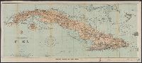
- U.S. Coast and Geodetic Survey
- Published / Created:
- 1898
- Call Number:
- 855hc 1898Q
- Container / Volume:
- BRBL_00765
- Image Count:
- 1
- Resource Type:
- Maps, Atlases & Globes
- Found in:
- Beinecke Rare Book and Manuscript Library > Cuba : part of chart "E" / Treasury Department, U.S. Coast and Geodetic Survey, Henry S. Pritchett, Superintendent.
- Published / Created:
- 1880
- Call Number:
- 754cea B98 1880
- Container / Volume:
- BRBL_00418
- Image Count:
- 2
- Resource Type:
- Maps, Atlases & Globes
- Found in:
- Beinecke Rare Book and Manuscript Library > Eldridge's chart no. 10 : Buzzard's Bay, from the United States Coast and George Eldridge's surveys / published by Thaxter & Son. 125 State St. Boston, 1880.
- Creator:
- Eldridge, George, 1821-1879
- Published / Created:
- 1891
- Call Number:
- 764cea B65 1891E
- Container / Volume:
- BRBL_00461
- Image Count:
- 1
- Resource Type:
- Maps, Atlases & Globes
- Found in:
- Beinecke Rare Book and Manuscript Library > Eldridge's new chart of Boston Harbor : compiled from the latest surveys / engraved by G.W. Boynton.
- Creator:
- United States Coast Survey
- Published / Created:
- 1883
- Call Number:
- 7645cea 1883
- Container / Volume:
- BRBL_00463
- Image Count:
- 1
- Resource Type:
- Maps, Atlases & Globes
- Found in:
- Beinecke Rare Book and Manuscript Library > Entrance to Nantucket Sound / United States Coast Survey.