Voyage autour du monde par la frégate du Roi la Boudeuse, et la flûte l'Etoile, en 1766, 1767, 1768
Image Count:
1
Resource Type:
Maps, Atlases & Globes
Description:
In French., In upper right margin: Pl. 1., Plate 1 from: Voyage autour du monde : par la frégate du Roi la Boudeuse, et la flûte l'Etoile, en 1766, 1767, 1768, & 1769 / [by Louis Antoine de Bougainville]., Prime meridian: Paris., Watermark., and World map showing route of the Boudeuse and the Etoile. Australia named as Nouvelle Hollande with incomplete coastline and Tasmania named as Terre de Dieman with a portion of incomplete coastline. West coast of Australia mapped. Australia appears conjoined to New Guinea.
Publisher:
[De l'imprimerie de Le Breton ...],
Subject (Name):
Boudeuse (Frigate), Bougainville, Louis-Antoine de, comte, 1729-1811. Voyage autour du monde : par la frégate du Roi la Boudeuse, et la flûte l'Etoile, en 1766, 1767, 1768, & 1769., Etoile (Ship), and Saillant & Nyon.
Subject (Topic):
Voyages around the world--Early works to 1800. and World maps.
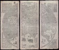
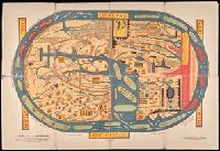
"咸豐庚申降婁海東重刊", "治理曆法極西南懷仁立法", Based on the world map of Joannes Blaeu., Includes illus. and text., Relief shown pictorially., Reprint., Shows the world in two hemispheres., and Wood block prints.
Publisher:
[publisher not identified],
Subject (Name):
Blaeu, Joan, 1596-1673.
Subject (Topic):
Chinese rare maps. and World maps--Early works to 1800.
Orbis terrarvm typvs de integro multis in locis emendatus
Description:
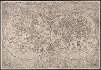
Copy 1: Imperfect: chipped along folds, with some loss of text. Backed with linen. and Double hemispherical map of the world, with 2 smaller celestial hemispheres. New Guinea shown as part of southern continent called Magallanica. The two hemispheres are surr
Orbis terrarvm typvs de integro multis in locis emendatus
Description:
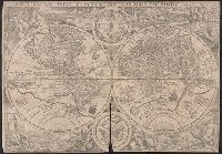
Copy 2: Imperfect: chipped along folds, with some loss of text. Backed with paper. and Double hemispherical map of the world, with 2 smaller celestial hemispheres. New Guinea shown as part of southern continent called Magallanica. The two hemispheres are surr
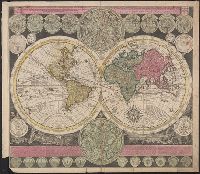
Vlakke aard-kloot met het beide hemelsch half-rond, of de onder scheidene verbeelding van de land-water-waereld
Description:
"De Warmoes Straat sub signo R. Visschers Athlas"., Cross collection no. 29., Double hemispherical world map showing routes of explorers including Magellan, Dampier, Tasman and Chaumont., Includes twenty-six smaller astronomical diagrams and hemispheres of the world, two larger celestial hemispheres and textual commentary., and Relief shown pictorially.
Publisher:
Ex officina Petri Schenkii ...,
Subject (Geographic):
Australia--Maps--Early works to 1800
Subject (Name):
Schenk, Peter, 1660-1718 or 1719. Atlas contractus