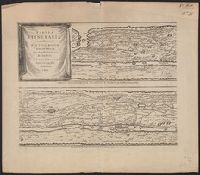
Peutinger table. and Tabula itineraria ex illustri Peutingerorum
Description:
Tabvlae Pevtingerianae segmentvm primvm, ab ostiis Rheni bonnam vsque -- Segmentvm secvndvm à bonna vsque ad Marcomannos -- Tabvlae Pevtingerianae segmentvm III a Marcomannis ad Sarmatas vsque -- Segmentvm IV a Sarmatis vsque ad Hamaxobios -- Tabvlae Pevtingerianae segmentvm V a Sarmatis Hamaxobis vsque ad Roxulanas -- Segmentvm VI a Sarmatis Roxulanis vsque ad Parnacos -- Tabvlae Pevtingerianae segmentvm VII a Parnacis vsque ad Paralocas Schythas -- Segmentvm VIII a Paralocis Schythis vsque ad finem Asiae.
Publisher:
prostant apud Joannem Janssonium,
Subject (Name):
Horn, Georg, 1620-1670, Jansson, Jan, 1588-1664. Accuratissima Orbis antiqui delineatio... [1652?], Jansson, Jan, 1588-1664. Novus atlas, Peutinger, Konrad, 1465-1546 or 7, and Welser, Marcus, 1558-1614
Subject (Topic):
Roads, Roman--Maps--Early works to 1800 and World maps--Early works to 1800
Horn, Georg, 1620-1670 Jansson, Jan, 1588-1664. Accuratissima Orbis antiqui delineatio... [1652?] Jansson, Jan, 1588-1664. Novus Atlas Peutinger, Konrad, 1465-1546 or 7 Welser, Marcus, 1558-1614
Published / Created:
1652?]
Call Number:
314 1654
Container / Volume:
BRBL_00038
Image Count:
4
Resource Type:
Maps, Atlases & Globes
Alternative Title:
Peutinger table. and Tabula itineraria ex illustri Peutingerorum
Description:
From: Accuratissima Orbis antiqui delineatio...by J. Jansson [1652?], Jansson's Peutinger table was reprinted in various editions of Accuratissima Orbis antiqui delineatio and in later editions edited by Georg Horn. Map also appeared in, and Lanman collection.
Publisher:
prostant apud Joannem Janssonium,
Subject (Geographic):
Roman Empire Maps--Early works to 1800
Subject (Topic):
Roads, Roman--Maps--Early works to 1800 and World maps--Early works to 1800
Imperfect: chipped., Insets: Canton River -- Van Diemen's Land -- Mouths of the River Hoogly -- Island and town of Singapore -- Colony of Good Hope., and Relief shown by hachures.
Subject (Name):
Copley, Charles, engraver, Karpinski, Louis Charles,--1878-1956--Ownership., Karpinski-von Wieser Map Collection., and Wieser, Franz,--Ritter von,--1848-1923--Ownership.
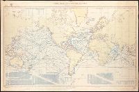
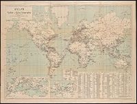
"No. 1262.", "Small corrections from notices to mariners ('15-2, 18, 30, from other sources I '16.", Includes charts: "Speeds per hour with daily and weekly distances in nautical miles" and "Reduction knots on nautical miles to statute miles." Also includes 4 distance charts., and Relief shown by hachures and spot heights.
"No. 1262.", "Small corrections from notices to mariners ('15-2, 18, 30, ('18-4, from other sources I '16, IV '18.", Includes charts: "Speeds per hour with daily and weekly distances in nautical miles" and "Reduction knots on nautical miles to statute miles." Also includes 4 distance charts., and Relief shown by hachures and spot heights.
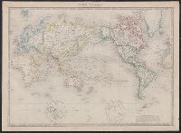
Decorated with sea monsters, mermaids, exotic animals, and cannibals, this wood cut map provides a marked contrast to the simplistic diagrams considered the earliest printed world maps. While the latter presented a world view based in Judeo-Christian theo
Alternative Title:
Typus cosmographicus universalis and Typvs cosmographicvs vniversalis
Description:
Appears in Johann Huttich's Novus orbis regionum. Basel. 1532. and Relief shown pictorially.
Publisher:
[publisher not identified],
Subject (Name):
Holbein, Hans, 1497-1543 and Huttich, Johann, 1480?-1544. Novus orbis regionum.
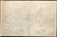
DLC, Includes notes., and The whale chart was released as series F a part of Maury's "Wind and current charts", series A-F. For complete discussion, see "The wind and current chart series produced by Matthew Fontaine Maury," by Marc I. Pinsel, in Navigation : J
Publisher:
National Observatory,
Subject (Name):
Maury, Matthew Fontaine, 1806-1873. Wind and current charts, United States Naval Observatory, United States. Bureau of Ordnance and Hydrography, W. Endicott & Co, and Warrington, L. (Lewis), 1782-1851
Subject (Topic):
Right whales--Maps, Sperm whale--Maps, Whales--Maps, and Whaling--Maps