Skip to search
Skip to main content
Skip to first result
Search
You Searched For
Extent of Digitization
Completely digitized
Genre
World maps
Search Results
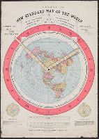
Published / Created:
1892.
Call Number:
11 1892
Image Count:
2
Resource Type:
cartographic image
Abstract:
Map of the globe stretched and flattened into a circular plane (azimuthal projection), with two movable arms to calculate time in places around the world
Alternative Title:
New standard map of the world
Description:
Map of the globe stretched and flattened into a circular plane.
Publisher:
Buffalo Electrotype and Engraving Co.
Subject (Topic):
Map projections and World maps
Found in:
Beinecke Rare Book and Manuscript Library > Gleason's new standard map of the world : on the projection of J.S. Christopher, Modern College, Blackheath, England ; scientifically and practically correct ; as "it is."
Creator:
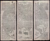
Published / Created:
[Xianfeng geng shen [1860]] and [咸豐庚申[1860]]
Call Number:
11 1860
Image Count:
8
Resource Type:
Maps, Atlases & Globes
Alternative Title:
坤輿全圖 [cartographic material] : [二卷] / [Verbiest, Ferdinand].
Description:
"咸豐庚申降婁海東重刊"
Publisher:
[publisher not identified],
Subject (Name):
Blaeu, Joan, 1596-1673.
Subject (Topic):
Chinese rare maps. and World maps--Early works to 1800.
Found in:
Beinecke Rare Book and Manuscript Library > Kun yu quan tu [cartographic material] : [er juan] / [Verbiest, Ferdinand].
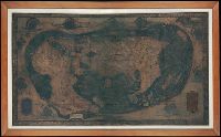
Creator:
Published / Created:
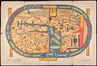
ca. 1489
Call Number:
Art Storage 1980 157
Image Count:
3
Description:
"Opus [fecit?] Henricus Martellus Germanus."
Subject (Geographic):
World maps--Early works to 1800
Found in:
Beinecke Rare Book and Manuscript Library > Map of the world of Christopher Columbus.
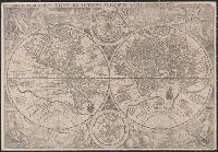
Creator:
Published / Created:
[1594]
Call Number:
11 1594
Container / Volume:
BRBL_00002
Image Count:
1
Resource Type:
Maps, Atlases & Globes
Alternative Title:
Orbis terrarvm typvs de integro multis in locis emendatus
Description:
Copy 1: Imperfect: chipped along folds, with some loss of text. Backed with linen.
Publisher:
[Petrus Plancius],
Subject (Name):
Doetecam, Jan van, engraver
Subject (Topic):
World maps--Early works to 1800
Found in:
Beinecke Rare Book and Manuscript Library > Orbis terrarum typus de integro multis in locis emendatus [cartographic material] / auctore Petro Plancio, 1594 ; Ioannes à Duetecum iunior fecit.
Creator:
Published / Created:
[1594]
Call Number:
11 1594
Container / Volume:
BRBL_00002
Image Count:
1
Resource Type:
Maps, Atlases & Globes
Alternative Title:
Orbis terrarvm typvs de integro multis in locis emendatus
Description:
Copy 2: Imperfect: chipped along folds, with some loss of text. Backed with paper.
Publisher:
[Petrus Plancius],
Subject (Name):
Doetecam, Jan van, engraver
Subject (Topic):
World maps--Early works to 1800
Found in:
Beinecke Rare Book and Manuscript Library > Orbis terrarum typus de integro multis in locis emendatus [cartographic material] / auctore Petro Plancio, 1594 ; Ioannes à Duetecum iunior fecit.
Creator:
Published / Created:
[1709?]
Call Number:
11 1709
Container / Volume:
BRBL_00680
Image Count:
1
Resource Type:
Maps, Atlases & Globes
Alternative Title:
Vlakke aard-kloot met het beide hemelsch half-rond, of de onder scheidene verbeelding van de land-water-waereld
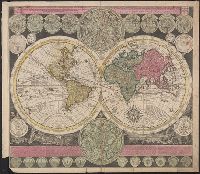
Description:
"De Warmoes Straat sub signo R. Visschers Athlas".
Publisher:
Ex officina Petri Schenkii ...,
Subject (Geographic):
Australia--Maps--Early works to 1800
Subject (Name):
Schenk, Peter, 1660-1718 or 1719. Atlas contractus
Subject (Topic):
World maps--Early works to 1800
Found in:
Beinecke Rare Book and Manuscript Library > Planisphaerium terrestre cum utroque coelesti hemisphaerio, sive diversa orbis terraquei = Vlakke aard-kloot met het beide hemelsch half-rond, of de onder scheidene verbeelding van de land-water-waereld / opera et studio A.F. Zürneri.
Creator:
Published / Created:
[1905?]
Call Number:
BrSides Double Folio 2018 91
Image Count:
1
Resource Type:
Maps, Atlases & Globes
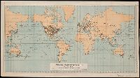
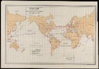
Description:
Manuscript note in right margin: Transportation routes.
Publisher:
Department of Commerce and Labor, Bureau of Statistics,
Subject (Name):
Norris Peters Co
Subject (Topic):
Transportation--Maps and World maps
Found in:
Beinecke Rare Book and Manuscript Library > Principal transportation routes of the world.
Published / Created:
[1895]
Call Number:
BrSides Double Folio 2019 1
Image Count:
1
Resource Type:
Maps, Atlases & Globes
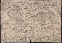
Description:
From Konrad Miller's Mappaemundi (volume 1; 1895).
Publisher:
Verlag von Otto Maier (Dorn'sche Buchhandlung)
Subject (Name):
Miller, Konrad, 1844-1933. Mappaemundi.
Found in:
Beinecke Rare Book and Manuscript Library > S. Beati Liebanensis mappam mundi ad exemplar ecclesiae Snacto Severi, quod nunc Parisiis asservatur, primum integram edidit Conradus Miller.
Published / Created:
[1898]
Call Number:
BrSides Folio 2019 2
Image Count:
1
Resource Type:
Maps, Atlases & Globes
Alternative Title:
Sphaera julii honorii
Description:
"Miller Mappaemundi VI, Taf. 4." in upper left corner.
Publisher:
[J. Roth],
Subject (Name):
Miller, Konrad, 1844-1933. Mappaemundi.
Found in:
Beinecke Rare Book and Manuscript Library > Sphaera jvlii honorii.
Creator:
Published / Created:
[1899]
Call Number:
BrSides Folio 2019 64
Image Count:
1
Resource Type:
Maps, Atlases & Globes
Description:
Includes explanation key.
Publisher:
Norris Peters Co.,
Subject (Name):
Norris Peters Co.
Subject (Topic):
Cables, Submarine--Maps. and World maps
Found in:
Beinecke Rare Book and Manuscript Library > Submarine and land telegraph systems of the world [cartographic material].
Branch:v1.68.6 ,Deployed:2025-07-02T08:09:49-04:00