Search
You Searched For
Search Results
- Creator:
- United States. Office of Strategic Services. Research and Analysis Branch
- Published / Created:
- 1945
- Call Number:
- 36eb 1939A
- Container / Volume:
- BRBL_00127
- Image Count:
- 1
- Resource Type:
- Maps, Atlases & Globes
- Description:
- "No. 6356, R.A., OSS, 10 April 1945."
- Publisher:
- R & A, OSS,
- Subject (Geographic):
- Europe, Central--Maps and Germany--Maps
- Subject (Topic):
- Working class--Europe, Central--Maps and Working class--Germany--Maps
- Found in:
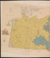
- Beinecke Rare Book and Manuscript Library > "Greater" Germany, population dependent upon commercial and service occupations (by Kreise 1939).
- Creator:
- United States. Office of Strategic Services. Research and Analysis Branch
- Published / Created:
- 1945
- Call Number:
- 36eb 1939A
- Container / Volume:
- BRBL_00127
- Image Count:
- 1
- Resource Type:
- Maps, Atlases & Globes
- Description:
- "No. 6356, R.A., OSS, 10 April 1945."
- Publisher:
- R & A, OSS,
- Subject (Geographic):
- Europe, Central--Maps and Germany--Maps
- Subject (Topic):
- Working class--Europe, Central--Maps and Working class--Germany--Maps
- Found in:
- Beinecke Rare Book and Manuscript Library > "Greater" Germany, population dependent upon commercial and service occupations (by Kreise 1939).
- Creator:
- United States. Office of Strategic Services. Research and Analysis Branch
- Published / Created:
- 1945
- Call Number:
- 36eb 1945A
- Container / Volume:
- BRBL_00127
- Image Count:
- 1
- Resource Type:
- Maps, Atlases & Globes
- Description:
- "No. 7113--R & A, IRIS 31 October 1945."
- Publisher:
- The Branch,
- Subject (Geographic):
- Germany--Maps and Germany--Population--Maps
- Found in:
- Beinecke Rare Book and Manuscript Library > "Greater" Germany. : population change by Kreise, circa 1933-1939.
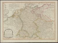
- Published / Created:
- 1805
- Call Number:
- 36 1805A
- Container / Volume:
- BRBL_00119
- Image Count:
- 1
- Resource Type:
- Maps, Atlases & Globes
- Publisher:
- Laurie & Whittle,
- Subject (Geographic):
- Germany--Maps
- Found in:
- Beinecke Rare Book and Manuscript Library > A new map of Germany divided into its circles ...
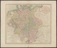
- Creator:
- Cary, John, ca. 1754-1835
- Published / Created:
- April 28, 1811.
- Call Number:
- 36 1811
- Container / Volume:
- BRBL_00119
- Image Count:
- 1
- Resource Type:
- Maps, Atlases & Globes
- Description:
- Pg. no. on verso: 21.
- Publisher:
- Printed for J. Cary, engraver & map-seller, No. 181 Strand,
- Subject (Geographic):
- Germany--Maps
- Found in:
- Beinecke Rare Book and Manuscript Library > A new map of Germany, divided into its circles : viz. the upper and lower Rhine, Swabia, Austria, Bavaria, upper and lower Saxony, Franconia and Westphalia, with the Kingdom of Bohemia &c. From the latest authorities / by John Cary, engraver, 1811.
- Published / Created:
- 1811
- Call Number:
- 36 R34 1811
- Container / Volume:
- BRBL_00126
- Image Count:
- 1
- Resource Type:
- Maps, Atlases & Globes
- Publisher:
- J. Cary,
- Subject (Geographic):
- Germany--Maps
- Found in:
- Beinecke Rare Book and Manuscript Library > A new map of the Circles of the Upper and Lower Rhine ... By John Cary, Engraver.
- Creator:
- Allied Forces
Great Britain. War Office. General Staff. Geographical Section
- Published / Created:
- 1943-
- Call Number:
- 11hd 1942D-44
- Image Count:
- 14
- Resource Type:
- Maps, Atlases & Globes
- Alternative Title:
- [Series] M641, G.S.G.S ; no. 4416, and GSGS (Series) ; 4416.
- Description:
- Marginal maps: Index to adjoining sheets and incidence of grid letters [and] G.S.G.S. 4346, Germany 1:250,000.--Compilation diagram.
- Publisher:
- War Office,
- Subject (Geographic):
- Europe, Central--Maps and Germany--Maps
- Found in:
- Beinecke Rare Book and Manuscript Library > Central Europe 1:100,000.
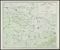
- Creator:
- United States. Office of Strategic Services. Research and Analysis Branch
- Published / Created:
- 1944
- Call Number:
- 36cb 1944
- Container / Volume:
- BRBL_00127
- Image Count:
- 1
- Resource Type:
- Maps, Atlases & Globes
- Description:
- "No. 3293."
- Publisher:
- OSS,
- Subject (Geographic):
- Germany--Maps
- Found in:
- Beinecke Rare Book and Manuscript Library > Central Germany terrain types / compiled and drawn in the Branch of Research and Analysis, OSS.
- Creator:
- George Philip & Son
London Geographical Institute
- Published / Created:
- 1940
- Call Number:
- 36 1940D
- Container / Volume:
- BRBL_00121
- Image Count:
- 1
- Resource Type:
- Maps, Atlases & Globes
- Alternative Title:
- Western Germany, with Holland, Belgium and Switzerland.
- Description:
- "Sizer"--Autograph in upper lef
- Publisher:
- George Philip and Son,
- Subject (Geographic):
- Europe, Eastern--Maps, Germany--Maps, and Hungary--Maps
- Subject (Name):
- Sizer, Theodore,--1892-1967--Autograph
- Found in:
- Beinecke Rare Book and Manuscript Library > Eastern Germany, with Hungary.
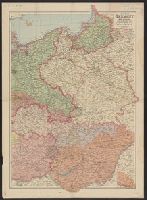
- Creator:
- Great Britain. War Office. General Staff. Geographical Section
- Published / Created:
- 1918
- Call Number:
- 36ed 1918
- Container / Volume:
- BRBL_00127
- Image Count:
- 2
- Resource Type:
- Maps, Atlases & Globes
- Alternative Title:
- GSGS (Series) ; 3703a. and GSGS ; 3703a
- Description:
- Germany -- Poland -- Northern Italy -- South east Europe.
- Publisher:
- War Office,
- Subject (Geographic):
- Balkan Peninsula--Maps, Germany--Maps, Italy, Northern--Maps, and Poland--Maps
- Found in:
- Beinecke Rare Book and Manuscript Library > Ethnographical map [cartographic material].