Luisiana, aņo de 1798, sur d'oueste de la ciudad. and Plano de la ciudad de Nueva Orleans.
Description:
"Luisiana, año de 1798, sur d'oueste de la ciudad," in French, Spanish and English, dated Marzo, 16 de 1798, and signed: Carlos Trudeau., "Plano de la ciudad de Nueva Orleans" in French and Spanish, dated 6 de Agosto 1799, and signed at end: Carlos Trudeau., At foot of map, "Luisiana, año de 1798 ... ": Recorded in the Book No. 3, page 216, New Orleans, juin 3th 1808. Van Pradelles ..., Maps are hand colored. Old fold marks visible., and Two folding plans of New Orleans by Charles Trudeau; to accompany Thierry's Examen des droits des Etats Unis ... , Nouvelle-Orleans, De l'imprimerie de Thierry & Co., 1808.
Publisher:
s.n.,
Subject (Geographic):
New Orleans (La.)--Maps
Subject (Name):
Thierry, J. B. S. (Jean Baptiste Simon), d. 1815. Examen des droits des Etats-Unis et des pretentions de Mr. Edouard Livingston sur la batture en face du faubourg Ste. Marie. and Thierry, J. B. S.--(Jean Baptiste Simon),--d. 1815.--Examen des droits des Etats-Unis et des pretentions de Mr. Edouard Livingston sur la batture en face du faubourg Ste. Marie.
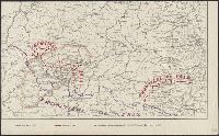
Map page from Atlas VIDAL-LABLACHE. Shows "Allied forces in black. Bolshevist forces in blue" with corresponding ms. notes on map. Ms. notes detail nationalities and commanders of individual forces and their placement. Map text in French, ms. notes in Eng
"Nota" with details of changes in positions during the siege., Inset: "Explication des lettres du plan.", Map shows fortifications around the city, the positions of the French, American and British batteries, roads to surrounding towns, and the Savannah and Augustine rivers., Pen and ink ms. signed "O'Connor"., and Title supplied by cataloger.
Subject (Geographic):
Savannah (Ga.)--History--Siege, 1779--Maps, Manuscript--Early works to 1800 and Savannah (Ga.)--Maps, Manuscript--Early works to 1800