Skip to search
Skip to main content
Skip to first result
Search
You Searched For
Extent of Digitization
Completely digitized
Access
Public
Repository
Beinecke Rare Book and Manuscript Library
Resource Type
Maps, Atlases & Globes
Language
German
New Search
Search Results
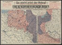
Published / Created:
191-.
Call Number:
11hc 1915R
Container / Volume:
BRBL_00010C
Image Count:
2
Resource Type:
Maps, Atlases & Globes
Description:
Includes 2 maps, text, and ill. and On verso: 4 anciallry maps, text, and ill.
Publisher:
Julius Hans Forkel,
Subject (Geographic):
Germany--Maps
Subject (Topic):
World War, 1914-1918--Maps
Found in:
Beinecke Rare Book and Manuscript Library > [So steht jetzt der Krieg!] : Kriegsoperationskarte über alle Kriegsschauplätze der welt.
Creator:
Published / Created:
[1876]
Call Number:
BrSides Folio 2019 105
Image Count:
10
Resource Type:
Maps, Atlases & Globes
Description:
Dissected and mounted on linen. Labels with sheet titles in manuscript on verso. Includes additional "Ausg. 1877" for southernmost sheet ("Lussina u. Osero")., Fasine & Canale della Morlacca -- Cherso u. Canale dell' Arsa -- Osero u. Lussina -- Pola., and Relief shown by hachures.
Publisher:
[K.K. Militaerisch-Geografischen Institute],
Subject (Geographic):
Hungary--Maps.
Found in:
Beinecke Rare Book and Manuscript Library > [Special-Karte des Königreichs Ungarn].
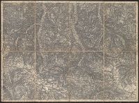
Published / Created:
1877
Call Number:
425 R119 1877
Container / Volume:
BRBL_00246
Image Count:
2
Resource Type:
Maps, Atlases & Globes
Description:
Title supplied by cataloger.
Publisher:
[K.u.k. militär-geographischen Institut],
Subject (Geographic):
Austria--Maps
Found in:
Beinecke Rare Book and Manuscript Library > [Specialkarte des österr. Alpengebietes 1:75.000.] Zone 16 Col. IX, Radstadt.
Published / Created:
1876
Call Number:
425 H676 1876
Container / Volume:
BRBL_00246
Image Count:
2
Resource Type:
Maps, Atlases & Globes
Description:
Title supplied by cataloger.
Publisher:
[K.u.k. militär-geographischen Institut],
Subject (Geographic):
Austria--Maps
Found in:
Beinecke Rare Book and Manuscript Library > [Specialkarte des österr. Alpengebietes 1:75.000.] Zone 17 Col. VIII, Hof-Gastein.
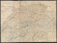
Published / Created:
1820?]
Call Number:
37 1820A
Image Count:
2
Resource Type:
Maps, Atlases & Globes
Description:
5 insets in border.
Publisher:
Heinrich Keller,
Subject (Geographic):
Switzerland--Maps
Found in:
Beinecke Rare Book and Manuscript Library > [Switzerland]
Published / Created:
1864
Call Number:
37 1907B
Container / Volume:
BRBL_00149
Image Count:
1
Resource Type:
Maps, Atlases & Globes
Description:
"Blatt XLII", "Interlachen", "Sarnen Stanz".
Publisher:
Swiss Government],
Subject (Geographic):
Switzerland--Maps
Found in:
Beinecke Rare Book and Manuscript Library > [Switzerland] / G.H. Dufour direxit; H. Müllhaupt sculpsit.
Published / Created:
[1940?]
Call Number:
456 1918
Container / Volume:
BRBL_00259
Image Count:
1
Resource Type:
Maps, Atlases & Globes
Description:
Red lines connecting some towns printed over base map.
Publisher:
Kgl. Ung. Staatl. Kartographischen Institutes,
Subject (Geographic):
Transylvania (Romania)--Maps
Found in:
Beinecke Rare Book and Manuscript Library > [Transylvania] / Entworfen von Robert Csallner.
Published / Created:
[1940?]
Call Number:
456 1918A
Container / Volume:
BRBL_00259
Image Count:
1
Resource Type:
Maps, Atlases & Globes
Description:
Red lines connecting some towns printed over base map. and Relief shown by shading.
Publisher:
Kgl. Ung. Staatl. Kartographischen Institutes,
Subject (Geographic):
Transylvania (Romania)--Maps
Found in:
Beinecke Rare Book and Manuscript Library > [Transylvania] / Entworfen von Robert Csallner.
Published / Created:
[1940?]
Call Number:
456 1940A
Container / Volume:
BRBL_00259
Image Count:
1
Resource Type:
Maps, Atlases & Globes
Description:
In lower left corner: "M.224/935L." and Relief shown by shading.
Publisher:
Kgl. Ung. Staatl. Kartographischen Institutes,
Subject (Geographic):
Transylvania (Romania)--Maps
Found in:
Beinecke Rare Book and Manuscript Library > [Transylvania] / Entworfen von Robert Csallner.
Published / Created:
1823
Call Number:
89 1823
Container / Volume:
BRBL_00657
Image Count:
1
Resource Type:
Maps, Atlases & Globes
Description:
Texts on borders of map.
Publisher:
Geographisches Institut,
Subject (Geographic):
Central America--Maps
Found in:
Beinecke Rare Book and Manuscript Library > geographisch-statistische charte von Guatemala.
Branch:v1.61.8 ,Deployed:2024-06-20T11:14:55-04:00