Skip to search
Skip to main content
Skip to first result
Search
You Searched For
Extent of Digitization
Completely digitized
Language
German
Subject (Geographic)
France--Maps
New Search
Search Results
Creator:
Published / Created:
1940
Call Number:
11hd 1942D-54
Container / Volume:
BRBL_00010ZE
Image Count:
1
Resource Type:
Maps, Atlases & Globes
Alternative Title:
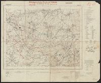
Frankreich and St. Amand
Description:
"Stand 29.3.1940, teilweise 7.4.1940." and Includes legend, list of abbreviations, chart of connecting sheets, and map showing political boundaires.
Publisher:
German General Staff,
Subject (Geographic):
France--Maps
Found in:
Beinecke Rare Book and Manuscript Library > Befestigungskarte Frankreich 1:25000 : St. Amand, Nr. 1-2, XXVI-5/1-2.
Creator:
Published / Created:
1940
Call Number:
11hd 1942D-54
Container / Volume:
BRBL_00010ZE
Image Count:
1
Resource Type:
Maps, Atlases & Globes
Alternative Title:
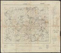
Frankreich and St. Amand
Description:
"Stand 29.3.1940, teilweise 7.4.1940." and Includes legend, list of abbreviations, chart of connecting sheets, and map showing political boundaires.
Publisher:
German General Staff,
Subject (Geographic):
France--Maps
Found in:
Beinecke Rare Book and Manuscript Library > Befestigungskarte Frankreich 1:25000 : St. Amand, Nr. 1-2, XXVI-5/1-2.
Creator:
Published / Created:
[1880]
Call Number:
38CBF 1880
Container / Volume:
BRBL_00168
Image Count:
1
Resource Type:
Maps, Atlases & Globes
Description:
Inset: Corse. and Relief shown by contours, shading, and gradient tints.
Publisher:
Verlag der Dalp'schen Buchhandlung,
Subject (Geographic):
Corsica (France)--Maps and France--Maps
Subject (Name):
Wurster, Randegger & Cie
Found in:
Beinecke Rare Book and Manuscript Library > Carte physique et géographique de la France [cartographic material] / par R. Leuzinger ; étab., top., & lith. de Wurster, Randegger & co.
Published / Created:
1809
Call Number:
38 1809
Container / Volume:
BRBL_00154
Image Count:
1
Resource Type:
Maps, Atlases & Globes
Publisher:
Im Verlag bei Joh. Walch,
Subject (Geographic):
France--Maps
Subject (Name):
Walch, Johannes
Found in:
Beinecke Rare Book and Manuscript Library > Charte von Frankreich, in departements eingetheilt ...
Published / Created:
1941
Call Number:
38hc 1940
Container / Volume:
BRBL_00172
Image Count:
1
Resource Type:
Maps, Atlases & Globes
Description:
"Nr. 288".
Publisher:
Keller & Nehmann,
Subject (Geographic):
France--Maps
Found in:
Beinecke Rare Book and Manuscript Library > Der Sieg im Westen / nach einem Original von G. Amelung.
Creator:
Published / Created:
1872-1876.
Call Number:
38j
Container / Volume:
BRBL_00173
Image Count:
7
Resource Type:
Maps, Atlases & Globes
Alternative Title:
Hand-Atlas für die Geschichte des Mittelalters und der neueren Zeit., Spruner-Menke hist. Handatlas., and Spruner-Menke historischer Handatlas.
Description:
Cover title. and Running title: Spruner-Menke: Hist. Handatlas.
Publisher:
J. Perthes,
Subject (Geographic):
France--Maps
Subject (Name):
Menke, Th. (Theodor), 1819-1892
Subject (Topic):
Historical geography--Maps
Found in:
Beinecke Rare Book and Manuscript Library > Dr. K. v. Spruner's Hand-Atlas für die Geschichte des Mittelalters und der neueren Zeit. Frankreich.
Published / Created:
1918
Call Number:
11hc 1918-Z18
Container / Volume:
BRBL_00010G
Image Count:
1
Resource Type:
Maps, Atlases & Globes
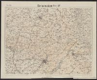
Description:
"Die braunen Schichtlinien umgrenzen Stufen von 10 meter Höhen-Abstand.", "Febr.1918." above upper left margin., "Kartographische Abteilung d. Kgl. Preuβ. Landesaufnahme.", German and French., Includes index of connecting sheets., and Shows area surrounding St. Q
Publisher:
s.n.,
Subject (Geographic):
France--Maps
Found in:
Beinecke Rare Book and Manuscript Library > Einheitsblatt Nr.14F.
Published / Created:
1918
Call Number:
11hc 1918-Z19
Container / Volume:
BRBL_00010G
Image Count:
1
Resource Type:
Maps, Atlases & Globes
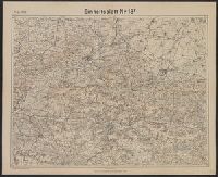
Description:
"Die braunen Schichtlinien umgrenzen Stufen von 10 meter Höhen-Abstand.", "Febr.1918." above upper left margin., "Kartographische Abteilung d. Kgl. Preuβ. Landesaufnahme.", German, Includes index of connecting sheets., and Shows area surrounding Soissons, France.
Publisher:
s.n.,
Subject (Geographic):
France--Maps
Found in:
Beinecke Rare Book and Manuscript Library > Einheitsblatt Nr.18F.
Published / Created:
1918
Call Number:
11hc 1918-Z17
Container / Volume:
BRBL_00010G
Image Count:
1
Resource Type:
Maps, Atlases & Globes
Description:
"April.1918." above upper left margin., "Die braunen Schichtlinien umgrenzen Stufen von 10 meter Höhen-Abstand.", "Kartographische Abteilung d. Kgl. Preuβ. Landesaufnahme.", German and French., Includes index of connecting sheets., and Shows area surrounding Chal
Publisher:
s.n.,
Subject (Geographic):
France--Maps
Found in:
Beinecke Rare Book and Manuscript Library > Einheitsblatt Nr.22F.
Published / Created:
[1915?]
Call Number:
38 1915
Container / Volume:
BRBL_00155
Image Count:
1
Resource Type:
Maps, Atlases & Globes
Alternative Title:
Karte von Frankreich
Description:
Imperfect: upper left corner torn.
Publisher:
Carl Flemming,
Subject (Geographic):
France--Maps
Found in:
Beinecke Rare Book and Manuscript Library > Flemmings Generalkarte. Nr. 28. Karte von Frankreich / Entworfen von F. Handtke.
Branch:v1.61.6 ,Deployed:2024-06-12T09:55:37-04:00