Skip to search
Skip to main content
Skip to first result
Search
You Searched For
Extent of Digitization
Completely digitized
Access
Public
Repository
Beinecke Rare Book and Manuscript Library
Resource Type
Maps, Atlases & Globes
Language
Japanese
New Search
Search Results
Published / Created:
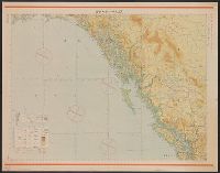
Shōwa 18 [1943] and 昭和 18 [1943]
Call Number:
739CBF 1945 1
Container / Volume:
BRBL_00391
Image Count:
1
Resource Type:
Maps, Atlases & Globes
Alternative Title:
Japan. 陸地測量部., Japan. 陸軍. 参謀本部., and ジュノー--シヤトル / 陸地測量部, 参謀本部.
Description:
"Kōkūzu gunji himitsu (senchi ni arite wa 'bugaihi' to su) ", "Sanbyakuman-bun-no-ichi Han Taih, "三百万分一汎太平洋輿地圖十六號航空圖素圖.", Publication date of 1943 infered by date for the magnetic declination information on map., and Relief shown by contours and gradient tints.
Publisher:
s.n.],
Subject (Geographic):
Alaska--Maps, British Columbia--Maps, and Washington (State)--Maps
Subject (Name):
Japan. Rikuchi Sokuryōbu and Japan. Rikugun. Sanbō Honbu
Subject (Topic):
Aeronautical charts--Alaska, Aeronautical charts--British Columbia, and Aeronautical charts--Washington (State)
Found in:
Beinecke Rare Book and Manuscript Library > Junō--Shiyatoru / Rikuchi Sokuryōbu, Sanbō Honbu.
Published / Created:
[1800?]
Call Number:
57 AT14 1800
Container / Volume:
BRBL_00303
Image Count:
1
Resource Type:
Maps, Atlases & Globes
Description:
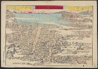
Map shows Oshima Island in the distance.
Publisher:
Yamamoto Koichi, Kansugimura, Kita-Toshimagun,
Subject (Geographic):
Atami-shi (Japan)--Maps--Early works to 1800
Found in:
Beinecke Rare Book and Manuscript Library > Kaisei Atami Shigai Zenzu. [Revised Map of the Entire City of Atami].
Creator:
Published / Created:
Taishō 12 [1923]
Call Number:
56 1923
Container / Volume:
BRBL_00296
Image Count:
1
Resource Type:
Maps, Atlases & Globes
Alternative Title:
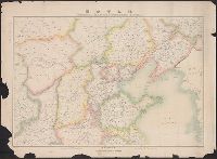
General map of northern China
Description:
"696.", "Tokyo Geographical Society 1921.", and Relief shown by hachures.
Publisher:
Tōkyō Chigaku Kyōkai,
Subject (Geographic):
China--Maps
Subject (Name):
Padley, Benjamina--Early works to 1800
Found in:
Beinecke Rare Book and Manuscript Library > Kita Shina zenzu [cartographic material] = General map of northern China.
Published / Created:
1864
Call Number:
57 K99 1864
Container / Volume:
BRBL_00303
Image Count:
2
Resource Type:
Maps, Atlases & Globes
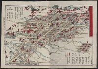
Description:
Orig. publ. 1810.
Subject (Geographic):
Kyoto (Japan)--Maps
Found in:
Beinecke Rare Book and Manuscript Library > Kyō meisho michi go-shiori nozu [Illustrated guide to the streets of Kyoto] At the head of lith: Genji Kaisei [i.e. rev 1864].
Published / Created:
1813
Call Number:
573 1813A
Container / Volume:
BRBL_00310
Image Count:
2
Resource Type:
Maps, Atlases & Globes
Publisher:
Bummendō,
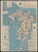
Subject (Geographic):
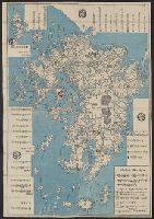
Kyūshū Region (Japan)--Maps
Found in:
Beinecke Rare Book and Manuscript Library > Kyūshū no zu [Map of Kyūshū Island, Japan].
Published / Created:
1813
Call Number:
573 1813
Container / Volume:
BRBL_00310
Image Count:
2
Resource Type:
Maps, Atlases & Globes
Publisher:
Bummendō,
Subject (Geographic):
Kyūshū Region (Japan)--Maps
Found in:
Beinecke Rare Book and Manuscript Library > Kyūshū no zu [Map of Kyūshū Island, Japan].
Published / Created:
[1846?]
Call Number:
57 N134 1846
Container / Volume:
BRBL_00304
Image Count:
1
Resource Type:
Maps, Atlases & Globes
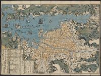
Subject (Geographic):
Japan--Maps
Found in:
Beinecke Rare Book and Manuscript Library > Map of Nagasaki.
Published / Created:
1891
Call Number:
57 N571 1891
Container / Volume:
BRBL_00304
Image Count:
1
Resource Type:
Maps, Atlases & Globes
Description:
Preliminary record.
Subject (Geographic):
Japan--Maps
Found in:
Beinecke Rare Book and Manuscript Library > Map of Niigate.
Published / Created:
[1835?]
Call Number:
58 1835
Container / Volume:
BRBL_00313
Image Count:
1
Resource Type:
Maps, Atlases & Globes
Publisher:
Chen Sung-ting, Wumen, Kiangsu,
Subject (Geographic):
East Asia--Maps
Found in:
Beinecke Rare Book and Manuscript Library > Map of the Far East.
Published / Created:
[1650]
Call Number:
11 1650B
Container / Volume:
BRBL_00003
Image Count:
2
Resource Type:
Maps, Atlases & Globes
Description:
Japanese map showing 6 most important areas: Asia, China, North and South America, Africa and Europe and Micronesia. and Preliminary record.
Subject (Geographic):
World--Maps--Early works to 1800
Found in:
Beinecke Rare Book and Manuscript Library > Map of the World.
Branch:v1.61.8 ,Deployed:2024-06-20T11:15:04-04:00