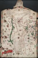
Contains six compass roses., Decoration: city views with banners; five side-view portraits., Imperfect: chipped along left, bottom and top edge, with some loss of map., Includes four bar scales., Pen-and-ink in black, red, blue and green., Portolan chart with seaport names given for all coastlines., and Title devised by cataloger.
Subject (Geographic):
Black Sea--Maps--Early works to 1800., Mediterranean Sea--Maps--Early works to 1800., and North Atlantic Ocean--Maps--Early works to 1800.
Subject (Topic):
Nautical charts--Black Sea--Early works to 1800., Nautical charts--Mediterranean Sea--Early works to 1800., and Nautical charts--North Atlantic Ocean--Early works to 1800.
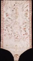
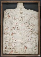
"Donnus Dominicus Vigliarolus Calaber de civitate Stili me fecit in urbe felicis Panormi 1577.", Color: red, green, and gold., Includes degrees of latitude along left edge: 60°N to 24°N., Includes six full compass roses, four half compass roses, and eight cherubs., Left portion of chart with illustration of the Pietá., and Title devised by cataloger.
Subject (Geographic):
Black Sea--Maps--Early works to 1800. and Mediterranean Sea--Maps--Early works to 1800.
Subject (Topic):
Nautical charts--Black Sea--Early works to 1800. and Nautical charts--Mediterranean Sea--Early works to 1800.
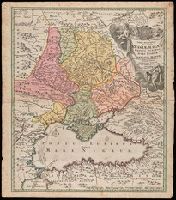
"Cum Privilegio S.C.M.", Bar scales given in wurst seu milliaria Russica, milliaria Polonica, milliaria Germanica, milliaria Gallica., Relief shown by hachures and pictorially., and Watermark. Manuscript number in upper left corner. From the Karpinski-von Wieser Map Collection.
Publisher:
[Johann Baptist Homann]
Subject (Geographic):
Black Sea--Maps--Early works to 1800., Russia--Maps--Early works to 1800., and Ukraine--Maps--Early works to 1800.
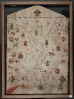
Contains eleven compass roses., Decoration: city views with banners, figures sitting on thrones, holding swords and armorial shields; animals; three fleur-de-lis., Imperfect: chipped along bottom edge, with some loss of map., Includes degrees of latitude along left edge: 25°N to 65°N., Pen-and-ink in black, red, blue and green., Portolan chart with seaport names given for all coastlines., and Title devised by cataloger.
Subject (Geographic):
Black Sea--Maps--Early works to 1800., Mediterranean Sea--Maps--Early works to 1800., and North Atlantic Ocean--Maps--Early works to 1800.
Subject (Topic):
Nautical charts--Black Sea--Early works to 1800., Nautical charts--Mediterranean Sea--Early works to 1800., and Nautical charts--North Atlantic Ocean--Early works to 1800.
Contains five compass roses., Decoration: city views with banners, figures holding swords and armorial shields., Includes inset map of the world at lower left., Pen-and-ink in black, red, blue and green., Portolan chart with seaport names given for all coastlines., and Title devised by cataloger.
Subject (Geographic):
Black Sea--Maps--Early works to 1800., Mediterranean Sea--Maps--Early works to 1800., and North Atlantic Ocean--Maps--Early works to 1800.
Subject (Topic):
Nautical charts--Black Sea--Early works to 1800., Nautical charts--Mediterranean Sea--Early works to 1800., and Nautical charts--North Atlantic Ocean--Early works to 1800.