Search
You Searched For
Search Results
- Published / Created:
- 1650?]
- Call Number:
- 1an 1650
- Container / Volume:
- BRBL_00001
- Image Count:
- 1
- Resource Type:
- Maps, Atlases & Globes
- Description:
- Latin and German.
- Subject (Topic):
- Cockaigne--Maps--Early works to 1800 and Imaginary places--Maps--Early works to 1800
- Found in:
- Beinecke Rare Book and Manuscript Library > Accurata Utopiæ tabula, das ist der neu-entdeckten Schalck-Welt, oder des so offt benannten, und doch nie erkannten Schlaraffenlandes ... / anmuthig und nutzlich vorgestelt durch Authorem Anonymum.
- Published / Created:
- 1680?]
- Call Number:
- 1an 1680
- Container / Volume:
- BRBL_00001
- Image Count:
- 1
- Resource Type:
- Maps, Atlases & Globes
- Description:
- Latin and German.
- Subject (Topic):
- Cockaigne--Maps--Early works to 1800 and Imaginary places--Maps--Early works to 1800
- Found in:
- Beinecke Rare Book and Manuscript Library > Accurata Utopiæ tabula, das ist der neu-entdeckten Schalck-Welt, oder des so offt benanten, und doch nie erkanten Schlaraffenlandes ... / anmuthig und nutzlich vorgestellt werden durch Author Anonymu.
- Creator:
- Seutter, Matthaeus, 1678-1756
- Published / Created:
- 1734?]
- Call Number:
- 71 1750C
- Container / Volume:
- BRBL_00362
- Image Count:
- 1
- Resource Type:
- Maps, Atlases & Globes
- Description:
- Appears in the author's Grosser atlas ... [between 1734 and 1750?]
- Publisher:
- s.n. ,
- Subject (Geographic):
- North America--Maps--Early works to 1800
- Subject (Name):
- Rein, Melchior, Rogg, Gottfried, 1669-1742, and Seutter, Matthaeus, 1678-1756. Grosser atlas
- Found in:
- Beinecke Rare Book and Manuscript Library > Accurata delineatio celeberrimae regionis Ludovicianae vel Gallice Louisiane ot. Canadae et Floridae adpellatione in Septemtrionali America : descriptae quae hodie nomine fluminis Mississippi vel St. Louis per colonias et navigationes Gallorum ob immensas
- Published / Created:
- 1730?]
- Call Number:
- 71 1730B
- Container / Volume:
- BRBL_00725
- Image Count:
- 1
- Resource Type:
- Maps, Atlases & Globes
- Description:
- "Gottfr. Rogg del. ; M. Rhein sc."
- Subject (Geographic):
- France--Colonies--America--Maps--Early works to 1800 and North America--Maps--Early works to 1800
- Found in:
- Beinecke Rare Book and Manuscript Library > Accurata delineatio celeberrimæ regionis Ludovicianæ vel gallice Louisiane ... in lucem edita cura et manu Matthæi Seutteri ...
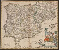
- Published / Created:
- [1780?]
- Call Number:
- 39 1780
- Container / Volume:
- BRBL_00185
- Image Count:
- 1
- Resource Type:
- Maps, Atlases & Globes
- Subject (Geographic):
- Spain--Maps--Early works to 1800
- Found in:
- Beinecke Rare Book and Manuscript Library > Accuratis sima Totius Regni Hispaniae tabula Per Gerardum a Schagen.
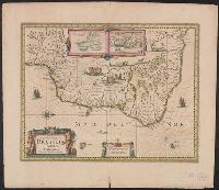
- Creator:
- Hondius, Hendrik, 1597-1651
- Published / Created:
- [1638]
- Call Number:
- 911 1630
- Container / Volume:
- BRBL_00699
- Image Count:
- 2
- Resource Type:
- Maps, Atlases & Globes
- Alternative Title:
- Baya de todos os Sanctos. and Villa d'Olinda de Pernambuco.
- Description:
- Bar scales in "Milliaria Germanica communia" and "Milliaria Gallica communia."
- Publisher:
- Henricus Hondius excudit,
- Subject (Geographic):
- Brazil--Maps--Early works to 1800
- Subject (Name):
- Hondius, Hendrik, 1597-1651. Atlas novus
- Found in:
- Beinecke Rare Book and Manuscript Library > Accuratissima Brasiliae tabula.
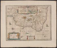
- Creator:
- Jansson, Jan, 1588-1664
- Published / Created:
- [ca. 1647]
- Call Number:
- 911 1652
- Container / Volume:
- BRBL_00668
- Image Count:
- 2
- Resource Type:
- Maps, Atlases & Globes
- Alternative Title:
- Baya de todos os Sanctos. and Villa d'Olinda de Pernambuco.
- Description:
- Bar scales in "Milliaria Germanica communia" and "Milliaria Gallica communia."
- Publisher:
- Joannes Janssonius excudit,
- Subject (Geographic):
- Brazil--Maps--Early works to 1800
- Subject (Name):
- Jansson, Jan, 1588-1664. Novus atlas. Dutch
- Found in:
- Beinecke Rare Book and Manuscript Library > Accuratissima Brasiliae tabula.
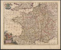
- Published / Created:
- [1700?]
- Call Number:
- 38 1700
- Container / Volume:
- BRBL_00151
- Image Count:
- 1
- Resource Type:
- Maps, Atlases & Globes
- Subject (Geographic):
- France--Maps--Early works to 1800
- Found in:
- Beinecke Rare Book and Manuscript Library > Accuratissima Galliae Tabula Vulgo Rogaume de France Per Joannem de Ram.
- Published / Created:
- [1660?]
- Call Number:
- 3615 1660
- Container / Volume:
- BRBL_00135
- Image Count:
- 1
- Resource Type:
- Maps, Atlases & Globes
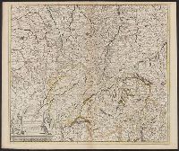
- Description:
- Includes Northeastern France, Switzerland, Southwestern Germany.
- Publisher:
- Per Theodorum Danckerum,
- Subject (Geographic):
- Rhine River--Maps--Early works to 1800
- Found in:
- Beinecke Rare Book and Manuscript Library > Accuratissima Rheni Superioris Mosae et Mosellae ...
- Creator:
- Lotter, Tobias Conrad, 1717-1777
Seutter, Matthaeus, 1678-1756
- Published / Created:
- ca. 1750
- Call Number:
- 1973 Folio 30
- Collection Title:
- [Atlas factice of 32 maps and 1 distance table, produced by the Homann Erben firm]
- Image Count:
- 2
- Publisher:
- [Matthaeus Seutter?]
- Subject (Geographic):
- Dresden (Germany : Regierungsbezirk) --Maps --Early works to 1800
- Subject (Topic):
- Atlases, German --Early works to 1800
- Collection Created:
- [Nuremberg : s.n., 1701-1760]
- Found in:
- Beinecke Rare Book and Manuscript Library > Accuratissima delineatio geographica dioecesis ac praefecturae Dresdensis [cartographic material] : cujus urbes, oppida et pagi, loca item contermina, et quae in singulis notatu digniora videntur exactiori methodo geometrice designata sistuntur / per Matt