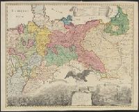
1. A Map of Central Europe. Published / Created: 1757 Call Number: 304 1757 Container / Volume: BRBL_00033 Image Count: 1 Resource Type: Maps, Atlases & Globes Description: Preliminary record. and The map (bounded by Frisia, Jutland, Prussia, Poland and extending South to include Silesia and parts of Bavaria and Lotharingia) occupies the upper half of the sheet; the lower half shows an engraved battle scence ... Subject (Geographic): Europe, Central--Maps--Early works to 1800 Found in: Beinecke Rare Book and Manuscript Library > A Map of Central Europe.