Skip to search
Skip to main content
Skip to first result
Search
You Searched For
Extent of Digitization
Completely digitized
Repository
Beinecke Rare Book and Manuscript Library
Resource Type
Maps, Atlases & Globes
Subject (Topic)
Railroads--United States--Maps
New Search
Search Results
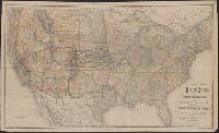
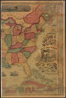
Creator:
Published / Created:
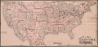
[1882?]
Call Number:
75gme 1882A
Container / Volume:
BRBL_00413
Image Count:
1
Resource Type:
Maps, Atlases & Globes
Alternative Title:
New map of the United States
Description:
Prime meridians: Greenwich and Washington. and Shows major railways west of the Mississippi River.
Publisher:
Rand, McNally,
Subject (Name):
Crofutt, George A. Crofutt's New overland tourist and Pacific coast guide and Overland Publishing Company
Subject (Topic):
Railroads--United States--Maps and Railroads--West (U.S.)--Maps
Found in:
Beinecke Rare Book and Manuscript Library > New map of the United States showing the complete railway system of the trans-Missouri country / prepared expressly for Crofutt's New overland tourist and Pacific coast guide, 1882, the Overland Publishing Company, Omaha, Neb., and Denver, Colo.
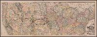
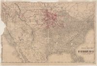
Creator:
Published / Created:
[1912]
Call Number:
80gme 1912B
Container / Volume:
BRBL_00540
Image Count:
1
Resource Type:
Maps, Atlases & Globes
Description:
Covers the northwestern states, Illinois and Wisconsin. and Relief shown by hachures.
Publisher:
Rand McNally & Co.,
Subject (Geographic):
Northwestern States--Maps
Subject (Name):
Chicago, Milwaukee & Puget Sound Railway Company--Maps, Chicago, Milwaukee, and St. Paul Railway Company--Maps, and Tacoma Eastern Railroad--Maps
Subject (Topic):
Railroads--Northwestern States--Maps and Railroads--United States--Maps
Found in:
Beinecke Rare Book and Manuscript Library > Outline map of the lines of the Chicago, Milwaukee & St. Paul Railway Company, Chicago, Milwaukee & Puget Sound Railway Company, and Tacoma Eastern Railway Company : June 30, 1912.
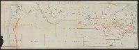
Creator:
Published / Created:
1880
Call Number:
75gme 1880B
Container / Volume:
BRBL_00413
Image Count:
2
Resource Type:
Maps, Atlases & Globes
Alternative Title:
General map of the Pennsylvania Railroad and its connections.
Description:
Inset: Round the World , Across the American Continent, via the Pennsylvania Railroad. and Text and tables on verso: Pennsylvania Railroad Great Trunk Line and U.S. Mail Route, July, 1880.
Publisher:
Allen, Lane & Scott,
Subject (Geographic):
United States--Railroads
Subject (Name):
Pennsylvania Railroad--Maps
Subject (Topic):
Railroads--United States--Maps
Found in:
Beinecke Rare Book and Manuscript Library > Pennsylvania Railroad : Great Trunk Line and U.S. Mail Route.
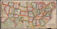
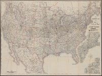
Creator:
Published / Created:
c1889.
Call Number:
75gme 1889
Container / Volume:
BRBL_00414
Image Count:
2
Resource Type:
Maps, Atlases & Globes
Alternative Title:
New official railroad map of the United States, Canada and Mexico.
Description:
Includes 9 insets., Insets: Atlantic Coast states, enlarged scale ; Important cities., Northern Canada and southern Mexico not shown., On verso: Publisher's advertisements., and Relief shown by hachures.
Publisher:
Rand McNally,
Subject (Topic):
Railroads--Canada--Maps, Railroads--Mexico, North--Maps, Railroads--North America--Maps, and Railroads--United States--Maps
Found in:
Beinecke Rare Book and Manuscript Library > Rand McNally & Co.'s new official railroad map of the United States, Canada, and Mexico.
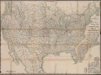
Creator:
Published / Created:
1891, c1889.
Call Number:
75gme 1891
Container / Volume:
BRBL_00414
Image Count:
2
Resource Type:
Maps, Atlases & Globes
Alternative Title:
New official railroad map of the United States, Canada and Mexico.
Description:
Includes 9 insets., Northern Canada and southern Mexico not shown., On verso: Indexes and publisher's advertisements., and Relief shown by hachures.
Publisher:
Rand McNally,
Subject (Topic):
Railroads--Canada--Maps, Railroads--Mexico, North--Maps, Railroads--North America--Maps, and Railroads--United States--Maps
Found in:
Beinecke Rare Book and Manuscript Library > Rand McNally & Co.'s new official railroad map of the United States, Canada, and Mexico.
Creator:
Published / Created:
1873
Call Number:
75 1873
Container / Volume:
BRBL_00405
Image Count:
2
Resource Type:
Maps, Atlases & Globes
Description:
Across top of map: "Panoramic view of the country between San Francisco and St. Louis.", Includes ill., text, population information, and inset of "Central America.", Prime meridians: Washington and Greenwich., and Relief shown by hachures.
Publisher:
Geo. F. Cram,
Subject (Geographic):
United States--Maps
Subject (Topic):
Railroads--United States--Maps
Found in:
Beinecke Rare Book and Manuscript Library > The Improved American Union Railroad map of the United States, British provinces, West Indies, Mexico and Central America.
Branch:v1.61.6 ,Deployed:2024-06-12T09:55:19-04:00