Skip to search
Skip to main content
Skip to first result
Search
You Searched For
Extent of Digitization
Completely digitized
Access
Public
Repository
Beinecke Rare Book and Manuscript Library
Resource Type
Maps, Atlases & Globes
Subject (Topic)
World War, 1914-1918--Maps
New Search
Search Results
Creator:
Published / Created:
[1917]
Call Number:
11hc 1919Y
Image Count:
2
Resource Type:
Maps, Atlases & Globes
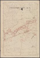
Description:
Area: from Baltic Sea to Innsbruck ; from Luxemburg to Warsaw., Imperfect. Cover wanting, some text lost., Includes index., and Shows: camps and hospitals for British prisoners, towns, rivers and roads.
Publisher:
Nisbet & Co.,
Subject (Geographic):
Austria--Maps and Germany--Maps
Subject (Topic):
World War, 1914-1918--Maps and World War, 1914-1918--Prisoners and prisons, German--Maps
Found in:
Beinecke Rare Book and Manuscript Library > Map of the main prison camps in Germany and Austria / by Mrs Pope-Hennessy.
Creator:
Published / Created:
[1914?]
Call Number:
11hcf 1919E-17
Image Count:
1
Resource Type:
Maps, Atlases & Globes
Alternative Title:
Europe 1:1,000,000, G.S.G.S. ; no. 2758, and GSGS (Series) ; no. 2758.
Description:
Includes index to adjoining sheets, index to boundaries, and pronunciation glossary. and Inscription: C[harles] Seymour.
Publisher:
Ordnance Survey,
Subject (Geographic):
Italy--Maps
Subject (Name):
Seymour, Charles,--1885-1963--Autograph
Subject (Topic):
World War, 1914-1918--Maps
Found in:
Beinecke Rare Book and Manuscript Library > Milano : North L. 32. / compiled at the Royal Geographical Society under the direction of the Geographical Section; drawn and printed by Ordnance Survey.
Creator:
Call Number:
11hcf 1919E-23
Container / Volume:
BRBL_00010ZA
Image Count:
1
Resource Type:
Maps, Atlases & Globes
Alternative Title:
Europe 1:1,000,000, G.S.G.S. ; no. 2758, and GSGS (Series) ; no. 2758.
Description:
Elevation shown by color., Includes index to adjoining sheets, index to boundaries, and pronunciation glossary., and Sheet "North L-33, Triest," from same series, attached. Label pasted at foot of sheet showing "Treaty of London line" and "Recommended southern
Subject (Geographic):
Italy--Maps
Subject (Name):
Great Britain. Ordnance Survey
Subject (Topic):
World War, 1914-1918--Maps
Found in:
Beinecke Rare Book and Manuscript Library > Milano [cartographic material] : North L. 32. / compiled at the Royal Geographical Society under the direction of the Geographical Section; drawn and printed by Ordnance Survey.
Creator:
Published / Created:
c1914.
Call Number:
11hc 1914C
Container / Volume:
BRBL_00010A
Image Count:
1
Resource Type:
Maps, Atlases & Globes
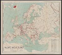
Description:
Includes table showing area and populations of the European powers., Indicates fortified towns, military headquarters, naval stations, railroads; concentric circl, Inset of location map of the world with Europe highlighted in red., and Prime meridian: Greenwich.
Publisher:
General Drafting Co.,
Subject (Geographic):
Europe--Maps
Subject (Topic):
World War, 1914-1918--Europe--Maps and World War, 1914-1918--Maps
Found in:
Beinecke Rare Book and Manuscript Library > Military map of Europe [cartographic material] / compiled from the most authentic sources.
Published / Created:
1918?]
Call Number:
38hc 1918E
Container / Volume:
BRBL_00172
Image Count:
1
Resource Type:
Maps, Atlases & Globes
Description:
Ms. annotations in black and red ink.
Publisher:
s.n.,
Subject (Geographic):
Lorraine (France)--Military maps
Subject (Topic):
World War, 1914-1918--France--Lorraine and World War, 1914-1918--Maps
Found in:
Beinecke Rare Book and Manuscript Library > Minenwerfer-Karte, Div. "H".
Creator:
Published / Created:
[n.d.]
Call Number:
30 1920E
Container / Volume:
BRBL_00032A
Image Count:
2
Resource Type:
Maps, Atlases & Globes
Description:
On verso: Europe in 1921, with railways. - Western fron. - Section of Maginot line fortification. - Europe air mileage distances. - Unification of Germany, 1866-1871. - Text., Shows 1914 boundarie, and Title on cover when folded: Rand McNally war map of Europe.
Subject (Geographic):
Europe--Maps
Subject (Topic):
World War, 1914-1918--Maps
Found in:
Beinecke Rare Book and Manuscript Library > Rand McNally standard map of Europe.
Creator:
Published / Created:
1916
Call Number:
11hcf 1919E-16
Image Count:
1
Resource Type:
Maps, Atlases & Globes
Alternative Title:
Europe 1:1,000,000, G.S.G.S. ; no. 2758, and GSGS (Series) ; no. 2758.
Description:
Includes index to adjoining sheets, index to boundaries, and pronunciation glossary. and Inscription: C[harles] Seymour.
Publisher:
Ordnance Survey,
Subject (Geographic):
Italy--Maps
Subject (Name):
Seymour, Charles,--1885-1963--Autograph
Subject (Topic):
World War, 1914-1918--Maps
Found in:
Beinecke Rare Book and Manuscript Library > Roma : North K 33. / compiled at the Royal Geographical Society under the direction of the Geographical Section; drawn and printed by Ordnance Survey.
Creator:
Published / Created:
[1914]
Call Number:
30an 1914C
Container / Volume:
BRBL_00037A
Image Count:
1
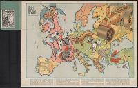
Resource Type:
Maps, Atlases & Globes
Description:
Caricature map., Countries are represented by human and animal caricatures to depict political issues., and Includes text.
Publisher:
W. Nölting,
Subject (Geographic):
Europe--Maps and Europe--Politics and government--Maps
Subject (Topic):
World War, 1914-1918--Maps
Found in:
Beinecke Rare Book and Manuscript Library > Satyrische Europa Karte, Weltkrieg 1914 / Zeichnung u. Entwurf, E. Zimmermann.
Creator:
Published / Created:
[191-]
Call Number:
30 191X
Container / Volume:
BRBL_00032
Image Count:
2
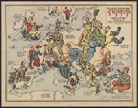
Resource Type:
Maps, Atlases & Globes
Alternative Title:
Hark! hark! the dogs do bark!
Description:
Cover title., Includes text., and National wartime attitudes are represented by caricatures of dogs and people.
Publisher:
G.W. Bacon & Co.,
Subject (Geographic):
Europe--Maps
Subject (Name):
Emanuel, Walter, 1869-1915
Subject (Topic):
World War, 1914-1918--Caricatures and cartoons and World War, 1914-1918--Maps
Found in:
Beinecke Rare Book and Manuscript Library > Serio-comique map of Europe at war : hark! hark! the dogs do bark! / designed and printed by Johnson & Riddle Co. ; with a note by Walter Emanuel.
Creator:
Published / Created:
1915
Call Number:
30 1915G
Container / Volume:
BRBL_00032A
Image Count:
2
Resource Type:
Maps, Atlases & Globes
Description:
"Zensur Altona 603.", Caricature map., Caricatures represent international relations., and Includes text.
Publisher:
L. Gräfe,
Subject (Geographic):
Europe--Maps
Subject (Topic):
International relations--20th century--Maps, World War, 1914-1918--Caricatures and cartoons, and World War, 1914-1918--Maps
Found in:
Beinecke Rare Book and Manuscript Library > Sommerschau über Europa 1915 : erweiterte Massstab, 3 gegen 8 / A.K. gez. u. lith.
Branch:v1.61.8 ,Deployed:2024-06-20T11:15:04-04:00