Skip to search
Skip to main content
Skip to first result
Search
You Searched For
Extent of Digitization
Completely digitized
Repository
Beinecke Rare Book and Manuscript Library
Resource Type
Maps, Atlases & Globes
New Search
Search Results
Published / Created:
1770
Call Number:
785 1770
Container / Volume:
BRBL_00513
Image Count:
1
Resource Type:
Maps, Atlases & Globes
Description:
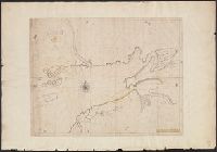
From Streeter Collection -cat. no. 1132., Legend: To his Most Excellent Majesty George the IIID King of Great Britain, &c. &c. &c. This map is most humbly dedicated by most humble obidient & dutiful subject, John Collet., and This large scale map locates the re
Publisher:
S. Hooper,
Subject (Geographic):
North Carolina--Maps--Early works to 1800
Found in:
Beinecke Rare Book and Manuscript Library > A Compleat Map of North-Carolina from an actual Survey. By Capnt. [John A. ] Collet, Governor of Fort Johnson, Engraved by I. Bayly. Published according to Act of Parliament May the 1st. 1770, by S. Hooper Nọ 25 Ludgate Hill, London.
Branch:v1.61.6 ,Deployed:2024-06-12T09:55:36-04:00