Geological and Geographical Survey of the Territories (U.S.)
Published / Created:
1876?]
Call Number:
836ca G825 1873
Container / Volume:
BRBL_00593
Image Count:
1
Resource Type:
Maps, Atlases & Globes
Description:
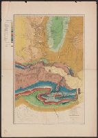
"Vertical distance between contour lines 250 feet.", Appears in Powell's Atlas accompanying the report on the geology of a portion of the Uinta Mountains and a region of country adjacent thereto. New York: Julius Bien, lith., l876., In top margin: Map B., and Relief shown by contours.
Publisher:
Julius Bien, lith.?,
Subject (Geographic):
Green River (Wyo.-Utah)--Maps
Subject (Name):
Bishop, F. M, De Motte, H. C, Graves, W. H, Kübel, S. J, Powell, John Wesley, 1834-1902, and Powell, John Wesley, 1834-1902. Atlas accompanying the report on the geology of a portion of the Uinta Mountai
Geological and Geographical Survey of the Territories (U.S.)
Published / Created:
1876?]
Call Number:
836g G825 1873
Container / Volume:
BRBL_00593
Image Count:
1
Resource Type:
Maps, Atlases & Globes
Description:
"Vertical distance between contour lines 250 feet.", Appears in Powell's Atlas accompanying the report on the geology of a portion of the Uinta Mountains and a region of country adjacent thereto. New York: Julius Bien, lith., l876., In top margin: Map A., and Relief shown by contours.
Publisher:
Julius Bien, lith.?,
Subject (Geographic):
Green River (Wyo.-Utah)--Maps
Subject (Name):
Bishop, F. M, De Motte, H. C, Graves, W. H, Kübel, S. J, Powell, John Wesley, 1834-1902, and Powell, John Wesley, 1834-1902. Atlas accompanying the report on the geology of a portion of the Uinta Mountai
Subject (Topic):
Copper ores--Green River Watershed (Wyo.-Utah)--Maps, Forests and forestry--Green River Watershed (Wyo.-Utah)--Maps, Irrigation--Green River Watershed (Wyo.-Utah)--Maps, and Silver ores--Green River Watershed (Wyo.-Utah)--Maps
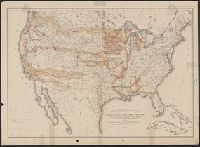
"For explanation see chapter on "Land Grants in aid of Internal Improvements.", "Julius Bien, Lithographer.", "The base chart was engraved for the Statistical Atlas of the United States.", and "To accompany report on the lands of the arid region of the U.S."
Publisher:
Dept. of the Interior,
Subject (Geographic):
United States--Maps
Subject (Name):
Geographical and Geological Survey of the Rocky Mountain Region (U.S.) and Powell, John Wesley, 1834-1902