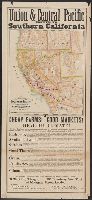
Map of the Southern Pacific Railroad and connections and Union & Central Pacific route to Southern California.
Description:
Above map: Union & Central Pacific route to Southern California., At bottom of text: Omaha, March 1, 1877., At bottom of text: Printed at the Omaha Republican Steam Book and Job Printing House, Omaha, Neb., Below map title: June 1875., Below map: Matthews & Warren Com'l Adv. Printing House, Buffalo, N.Y., Includes text advertising Southern California for settlement and travel., and Relief shown by shading.
Publisher:
s.n.,
Subject (Name):
Matthews & Warren and Southern Pacific Railroad Company--Maps
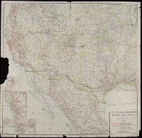
Copyright: Southern Pacific Co., Covers states west of the Mississippi River and area in Mexico north of Mexico City., Insets: Portland and vicinity -- San Francisco and vicinity -- Los Angeles and vicinity., and Library's copy imperfect: Part of Portland inset torn away.
Publisher:
Rand McNally & Co.,
Subject (Name):
Southern Pacific Railroad Company--Maps
Subject (Topic):
Railroads--Mexico--Maps and Railroads--West (U.S.)--Maps