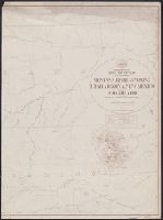
"Drawn by A.F. Dinsmore.", "The service on this diagram brought up to date of [blank space].", Date below title block: 1878., Prime meridian: Washington, D.C., and Relief shown by hachures.
Publisher:
s.n.,
Subject (Geographic):
West (U.S.)--Maps
Subject (Name):
Dinsmore, A. F and United States. Post Office Dept
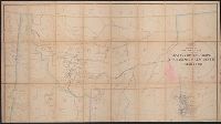
"The service on this diagram brought up to date of March 1, 1882.", Date below title block: 1878., Label on backing: Post route map of the territory of Montana., Library missing bottom half of map; label on backing signed, "Jas. A, and Prime meridian: Washington.
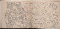
Territory of north western America, ceded by Russia to the United States, 1868.
Description:
Also shows principal mail routes and railroads., Dakota Territory appears reduced to present area (1868), but before it was divided into North Dakota and South Dakota (1889)., Includes inset of "The territory of north western America, ceded by Russia to the United States, 1868" (scale 1:9,000,000)., Library's copy missing bottom right sheet and top two sheets are joined. Bottom left sheet blind stamped, "Boston Public Library.", Relief shown by hachures and spot heights., and Title devised by cataloger.
Publisher:
s.n.,
Subject (Geographic):
West (U.S.)--Maps
Subject (Topic):
Military departments and divisions--West (U.S.)--Maps, Postal service--West (U.S.)--Maps, and Railroads--West (U.S.)--Maps