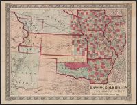
Johnson's new railroad and county copper plate map of Kansas gold region and the Great West, from the latest and best authorities, New, and New rail road and county copper plate map of Kansas gold region and the Great West, from the latest and best authorities
Description:
"Entered according to act of Congress in the year 1859 by A.J. Johnson in the clerks office of the district court of the United States for the southern district of New, Includes notes., Prime meridian: Washington., and Relief shown by hachures and spot heights.
Publisher:
Johnson & Browning,
Subject (Geographic):
Kansas--Maps and West (U.S.)--Maps
Subject (Name):
Johnson & Browning
Subject (Topic):
Colorado--Gold discoveries--Maps, Gold mines and mining--Colorado--Maps, and Railroads--West (U.S.)--Maps
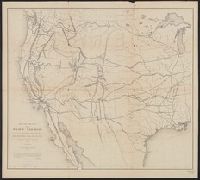
"This map is a hurried compilation of all the authentic surveys and is designed to exhibit the relations of the different routes to each other.", Appears in 33d Cong., 1st Sess., House Ex. Doc. 129, Serial 736., and Relief shown by hachures and spot heights.
Publisher:
Lith. of J. Bien,
Subject (Name):
Bien, Julius, 1826-1909
Subject (Topic):
Pacific railroads--Maps and Railroads--West (U.S.)--Maps
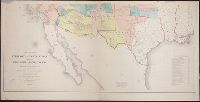
Includes "Note" and "Authorities.", Incorporates note and surveys added after Jan. 8, 1858., Relief shown by hachures and spot heights., and Shows Indian tribal locations, military posts, routes and dates of expeditions and surveys.
Publisher:
War Dept.,
Subject (Geographic):
West (U.S.)--Maps
Subject (Name):
Siebert, Selmar and United States. War Dept
Subject (Topic):
Pacific railroads--Explorations and surveys--Maps and Railroads--West (U.S.)--Maps