
You Searched For
1 - 6 of 6
Search Results
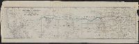
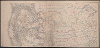
2.

- Creator:
- Palmer, William Jackson, 1836-1909
- Published / Created:
- 1868]
- Call Number:
- 80gme 1869A
- Container / Volume:
- BRBL_00538
- Image Count:
- 1
- Resource Type:
- Maps, Atlases & Globes
- Description:
- Includes distance tables., Relief shown by hachures., and Shows drainage, cities and towns, forts, military and Indian reservations, wagon roads, trails, routes of exploration, and the railroad network indicating finished, unfinished, and connecting lines.
- Publisher:
- s.n.,
- Subject (Name):
- Gedney, J. F and Southern Continental Railroad--Maps
- Subject (Topic):
- Railroads--West (U.S.)--Maps
- Found in:
- Beinecke Rare Book and Manuscript Library > Map of the route of the Southern Continental R.R. with connections from Kansas City Mo., Ft. Smith Ark. and Shreveport La., giving a general view of the recent surveys of the Kansas Pacific Railway Co., across the continent / made in 1867 & 1868, under th
3.
- Creator:
- Palmer, William Jackson, 1836-1909
- Published / Created:
- 1868]
- Call Number:
- 80gme 1868
- Container / Volume:
- BRBL_00538
- Image Count:
- 1
- Resource Type:
- Maps, Atlases & Globes
- Description:
- Includes distance table., Relief shown by hachures., and Shows drainage, cities and towns, forts, military and Indian reservations, wagon roads, trails, routes of exploration, and the railroad network indicating finished, unfinished, and connecting lines.
- Publisher:
- s.n.,
- Subject (Name):
- Gedney, J. F and Southern Continental Railroad--Maps
- Subject (Topic):
- Railroads--West (U.S.)--Maps
- Found in:
- Beinecke Rare Book and Manuscript Library > Map of the route of the Southern Continental R.R. with connections from Kansas City, Mo., Ft. Smith, Ark. and Shreveport, La. : giving a general view of recent surveys of the Kansas Pacific Railway Co. across the continent / made in 1867 & 1868 under the
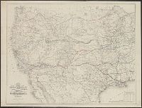
- Creator:
- Freyhold, Edward
- Published / Created:
- [1868]
- Call Number:
- 80 1868
- Container / Volume:
- BRBL_00535
- Image Count:
- 4
- Resource Type:
- Maps, Atlases & Globes
- Description:
- Includes list of "Authorities" and inset "Territory of Alaska" (scale 1:9,000,000)., Relief shown by hachures and spot heights., and Shows routes and dates of expeditions and surveys.
- Publisher:
- War Dept.,
- Subject (Geographic):
- West (U.S.)--Maps
- Subject (Name):
- United States. War Dept and Warren, Gouverneur Kemble, 1830-1882
- Subject (Topic):
- Pacific railroads--Explorations and surveys--Maps and Railroads--West (U.S.)--Maps
- Found in:
- Beinecke Rare Book and Manuscript Library > Territory of the United States from the Mississippi River to the Pacific Ocean : originally prepared to accompany the reports of the explorations for a Pacific railroad route / compiled from authorized explorations and other reliable data by G. K. Warren
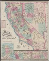
- Creator:
- Nell, Louis
- Published / Created:
- 1868
- Call Number:
- 844gme 1868
- Container / Volume:
- BRBL_00619
- Image Count:
- 1
- Resource Type:
- Maps, Atlases & Globes
- Alternative Title:
- Map of the city of San Francisco, California., Map of the Great National Pacific Railroads., and Topographical railroad and county map of the states of California and Nevada
- Description:
- "Entered according to act of Congress A.D. 1868 by Frey & Nell in the clerks office of the district court of the United States for the southern district of New York." and Includes insets of "Map of the city of San Francisco, California" and "Map of the Great National Pacific Railroads," distance list, and difference of time chart.
- Publisher:
- A.C. Frey & Co. ; and General agents for California, A. Roman & Co.,
- Subject (Geographic):
- California--Maps, Nevada--Maps, and San Francisco (Calif.)--Maps
- Subject (Name):
- A. Roman & Co, A.C. Frey & Co, and Ferd. Mayer & Co
- Subject (Topic):
- Railroads--West (U.S.)--Maps
- Found in:
- Beinecke Rare Book and Manuscript Library > Topographical railroad & county map of the states of California and Nevada : compiled from the latest explorations and other official information / by L. Nell.
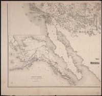
- Published / Created:
- between 1868 and 1889?]
- Call Number:
- 80 1900
- Container / Volume:
- BRBL_00536
- Image Count:
- 2
- Resource Type:
- Maps, Atlases & Globes
- Alternative Title:
- Territory of north western America, ceded by Russia to the United States, 1868.
- Description:
- Also shows principal mail routes and railroads., Dakota Territory appears reduced to present area (1868), but before it was divided into North Dakota and South Dakota (1889)., Includes inset of "The territory of north western America, ceded by Russia to the United States, 1868" (scale 1:9,000,000)., Library's copy missing bottom right sheet and top two sheets are joined. Bottom left sheet blind stamped, "Boston Public Library.", Relief shown by hachures and spot heights., and Title devised by cataloger.
- Publisher:
- s.n.,
- Subject (Geographic):
- West (U.S.)--Maps
- Subject (Topic):
- Military departments and divisions--West (U.S.)--Maps, Postal service--West (U.S.)--Maps, and Railroads--West (U.S.)--Maps
- Found in:
- Beinecke Rare Book and Manuscript Library > [Map of western United States showing military departments].