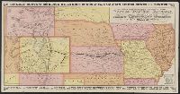
Advertisements, text, and timetables on verso., Includes distance table and text., Latest year mentioned in text on verso: 1877., and Relief shown pictorially.
Publisher:
s.n.,
Subject (Name):
Kansas Pacific Railway Company, Kansas Pacific Railway Company--Maps, and Woodward, Tiernan, and Hale
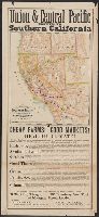
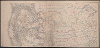
Map of the Southern Pacific Railroad and connections and Union & Central Pacific route to Southern California.
Description:
Above map: Union & Central Pacific route to Southern California., At bottom of text: Omaha, March 1, 1877., At bottom of text: Printed at the Omaha Republican Steam Book and Job Printing House, Omaha, Neb., Below map title: June 1875., Below map: Matthews & Warren Com'l Adv. Printing House, Buffalo, N.Y., Includes text advertising Southern California for settlement and travel., and Relief shown by shading.
Publisher:
s.n.,
Subject (Name):
Matthews & Warren and Southern Pacific Railroad Company--Maps
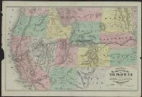
New trans-continental map of the Pacific R.R. and routes of overland travel to Colorado, Nebraska, the Black Hills, Utah, Idaho, Nevada, Montana, California and the Pacific coast
Description:
"Entered according to act of Congress in the year 1876 by H.T. Williams ...", Advertisements and text on verso., In lower margin: Am. Photo-Lithographic Co. N.Y. (Osborne's Process)., Relief shown by, and Shows completed and projected railroads and stage routes.
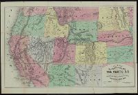
New trans-continental map of the Pacific R.R. and routes of overland travel to Colorado, Nebraska, the Black Hills, Utah, Idaho, Nevada, Montana, California, and the Pacific coast
Description:
"Entered according to act of Congress in the year 1877 by H.T. Williams ...", Advertisements, time tables, fare schedules, and text on verso., and Relief shown by hachures.
Territory of north western America, ceded by Russia to the United States, 1868.
Description:
Also shows principal mail routes and railroads., Dakota Territory appears reduced to present area (1868), but before it was divided into North Dakota and South Dakota (1889)., Includes inset of "The territory of north western America, ceded by Russia to the United States, 1868" (scale 1:9,000,000)., Library's copy missing bottom right sheet and top two sheets are joined. Bottom left sheet blind stamped, "Boston Public Library.", Relief shown by hachures and spot heights., and Title devised by cataloger.
Publisher:
s.n.,
Subject (Geographic):
West (U.S.)--Maps
Subject (Topic):
Military departments and divisions--West (U.S.)--Maps, Postal service--West (U.S.)--Maps, and Railroads--West (U.S.)--Maps