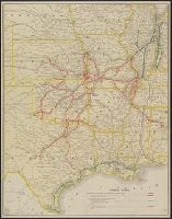
Covers area defined by Nebraska and Iowa to the north and Texas on the south; and the Kansas-Colorado border to the west and Alabama to the east., In lower left: Parker Engraving Co., St. Louis, Mo., and Shows St. Louis & San Francisco Railroad and auxiliary li
Publisher:
Parker Engraving Co.?],
Subject (Name):
Chicago & Eastern Illinois Railroad Company--Maps, Houston & Texas Central Railway Company--Maps, New Orleans, Texas & Mexico Railroad Company--Maps, Parker Eng. Co, and St. Louis-San Francisco Railway Company--Maps
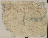
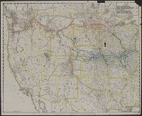
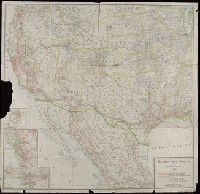
Copyright: Southern Pacific Co., Covers states west of the Mississippi River and area in Mexico north of Mexico City., Insets: Portland and vicinity -- San Francisco and vicinity -- Los Angeles and vicinity., and Library's copy imperfect: Part of Portland inset torn away.
Publisher:
Rand McNally & Co.,
Subject (Name):
Southern Pacific Railroad Company--Maps
Subject (Topic):
Railroads--Mexico--Maps and Railroads--West (U.S.)--Maps