Map showing the communication of the lakes and the rivers between Lake Superior and Slave Lake in North America
Description:
"Gent. Mag. March 1790, Pl. I, p. 197" in upper right hand corner., Mounted on linen. Sheet measures 20.7 x 24.3 cm. Cross Collection no. 178., Prime meridian: London., and Relief shown by hachures.
Publisher:
s.n., 1790?]
Subject (Geographic):
Canada--Maps--Early works to 1800 and North America--Maps--Early works to 1800
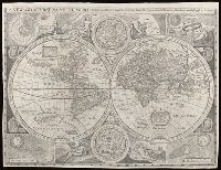
New and accurat map of the world and New and accurate map of the world
Description:
Attributed to Robert Walton; based on a map by John Speed., From Denis Petau's History of the world (1659)., Includes insets of "The heavens and elements," "The eclipse of the sunn," "A figure of the spheare," and "The eclipse of the moone," 2 celestial hemispheres, historical notes, and illustrations., Relief shown pictorially., Shows California as an island., and Watermark.
Subject (Name):
Petau, Denis, 1583-1652 and Speed, John, 1552?-1629
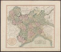
Inset illustration of the Reichstag of Holy Roman Empire, with title: The General Diet of the Empire, or it's Parliament.
Subject (Geographic):
Europe, Central--Maps--Early works to 1800, Germany--Maps--Early works to 1800, Hungary--Maps--Early works to 1800, Romania--Maps--Early works to 1800, and Switzerland--Maps--Early works to 1800
Subject (Name):
Holy Roman Empire.--Reichstag and Hughes, Thomas Lowe,--1925---Ownership
English text on verso entitled: The description of the kingdom of Tartary, p. 39-40 (signature: V)., Illustrations on left border: A. Samoged -- Tartar genteel woman -- A Tartar -- Tartar country woman., Illustrations on right border: Samoged woman -- Tartar gentleman -- Tartar woman -- Tartar country man., Illustrations on top border: Astrakhan -- Samarkand -- Cambalu -- The House in Nova Zemla., Map folio 39 from: The theatre of the Empire of Great Britaine ... as also a prospect of the most famous parts of the world / John Speed. London : Thomas Bassett & Richard Chiswell, 1676., Map of Tartary [i.e. Mongolia] to the north of China controlled by marauding Mongols in the 13th-14th centuries. The map shows its provinces and cities stretching north from the Himalayas, west to eastern Europe and north of Chinae Regni Pars [i.e. China] and Corea Isle [i.e. Korea]. One feature is the Great Wall of China along the Chinese border on the lower right side of the map. There are many decorative features including along the top of the map pictorial scenes of the cities of Astrakhan, Samarkand and Cambalu, as well as an illustration of a "house in Nova Zemla". Left and right borders eight colourful illustrations of ethnic costumes from some of the peoples of Tartary., Relief shown pictorially., Text at top centre of map reviewing the discovery of Nova Zembla [i.e. the archipelago Novaya Zemlya] by the Dutch explorer William Hollander in 1594-96., and Watermark.