Decorated with sea monsters, mermaids, exotic animals, and cannibals, this wood cut map provides a marked contrast to the simplistic diagrams considered the earliest printed world maps. While the latter presented a world view based in Judeo-Christian theo
Alternative Title:
Typus cosmographicus universalis and Typvs cosmographicvs vniversalis
Description:
Appears in Johann Huttich's Novus orbis regionum. Basel. 1532. and Relief shown pictorially.
Publisher:
[publisher not identified],
Subject (Name):
Holbein, Hans, 1497-1543 and Huttich, Johann, 1480?-1544. Novus orbis regionum.
Afheeldinghe der custen des landts Guinea, Manicongo, ende Angôla, ende voorts tot voorby de C. de boa esperança and Delineatio orarum maritimarum, terrae vulgo indigetatae terra do Natal item Sofalae, Mozambicae & Melindae ...
Description:
Appears in the author's, Companion map to Delineatio orarum maritimarum, terrae vulgo indigetatae terra do Natal item Sofalae, Mozambicae & Melindae ..., Has watermark., Relief shown pictorially., and Title in Latin and Dutch. Place names in Latin and Portuguese.
Publisher:
Arnold Florent van Langren,
Subject (Geographic):
Africa, Southern--Maps--Early works to 1800
Subject (Name):
Langren, Arnold Florent van, 1580-1644 and Linschoten, Jan Huygen van, 1563-1611. Itinerario, voyage ofte schipvaert van Jan Huygen van Linschoten naer Oost ofte Portugaels Indien
Subject (Topic):
Coasts--Africa, Southern--Maps--Early works to 1800
Afheeldinghe der custen des landts Guinea, Manicongo, ende Angôla, ende voorts tot voorby de C. de boa esperança and Delineatio orarum maritimarum, terrae vulgo indigetatae terra do Natal item Sofalae, Mozambicae & Melindae ...
Description:
Appears in the author's Itinerario, voyage ofte schipvaert van Jan Huygen van Linschoten naer Oost ofte Portugaels Indien., Includes views of Ascension Island and Sain, Relief shown pictorially., and Title in Latin and Dutch. Place names in Latin and Portuguese.
Publisher:
Arnold Florent van Langren,
Subject (Geographic):
Africa, Southern--Maps--Early works to 1800
Subject (Name):
Langren, Arnold Florent van, 1580-1644 and Linschoten, Jan Huygen van, 1563-1611. Itinerario, voyage ofte schipvaert van Jan Huygen van Linschoten naer Oost ofte Portugaels Indien
Subject (Topic):
Coasts--Africa, Southern--Maps--Early works to 1800
Possibly from Münster's 1545 edition of Ptolemy's Geographia [Basel : Heinrich Petri, 1545]. and Sheet measures 31.5 x 39 cm. Stamp on verso: Karpinski-von Wieser Map Collection.
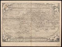
"Quid ei potest videri magnum in rebus humanis, cui aeternitas omnis, totiusque mundi nota sit magnitudo. Cicero"., Cross collection no. 7. Label on verso with manuscript number "101/58.", From Ortelius's Theatrum orbis terrarum., German text on verso, with caption title "Die gantsche Welt" and signature l., and Relief shown pictorially.
Publisher:
[Abraham Ortelius],
Subject (Name):
Hogenberg, Frans, approximately 1539-1590, engraver. and Ortelius, Abraham, 1527-1598. Theatrum orbis terrarum.
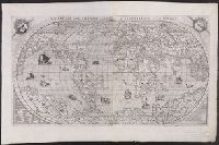
Vniversale descrittione di tvtta la terra conoscivta fin qvi
Description:
From: [Italian composite atlases]., Map is made from a new copper plate which is a close copy of Paolo Forlani's world map, which Forlani copied from Giacomo Gastaldi's prototype world map of 1546., Relief shown pictorially., and There are winged cherub heads in the top two spandrels.
Publisher:
Donato Bertelli,
Subject (Name):
Forlani, Paolo and Gastaldi, Giacomo, ca. 1500-ca. 1565
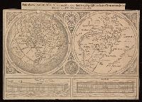
Universaltafel des situs Asiae, Africae und Europae, samt der gelegenhäit des lands Eden, wie auch eine delineatio der arch Noe bäides im grund und auftitz
Description:
Caption title., Includes two images of Noah's ark., One partial hemisphere map of Europe, Africa, and Asia and one map of the Biblical Middle East., and Relief shown pictorially.
Publisher:
[publisher not identified],
Subject (Geographic):
Middle East--Maps--Early works to 1800. and Northern Hemisphere--Maps--Early works to 1800.
Subject (Topic):
Bible.--Old Testament--Geography--Maps--Early works to 1800.
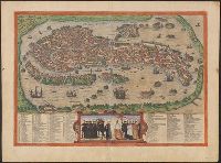
"Cvm privilegio"., From Braun and Hogenberg's Civitates orbis terrarum, 1572., Includes index of city features and a depiction of Venetian figures., Latin, Italian., No. on verso: 43., Relief shown pictorially., and Sheet measures 40 x 54 cm. Ms. note on verso. dgv
Publisher:
s.n.,
Subject (Geographic):
Venice (Italy)--Maps--Early works to 1800
Subject (Name):
Hogenberg, Frans, approximately 1539-1590. Civitates Orbis Terrarum. Latin