Skip to search
Skip to main content
Skip to first result
Search
You Searched For
"Missouri"
Extent of Digitization
Completely digitized
Resource Type
Maps, Atlases & Globes
New Search
Search Results
Creator:
Published / Created:
[1941]
Call Number:
816gmb 1941A
Container / Volume:
BRBL_00564
Image Count:
2
Resource Type:
Maps, Atlases & Globes
Alternative Title:
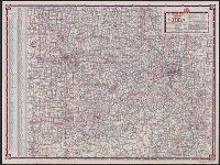
Highway map, Missouri
Description:
3 maps, ill., and text on verso., At head of title: Standard Oil Company (Indiana), In lower right: W.3712., Indexed., and Relief shown by spot heights.
Publisher:
Rand McNally,
Subject (Geographic):
Missouri --Maps
Subject (Name):
Standard Oil Company (Indiana)
Subject (Topic):
Roads--Missouri --Maps
Found in:
Beinecke Rare Book and Manuscript Library > Road map, Missouri / compliments of Standard Oil Company of Indiana.
Creator:
Published / Created:
[1929]
Call Number:
816gmb 1929
Container / Volume:
BRBL_00564
Image Count:
2
Resource Type:
Maps, Atlases & Globes
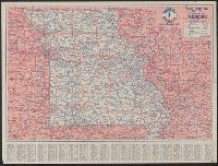
Alternative Title:
1929 road map of Missouri
Description:
In lower right: C-134 J.C., Indexed., and Text and col. ill. on verso.
Publisher:
H.M. Gousha,
Subject (Geographic):
Missouri --Maps
Subject (Name):
Continental Oil Company
Subject (Topic):
Roads--Missouri --Maps
Found in:
Beinecke Rare Book and Manuscript Library > Continental Oil Co. official road map, Missouri / compliments of Continental Oil Co.
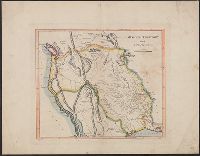
Creator:
Published / Created:
1814]
Call Number:
80 1814D
Container / Volume:
BRBL_00532
Image Count:
1
Resource Type:
Maps, Atlases & Globes
Description:
Shows boundaries of Missouri Territory.
Publisher:
Mathew Carey?,
Subject (Geographic):
Prairie Provinces--Maps and West (U.S.)--Maps
Subject (Name):
Bower, J. (John) and Lewis, Samuel, 1753 or 1754-1822
Found in:
Beinecke Rare Book and Manuscript Library > Missouri Territory formerly Louisiana / Lewis, del. ; Bower, sc.
Creator:
Missouri . Board of Immigration
Published / Created:
c1879.
Call Number:
816 1879A
Container / Volume:
BRBL_00561
Image Count:
1
Resource Type:
Maps, Atlases & Globes
Description:
"Copyrighted 1879, by H.R. Page.", Library's copy mounted on cloth., and Prime meridians: Washington and Greenwich.
Publisher:
Issued by the State Board of Immigration,
Subject (Name):
Page, H. R
Found in:
Beinecke Rare Book and Manuscript Library > Map of the state of Missouri.
Creator:
Published / Created:
1865
Call Number:
816ca 1865
Container / Volume:
BRBL_00563
Image Count:
1
Resource Type:
Maps, Atlases & Globes
Description:
"Compiled from the U.S. Surveys, geological reports and personal reconnoisance.", Includes text., and Relief shown by hachures.
Publisher:
J.B. Lippincott & Co. ; and N.H. Parker,
Subject (Name):
J.B. Lippincott Company and Mackenzie and Gardner Lithographers
Subject (Topic):
Geology--Missouri --Maps
Found in:
Beinecke Rare Book and Manuscript Library > Parker's geological map of the state of Missouri : showing the location of the principal deposits of iron, lead, zinc, tin, copper, diamonds, gold, silver, platina, nickel, manganese, alabaster, kaolin, coal, oil springs, &c. / by Nathan H. Parker ; Macke
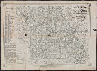
Published / Created:
1914?]
Call Number:
816gme Oz1 1914
Container / Volume:
BRBL_00564
Image Count:
1
Resource Type:
Maps, Atlases & Globes
Description:
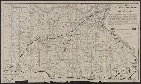
"F.J. Deicke, General Agent Passenger Department, Frisco Lines, 900 Olive St., Frisco Bldg., St. Louis, Mo.", In lower right: 5-15-'14., and Includes text.
Publisher:
s.n.,
Subject (Name):
Parker Eng. Co, St. Louis-San Francisco Railway Company, and St. Louis-San Francisco Railway Company--Maps
Subject (Topic):
Railroads--Missouri --Maps
Found in:
Beinecke Rare Book and Manuscript Library > Map of the Ozark country along the Frisco lines in Missouri / Parker-eng. co., St. Louis, Mo.
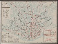
Creator:
Published / Created:
c1944.
Call Number:
816 Sa24 1944
Container / Volume:
BRBL_00562
Image Count:
2
Resource Type:
Maps, Atlases & Globes
Alternative Title:
St. Louis and vicinity
Description:
Includes text and inset., Indexes, text, and ill. on verso., Oriented with north toward upper right., and Panel title.
Publisher:
Herman W. Gross,
Subject (Geographic):
Saint Louis (Mo.)--Maps
Subject (Name):
Gross, Herman W
Subject (Topic):
Local transit--Missouri --Saint Louis
Found in:
Beinecke Rare Book and Manuscript Library > Guide-map St. Louis and vicinity / St. Louis Public Service Company.
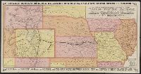
Published / Created:
1877?]
Call Number:
80gme 1877B
Container / Volume:
BRBL_00539
Image Count:
2
Resource Type:
Maps, Atlases & Globes
Alternative Title:
Kansas Pacific Railway
Description:
Advertisements, text, and timetables on verso., Includes distance table and text., Latest year mentioned in text on verso: 1877., and Relief shown pictorially.
Publisher:
s.n.,
Subject (Name):
Kansas Pacific Railway Company, Kansas Pacific Railway Company--Maps, and Woodward, Tiernan, and Hale
Subject (Topic):
Railroads--West (U.S.)--Maps
Found in:
Beinecke Rare Book and Manuscript Library > A geographically correct map of the Kansas Pacific Railway : showing the only direct route to Denver and all the popular Rocky Mountain resorts, also to the Black Hills country and the famous San Juan mines in Colorado / Woodward, Tiernan & Hale, map engr
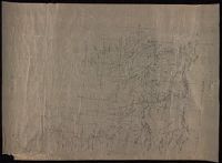
Creator:
Published / Created:
before 1835
Call Number:
WA MSS S-2687
Collection Title:
Washington Hood papers
Container / Volume:
5 Broadside
Image Count:
1
Resource Type:
Maps, Atlases & Globes
Description:
and Missouri .
Subject (Geographic):
Iowa--History--Maps, Nebraska--History--Maps, and West (U.S.)--Surveys
Subject (Name):
Hood, Washington, 1808-1840, United States.--Army.--Corps of Topographical Engineers, and United States.--War Dept.--Corps of Engineers
Subject (Topic):
Cartographers--West (U.S.), Indians of North America--Maps, Maps--West (U.S.), and Surveyors--West (U.S.)
Found in:
Beinecke Rare Book and Manuscript Library > Manuscript map of Nebraska and Iowa
Creator:
Published / Created:
c1904.
Call Number:
816 Sa24 1904A
Container / Volume:
BRBL_00562
Image Count:
1
Resource Type:
Maps, Atlases & Globes
Description:
"Drawn according to the new method (U.S. patent) invented by Emil Heubach, Edison Park, Illinois.", Includes index and lists of rail and streetcar lines., and Shows railways and streetcar lines.
Publisher:
Emil Heubach?],
Subject (Geographic):
Saint Louis (Mo.)--Maps
Subject (Topic):
Railroads--Missouri --Saint Louis--Maps
Found in:
Beinecke Rare Book and Manuscript Library > Comprehensive map of the traction system of St. Louis : practical for the use in passenger traffic.
Branch:v1.61.6 ,Deployed:2024-06-12T09:55:36-04:00