Skip to search
Skip to main content
Skip to first result
Search
You Searched For
Extent of Digitization
Completely digitized
Resource Type
Maps, Atlases & Globes
New Search
Search Results
Creator:
Published / Created:
[ca. 1730]
Call Number:
90 1730
Container / Volume:
BRBL_00698
Image Count:
1
Resource Type:
Maps, Atlases & Globes
Alternative Title:
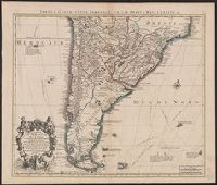
Tabula geographica Paragaiae, Chilis, Freti a Magellanici &c
Description:
Appears in Cóvens and Mortier's Atlas nouveau; cf. Koeman, C. Atlantes Neerlandici, II C & M 4., Bar scales given in "lieues marines d'Espagne" and "lieues comm. d'Espagne"., Cross Collection no. 327., Mounted in linen., Relief shown pictorially., and Shows southern part of South American continent.
Publisher:
Chez Iean Covens et Corneille Mortier ...,
Subject (Geographic):
South America--Maps--Early works to 1800
Subject (Name):
Cóvens et Mortier. Atlas nouveau
Found in:
Beinecke Rare Book and Manuscript Library > Carte du Paraguay, du Chili, du Détroit de Magellan &c [cartographic material] : dressée sur les descriptions des P.P. Alfonse d'Ovalle, et Nicolas Techo et sur les rélations et mémoires de Brouwer, Narbourough, Mr. de Beauchesne &c / par Guillaume De
Published / Created:
[1660?]
Call Number:
38291 1660
Container / Volume:
BRBL_00177
Image Count:
2
Resource Type:
Maps, Atlases & Globes
Description:
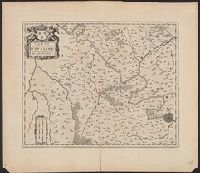
Verso: Text.
Publisher:
J. Blaeu,
Subject (Geographic):
Oise (France)--Maps--Early works to 1800
Found in:
Beinecke Rare Book and Manuscript Library > Carte du Pays Vexin Francois.
Published / Created:
[1650?]
Call Number:
3828 1650
Container / Volume:
BRBL_00177
Image Count:
2
Resource Type:
Maps, Atlases & Globes
Description:
Verso: Text.
Subject (Geographic):
Seine-et-Oise (France)--Maps--Early works to 1800
Found in:
Beinecke Rare Book and Manuscript Library > Carte du Pays et Forest D'Yueline ... De L'Hurepois.
Creator:
Published / Created:
Avril 1707.
Call Number:
401 1707
Container / Volume:
BRBL_00233
Image Count:
2
Resource Type:
Maps, Atlases & Globes
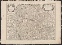
Alternative Title:
Partie meridionale du Piemont et du Monferrat
Description:
"Avec privilege"., "Desrosiers ... à Amsterdam chez Louis Renard"--Obscured print in lower left margin of southern sheet., Covers northwestern Italy., Hand colored. Stamp: Karp, Inset: Environs de Nice et de Ville-franche., and Relief shown pictorially.
Publisher:
chez l'auteur,
Subject (Geographic):
Monferrato (Italy)--Maps--Early works to 1800 and Piedmont (Italy)--Maps--Early works to 1800
Subject (Name):
Desrosiers, Liebaux, Henri, -1752, and Renard, Louis, approximately 1678-
Found in:
Beinecke Rare Book and Manuscript Library > Carte du Piemonte et du Monferrat ... / par Guillaume del'Isle ; gravé par Lièbaux le fils.
Creator:
Published / Created:
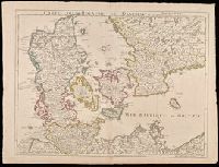
[1745]
Call Number:
BrSides Double Folio 2019 17
Image Count:
1
Resource Type:
Maps, Atlases & Globes
Description:
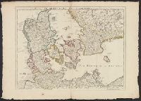
"Avec privilege du 30 Av. 1745"., Imprint in lower left: "A Paris chez l'auteur ... ", Prime meridian: Ferro., Relief shown pictorially., and Watermarks. Sheet measures 54 x 72 cm. Manuscript note on verso: 30.
Publisher:
Ph. Buache ...
Subject (Geographic):
Denmark--Maps--Early works to 1800., Schleswig-Holstein (Germany)--Maps--Early works to 1800., and Sweden--Maps--Early works to 1800.
Subject (Name):
Buache, Philippe, 1700-1773
Found in:
Beinecke Rare Book and Manuscript Library > Carte du Royaume de Danemarc / par Guill. Del'Isle, Premier Geographe du Roy de l'Academie Royale des Sciences, avec privilege Octob. 1710.
Published / Created:
1710
Call Number:
341 1710
Container / Volume:
BRBL_00091
Image Count:
1
Resource Type:
Maps, Atlases & Globes
Subject (Geographic):
Denmark--Maps--Early works to 1800
Found in:
Beinecke Rare Book and Manuscript Library > Carte du Royaume de Danemarc Par Guill. Del'Isle ... 1710.
Published / Created:
1780
Call Number:
38 1780A
Container / Volume:
BRBL_00151
Image Count:
1
Resource Type:
Maps, Atlases & Globes
Subject (Geographic):
France--Maps--Early works to 1800
Found in:
Beinecke Rare Book and Manuscript Library > Carte du Royaume de France ou sont tracées exactement les Routes de Postes Par le Sr. Robert. Groux.
Published / Created:
1838
Call Number:
48 1838
Container / Volume:
BRBL_00263
Image Count:
9
Resource Type:
Maps, Atlases & Globes
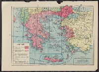
Description:
Inset: H Kphth (Crete or Candia) 1:800,000., Title and tex in Greek and Frence., and Various data in margins.
Publisher:
Ferdinand Aldenhoven ,
Subject (Geographic):
Greece--Maps
Found in:
Beinecke Rare Book and Manuscript Library > Carte du Royaume de la Grèce ... les Officiers D'État-Major de l'Armée Francaise ... Dediée à Sa Majesté le Roy de la Gréce ... Gravée et écrite par A. Forster, Lithographie Royale.
Creator:
Published / Created:
1846
Call Number:
796 1846C
Container / Volume:
BRBL_00524
Image Count:
1
Resource Type:
Maps, Atlases & Globes
Description:
Relief shown by hachures. and Shows counties.
Publisher:
lith. de Vanthielen,
Subject (Geographic):
Texas--Administrative and political divisions--Maps and Texas--Maps
Subject (Name):
Persenaire, E and Vanthielen
Found in:
Beinecke Rare Book and Manuscript Library > Carte du Texas / par M. Maris ; gravé par E. Persenaire.
Published / Created:
1782
Call Number:
755 1782A
Container / Volume:
BRBL_00433
Image Count:
1
Resource Type:
Maps, Atlases & Globes
Publisher:
Chez Esnauts et Rafilly,
Subject (Geographic):
Canada--Maps--Early works to 1800 and East (U.S.)--Maps--Early works to 1800
Found in:
Beinecke Rare Book and Manuscript Library > Carte du Théatre de la Guerre Entre les Anglais et les Américains ... Par M. Brion de las Tour Ingr. Geographe du Roi.
Branch:v1.61.8 ,Deployed:2024-06-20T11:14:48-04:00