Skip to search
Skip to main content
Skip to first result
Search
You Searched For
"Missouri"
Extent of Digitization
Completely digitized
Resource Type
Maps, Atlases & Globes
New Search
Search Results
Creator:
Published / Created:
[1860]
Call Number:
80 1860A
Container / Volume:
BRBL_00535
Image Count:
1
Resource Type:
Maps, Atlases & Globes
Description:
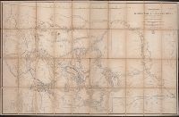
. Missouri , engineer office, official: [illegible
Publisher:
U.S. War Dept.,
Subject (Geographic):
Missouri River Watershed--Maps
Subject (Name):
Maynadier, Henry Eveleth, d. 1868
Subject (Topic):
Geology--Missouri River Watershed--Maps
Found in:
Beinecke Rare Book and Manuscript Library > Map of the Yellowstone and Missouri Rivers and their tributaries / explored by Capt. W.F. Raynolds and 1st Lieut. H.E. Maynadier, 1859-1860.
Creator:
Published / Created:
1861
Call Number:
754 1861A
Container / Volume:
BRBL_00416
Image Count:
1
Resource Type:
Maps, Atlases & Globes
Alternative Title:
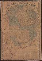
500 miles around Cairo and G. Woolworth Colton's map of the country five hundred miles around Cairo
Description:
Insets: [Map of Illinois, Missouri
Publisher:
G. Woolworth Colton,
Subject (Geographic):
Illinois--Maps and United States--History--Civil War, 1861-1865--Maps
Found in:
Beinecke Rare Book and Manuscript Library > G. Woolworth Colton's map of the country 500 miles around Cairo : showing the seat of the war in the west / Drawn, engraved & published by G. Woolworth Colton.
Published / Created:
1852?]
Call Number:
811gme 1852
Container / Volume:
BRBL_00554
Image Count:
1
Resource Type:
Maps, Atlases & Globes
Alternative Title:
Statement of the condition and prospects of the Chicago & Rock Island Railroad Company.
Description:
, Ohio, Indiana, Illinois, Missouri , Iowa
Publisher:
Chicago and Rock Island Railroad Co.?,
Subject (Name):
Chicago and Rock Island Railroad Company--Maps, Leefe, George, Michelin, Francis, and Michigan Southern and Northern Indiana Railroad Company--Maps
Found in:
Beinecke Rare Book and Manuscript Library > Map of Michigan Southern, Northern Indiana and Chicago and Rock Island railroads : with their connections from Council Bluffs to New York / lith. by F. Michelin & Geo. Leefe.
Creator:
Published / Created:
c1974.
Call Number:
8101 1974
Container / Volume:
BRBL_00552
Image Count:
2
Resource Type:
Maps, Atlases & Globes
Alternative Title:
North Central States.
Description:
, Iowa, Missouri .
Subject (Geographic):
Middle West--Maps
Subject (Name):
Cook, David W., 1931- and Peele, William T
Found in:
Beinecke Rare Book and Manuscript Library > Close-up: U.S.A., the North Central States. Produced by the Cartographic Division, National Geographic Society. William T. Peele, chief cartographer; David W. Cook, associate chief cartographer.
Creator:
Published / Created:
[1855 or 1856?]
Call Number:
814 1855H
Container / Volume:
BRBL_00557
Image Count:
1
Resource Type:
Maps, Atlases & Globes
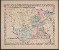
Description:
to White Earth and Missouri rivers to the
Publisher:
J. H. Colton & Co.,
Subject (Geographic):
Minnesota--Maps, North Dakota--Maps, and South Dakota--Maps
Found in:
Beinecke Rare Book and Manuscript Library > Minnesota.
Creator:
Published / Created:
[1855 or 1856?]
Call Number:
814 1855F
Container / Volume:
BRBL_00557
Image Count:
1
Resource Type:
Maps, Atlases & Globes
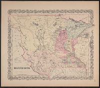
Description:
Chippewa areas, with Missouri River and White
Publisher:
J.H. Colton & Co.,
Subject (Geographic):
Minnesota--Maps, North Dakota--Maps, and South Dakota--Maps
Found in:
Beinecke Rare Book and Manuscript Library > Minnesota.
Creator:
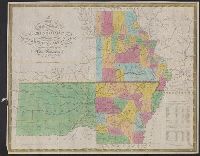
Published / Created:
1833
Call Number:
80 1833
Container / Volume:
BRBL_00532
Image Count:
1
Resource Type:
Maps, Atlases & Globes
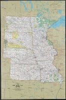
Description:
Includes population table., Prime meridian: Washington., Relief shown by hachures., and Shows counties and location of Indian tribes.
Publisher:
S. Augustus Mitchell,
Subject (Geographic):
Missouri --Maps
Subject (Name):
Young, J. H. (James Hamilton)
Found in:
Beinecke Rare Book and Manuscript Library > Map of the state of Missouri and territory of Arkansas / compiled from the latest authorities ; J.H. Young, sc.
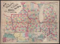
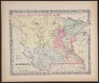
Creator:
Published / Created:
1858
Call Number:
754gme 1858
Container / Volume:
BRBL_00420
Image Count:
1
Resource Type:
Maps, Atlases & Globes
Description:
"Entered according to Act of Congress in the year 1858, by J.H. Colton & Co., in the Clerk's Office of the District Court for Southern District of New York.", Illustration within title: "Bridge across the west channel of the Mississippi at Davenport.", and Inse
Publisher:
J.H. Colton & Co.,
Subject (Geographic):
Middle West--Maps. and United States--Maps
Subject (Name):
Streeter, Thomas W.--(Thomas Winthrop),--1883-1965--Stamp.
Subject (Topic):
Railroads--Middle West--Maps and Railroads--United States--Maps
Found in:
Beinecke Rare Book and Manuscript Library > Map of the Mississippi and Missouri Railroad : and its connections.
Creator:
Published / Created:
July. 1st 1833.
Call Number:
806 1833
Container / Volume:
BRBL_00547
Image Count:
1
Resource Type:
Maps, Atlases & Globes
Description:
Below neat line at left: Tanner., Engraved by: J. & C. Walker., From: Society for the Diffusion ... General atlas., and Sheet measures 35.5 x 32 cm.
Publisher:
Baldwin & Cradock,
Subject (Geographic):
Illinois--Maps and Middle West--Maps
Subject (Name):
Baldwin & Cradock, J. and C. Walker, and Tanner, Henry Schenck, 1786-1858
Found in:
Beinecke Rare Book and Manuscript Library > North America sheet IX : Parts of Missouri, Illinois and Indiana.
Creator:
Published / Created:
[1855 or 1856?]
Call Number:
814 1855E
Container / Volume:
BRBL_00557
Image Count:
2
Resource Type:
Maps, Atlases & Globes
Alternative Title:
Territory of Minnesota.
Description:
Chippewa areas, with Missouri River and White
Publisher:
J.H. Colton & Co.,
Subject (Geographic):
Minnesota--Maps, North Dakota--Maps, and South Dakota--Maps
Found in:
Beinecke Rare Book and Manuscript Library > Minnesota.
Branch:v1.61.6 ,Deployed:2024-06-12T09:55:31-04:00