Skip to search
Skip to main content
Skip to first result
Search
You Searched For
Date
1850 - 1899
"Massachusetts"
Extent of Digitization
Completely digitized
Resource Type
Maps, Atlases & Globes
Date Created
1850 to 1899
New Search
Search Results
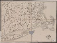
Creator:
Massachusetts . Board of Railroad Commissioners
Published / Created:
1882
Call Number:
764gme 1882
Container / Volume:
BRBL_00462
Image Count:
1
Resource Type:
Maps, Atlases & Globes
Description:
Shows railroads in Massachusetts and
Publisher:
Rand, Avery & Co. Engravers and Printers,
Subject (Geographic):
Massachusetts --Maps
Subject (Topic):
Railroads--Massachusetts --Maps
Found in:
Beinecke Rare Book and Manuscript Library > Map of the railroads of the state of Massachusetts : accompanying the report of the Railroad Commissioners.
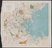
Creator:
Massachusetts . Metropolitan Park Commission
Published / Created:
1893
Call Number:
764 B65 1893
Container / Volume:
BRBL_00456
Image Count:
1
Resource Type:
Maps, Atlases & Globes
Description:
"Contour interval 20 feet.", "Dated January 2d 1893.", and From: House No. 150, Report of the Board of Metropolitan Park Commissioners, January, 1893.
Publisher:
Metropolitan Park Commission],
Subject (Name):
Eliot, Charles, 1859-1897
Subject (Topic):
Open spaces--Massachusetts --Boston
Found in:
Beinecke Rare Book and Manuscript Library > Map of the metropolitan district of Boston, Massachusetts : showing the existing public reservations and such new open spaces as are proposed by Charles Eliot, Landscape Architect, in his report to the Metropolitan Park Commission.
Published / Created:
1884
Call Number:
764gme 1884
Container / Volume:
BRBL_00462
Image Count:
1
Resource Type:
Maps, Atlases & Globes
Description:
Shows railroads in Massachusetts and
Publisher:
Wright & Potter Printing Co.,
Subject (Geographic):
Massachusetts --Maps
Found in:
Beinecke Rare Book and Manuscript Library > Map of the railroads of the state of Massachusetts : accompanying the report of the Railroad Commissioners.
Published / Created:
c1891
Call Number:
764 P74 1891
Container / Volume:
BRBL_00459
Image Count:
1
Resource Type:
Maps, Atlases & Globes
Description:
Massachusetts . [Unknown ed.] p. 102-103.
Publisher:
Geo. H. Walker & Co.,
Subject (Geographic):
Massachusetts --Maps
Subject (Name):
Geo. H. Walker and Co
Found in:
Beinecke Rare Book and Manuscript Library > Massachusetts atlas plate no. 6 [Southern Norfolk and Plymouth counties].
Creator:
Published / Created:
c1896.
Call Number:
764 1896
Container / Volume:
BRBL_00453
Image Count:
1
Resource Type:
Maps, Atlases & Globes
Description:
Massachusetts , p. 26-27.
Publisher:
Geo. H. Walker & Co.,
Found in:
Beinecke Rare Book and Manuscript Library > Massachusetts atlas plate no. 2 [part of Essex County including Cape Ann].
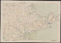
Creator:
Massachusetts . Board of Railroad Commissioners
Published / Created:
1874
Call Number:
764gme 1874
Container / Volume:
BRBL_00462
Image Count:
1
Resource Type:
Maps, Atlases & Globes
Description:
"Scale, Six Miles to the Inch.", Imperfect. Mutilated with loss of text., and Names counties and shows their boundaries. Shows only those populated places which are on rail lines. Covers southern Vermont and New Hampshire, Connecticut, Rhode Island, Long Island
Publisher:
The Board,
Subject (Geographic):
Massachusetts --Maps
Subject (Topic):
Railroads--Massachusetts --Maps
Found in:
Beinecke Rare Book and Manuscript Library > Map of the railroads of the state of Massachusetts : accompanying the report of the railroad commissioners. 1874.
Creator:
Published / Created:
c1893.
Call Number:
764gmb 1893
Container / Volume:
BRBL_00462
Image Count:
10
Resource Type:
Maps, Atlases & Globes
Description:
3rd ed., Insets: Marthas Vineyard (Dukes Co.) -- Nantucket (Nantucket Co.)., Relief shown by hachures., and Sheet 9 imperfect: mutilated with possible loss of text.
Publisher:
Arthur W. Robinson,
Subject (Geographic):
Massachusetts --Maps
Subject (Name):
. Massachusetts Division
Subject (Topic):
Bicycle trails--Massachusetts --Maps
Found in:
Beinecke Rare Book and Manuscript Library > Cyclists' road map of Massachusetts / prepared expressly for the Mass. Div. L.A.W., by William T. Oliver.
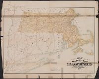
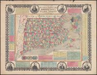
Creator:
Published / Created:
1855
Call Number:
76 1855
Container / Volume:
BRBL_00445
Image Count:
1
Resource Type:
Maps, Atlases & Globes
Alternative Title:
Massachusetts , Connecticut and Rhode
Description:
"Entered according to act of Congress in the year 1855 by Ensign, Bridgman & Fanning ..." and Border includes 8 portraits (John Hancock, Cotton Mather, Daniel Webster, Roger Williams, Gov. Trumbull, Timothy Dwight, O. Ellsworth, and Gen. Greene), 3 vignettes,
Publisher:
Ensign, Bridgman & Fanning,
Subject (Geographic):
Massachusetts --Maps
Subject (Topic):
Cities and towns--Massachusetts --Maps
Found in:
Beinecke Rare Book and Manuscript Library > Township map of Massachusetts, Connecticut and Rhode Island.
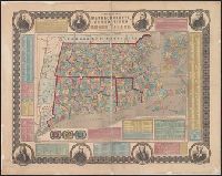
Creator:
Published / Created:
1855
Call Number:
76 1855
Container / Volume:
BRBL_00445
Image Count:
1
Resource Type:
Maps, Atlases & Globes
Alternative Title:
Massachusetts , Connecticut and Rhode
Description:
"Entered according to act of Congress in the year 1855 by Ensign, Bridgman & Fanning ...", Border includes 8 portraits (J, Hand colored by township. State and county borders outlined., Inset: "Boston.", and Prime meridian: Washington (top) and Greenwich (bottom).
Publisher:
Ensign, Bridgman & Fanning,
Subject (Geographic):
Massachusetts --Maps
Subject (Topic):
Cities and towns--Massachusetts --Maps
Found in:
Beinecke Rare Book and Manuscript Library > Township map of Massachusetts, Connecticut and Rhode Island.
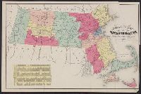
Creator:
Published / Created:
1874
Call Number:
764 1874R
Container / Volume:
BRBL_00453
Image Count:
1
Resource Type:
Maps, Atlases & Globes
Description:
Counties differentiated by var. colors., Includes table of population and distance data from Census of 1870., and Relief shown by hachures.
Publisher:
B.B. Russell,
Found in:
Beinecke Rare Book and Manuscript Library > Russell's map of Massachusetts.
Branch:v1.61.6 ,Deployed:2024-06-12T09:55:36-04:00