Search
You Searched For
Search Results
- Published / Created:
- 19--?]
- Call Number:
- 778 1781
- Container / Volume:
- BRBL_00504A
- Image Count:
- 1
- Resource Type:
- Maps, Atlases & Globes
- Description:
- Reproduction of London, J. Bew, 1781, map issued by Colonial Williamsburg.
- Publisher:
- s.n.,
- Subject (Geographic):
- Chesapeake Bay (Md. and Va.)--Maps--Early works to 1800
- Found in:
- Beinecke Rare Book and Manuscript Library > A Map and Chart of these parts of the Bay of Chesapeak. York and James Rivers wich are at present the seat of war.
- Call Number:
- 777 C425 1799
- Container / Volume:
- BRBL_00503
- Image Count:
- 1
- Resource Type:
- Maps, Atlases & Globes
- Description:
- Allardice sc.
- Subject (Geographic):
- Chesapeake Bay (Md. and Va.)--Maps--Early works to 1800
- Found in:
- Beinecke Rare Book and Manuscript Library > A map of the head of the Chesapeake Bay and Susquehanna River shewing the navigation of the same with a topographical description of the surrounding country from an actual survey by C.P. Hauducoeur 1799.
- Creator:
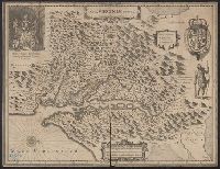
- Hondius, Hendrik, 1597-1651
- Published / Created:
- [1649]
- Call Number:
- 783 1642
- Container / Volume:
- BRBL_00507
- Image Count:
- 2
- Resource Type:
- Maps, Atlases & Globes
- Alternative Title:
- Nova Virginiae tabvla
- Description:
- French text on verso, with running and caption title "Virginie," signature e, and catchword "ses."
- Publisher:
- Ex officina Henrici Hondii,
- Subject (Geographic):
- Chesapeake Bay (Md. and Va.)--Maps--Early works to 1800, Maryland--Maps--Early works to 1800, and Virginia--Maps--Early works to 1800
- Subject (Name):
- Jansson, Jan, 1588-1664. Atlas novus. French and Smith, John, 1580-1631
- Found in:
- Beinecke Rare Book and Manuscript Library > Nova Virginiae tabula [cartographic material].
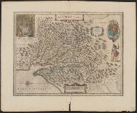
- Creator:
- Hondius, Hendrik, 1597-1651
- Published / Created:
- [1652]
- Call Number:
- 783 1652
- Container / Volume:
- BRBL_00507
- Image Count:
- 2
- Resource Type:
- Maps, Atlases & Globes
- Alternative Title:
- Nova Virginiae tabvla
- Description:
- Dutch text on verso, with running and caption title "Virginia," signature 2D, and catchword "riviere."
- Publisher:
- Ex officina Henrici Hondii,
- Subject (Geographic):
- Chesapeake Bay (Md. and Va.)--Maps--Early works to 1800, Maryland--Maps--Early works to 1800, and Virginia--Maps--Early works to 1800
- Subject (Name):
- Jansson, Jan, 1588-1664. Atlas novus. Dutch and Smith, John, 1580-1631
- Found in:
- Beinecke Rare Book and Manuscript Library > Nova Virginiae tabula [cartographic material].
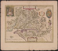
- Creator:
- Hondius, Hendrik, 1597-1651
- Published / Created:
- [1638]
- Call Number:
- 783 1638
- Container / Volume:
- BRBL_00691
- Image Count:
- 2
- Resource Type:
- Maps, Atlases & Globes
- Alternative Title:
- Nova Virginiae tabvla
- Description:
- Hand col. Sheet measures 50.8 x 58.2 cm. Cross Collection no. 213.
- Publisher:
- Ex officina Henrici Hondii,
- Subject (Geographic):
- Chesapeake Bay (Md. and Va.)--Maps--Early works to 1800, Maryland--Maps--Early works to 1800, and Virginia--Maps--Early works to 1800
- Subject (Name):
- Hondius, Hendrik, 1597-1651. Atlas novus, Jansson, Jan, 1588-1664. Atlas novus, and Smith, John, 1580-1631
- Found in:
- Beinecke Rare Book and Manuscript Library > Nova Virginiae tabula [cartographic material].
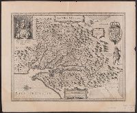
- Creator:
- Hondius, Hendrik, 1597-1651
- Published / Created:
- [1633]
- Call Number:
- 783 1633
- Container / Volume:
- BRBL_00730
- Image Count:
- 2
- Resource Type:
- Maps, Atlases & Globes
- Alternative Title:
- Nova Virginiae tabvla
- Description:
- Hendrik Hondius' derivative of John Smith's map of Virginia, 1612.
- Publisher:
- Ex officina Henrici Hondii,
- Subject (Geographic):
- Chesapeake Bay (Md. and Va.)--Maps--Early works to 1800, Maryland--Maps--Early works to 1800, and Virginia--Maps--Early works to 1800
- Subject (Name):
- Jansson, Jan, 1588-1664. Atlas novus. French and Smith, John, 1580-1631
- Found in:
- Beinecke Rare Book and Manuscript Library > Nova Virginiae tabula [cartographic material].