Search
You Searched For
Search Results
- Published / Created:
- 1806
- Call Number:
- 755 1806B
- Container / Volume:
- BRBL_00438
- Image Count:
- 1
- Resource Type:
- Maps, Atlases & Globes
- Publisher:
- J. Cary,
- Subject (Geographic):
- Canada--Maps and East (U.S.)--Maps
- Found in:
- Beinecke Rare Book and Manuscript Library > A new map of the United States of America ... by John Cary, Engraver.
- Published / Created:
- 1805
- Call Number:
- 755 1805B
- Container / Volume:
- BRBL_00437
- Image Count:
- 1
- Resource Type:
- Maps, Atlases & Globes
- Description:
- Plain and colored.
- Publisher:
- J. Cary,
- Subject (Geographic):
- Canada--Maps and East (U.S.)--Maps
- Found in:
- Beinecke Rare Book and Manuscript Library > A new map of the United States of North America ... with Upper and Lower Canada &c ... by John Cary, Engraver.
- Published / Created:
- 1813
- Call Number:
- 755 1813
- Container / Volume:
- BRBL_00438
- Image Count:
- 1
- Resource Type:
- Maps, Atlases & Globes
- Description:
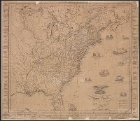
- Post road distances and population of states and territories in margins. Vignettes of naval actions in Atlantic. and Preliminary record.
- Subject (Geographic):
- Canada--Maps and East (U.S.)--Maps
- Found in:
- Beinecke Rare Book and Manuscript Library > An improved Map of the United States by Shelton & Kensett. Engraved by A. Doolittle, New Haven, & T. Kensett, Cheshire. Copyright secured & entered according to Act of Congress, July 6th 1813.
- Published / Created:
- 1813
- Call Number:
- 755 1813C
- Container / Volume:
- BRBL_00439
- Image Count:
- 1
- Resource Type:
- Maps, Atlases & Globes
- Description:
- Post road distances and population of states and territories in margins. Vignettes of naval actions in Atlantic.
- Publisher:
- Shelton & Kensett,
- Subject (Geographic):
- Canada--Maps and East (U.S.)--Maps
- Found in:
- Beinecke Rare Book and Manuscript Library > An improved Map of the United States by Shelton & Kensett. Engraved by A. Doolittle, New Haven. AE 60. Copyright secured & entered according to Act of Congress, Nov. 8th 1813.
- Published / Created:
- July 6th 1813.
- Call Number:
- 755 1813B
- Container / Volume:
- BRBL_00438
- Image Count:
- 1
- Resource Type:
- Maps, Atlases & Globes
- Description:
- A later issue of 755 1813, & 755 1813A.
- Subject (Geographic):
- Canada--Maps and East (U.S.)--Maps
- Found in:
- Beinecke Rare Book and Manuscript Library > An improved map of the United States by Shelton & Kensett. Engraved by A. Doolittle, New Haven, & T. Kensett, Cheshire ...
- Published / Created:
- July 6th 1813.
- Call Number:
- 755 1813A
- Container / Volume:
- BRBL_00438
- Image Count:
- 1
- Resource Type:
- Maps, Atlases & Globes
- Description:
- A later issue of 755 1813.
- Subject (Geographic):
- Canada--Maps and East (U.S.)--Maps
- Found in:
- Beinecke Rare Book and Manuscript Library > An improved map of the United States by Shelton & Kensett. Engraved by A. Doolittle, New Haven, & T. Kensett, Cheshire ...
- Published / Created:
- 1828
- Call Number:
- 755cea 1828
- Container / Volume:
- BRBL_00442
- Image Count:
- 1
- Resource Type:
- Maps, Atlases & Globes
- Publisher:
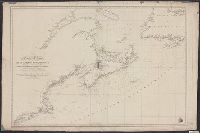
- Direccion Hidrográfica,
- Subject (Geographic):
- Canada--Maps and East (U.S.)--Maps
- Found in:
- Beinecke Rare Book and Manuscript Library > Carta Esferica de las Costas Orientales de la America Setentrional que comprende desde Nueva York hasta el Golfo y Rio Sn. Lorenzo con parte de la Isla de Terranova.
- Published / Created:
- [1805?]
- Call Number:
- 755 1805A
- Container / Volume:
- BRBL_00437
- Image Count:
- 1
- Resource Type:
- Maps, Atlases & Globes
- Subject (Geographic):
- Canada--Maps and East (U.S.)--Maps
- Found in:
- Beinecke Rare Book and Manuscript Library > Carta delle Provinciae Settentrionli degli Stati Uniti.
- Published / Created:
- [1806?]
- Call Number:
- 755 1806C
- Container / Volume:
- BRBL_00438
- Image Count:
- 1
- Resource Type:
- Maps, Atlases & Globes
- Publisher:
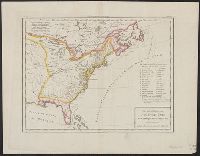
- Tardieu,
- Subject (Geographic):
- Canada--Maps and East (U.S.)--Maps
- Found in:
- Beinecke Rare Book and Manuscript Library > Carte Générale des États-Unis de L'Amerique Septentrionale, rensemant aussi, quelquis Provinces Angloises adjacentes. André Scrip. Tardieu Sculp.