Search
You Searched For
Search Results
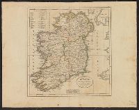
- Published / Created:
- [1795?]
- Call Number:
- 327 1795A
- Container / Volume:
- BRBL_00072
- Image Count:
- 1
- Resource Type:
- Maps, Atlases & Globes
- Found in:
- Beinecke Rare Book and Manuscript Library > A Map of Ireland ...
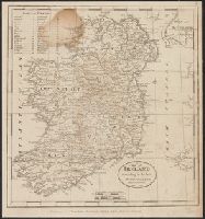
- Published / Created:
- 1795
- Call Number:
- 327 1795B
- Container / Volume:
- BRBL_00072
- Image Count:
- 1
- Resource Type:
- Maps, Atlases & Globes
- Found in:
- Beinecke Rare Book and Manuscript Library > A Map of Ireland according to the best authorities.
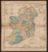
- Published / Created:
- [1798?]
- Call Number:
- 327 1798
- Container / Volume:
- BRBL_00073
- Image Count:
- 1
- Resource Type:
- Maps, Atlases & Globes
- Found in:
- Beinecke Rare Book and Manuscript Library > A Map of Ireland according to the best authorities. Engraved for Plowden's Historical Review of the State of Ireland.
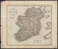
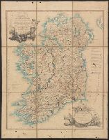
- Published / Created:
- [1795?]
- Call Number:
- 327 1795
- Container / Volume:
- BRBL_00072
- Image Count:
- 1
- Resource Type:
- Maps, Atlases & Globes
- Found in:
- Beinecke Rare Book and Manuscript Library > A map of Ireland ... J.T. Scott. Sculp.
- Published / Created:
- 1759
- Call Number:
- 327cea C81 1759
- Container / Volume:
- BRBL_00074
- Image Count:
- 1
- Resource Type:
- Maps, Atlases & Globes
- Found in:
- Beinecke Rare Book and Manuscript Library > A new and correct chart of the Harbour of Corke by the Revd. J. Lindsay. J. Mynde Sculp.
- Published / Created:
- 1714
- Call Number:
- 327 1714
- Container / Volume:
- BRBL_00072
- Image Count:
- 1
- Resource Type:
- Maps, Atlases & Globes
- Found in:
- Beinecke Rare Book and Manuscript Library > A new map of Ireland ... Herman Moll, Geographer 1714.
- Published / Created:
- 1799
- Call Number:
- 327 1799
- Container / Volume:
- BRBL_00073
- Image Count:
- 1
- Resource Type:
- Maps, Atlases & Globes
- Found in:
- Beinecke Rare Book and Manuscript Library > A new map of Ireland ... by John Cary, Engraver.
- Published / Created:
- 1793
- Call Number:
- 327 1793
- Container / Volume:
- BRBL_00072
- Image Count:
- 1
- Resource Type:
- Maps, Atlases & Globes
- Found in:
- Beinecke Rare Book and Manuscript Library > A new map of Ireland ... distances between the Towns & Stages, marked in miles and furlongs ... by Alexander Taylor ... Royal Engineers.
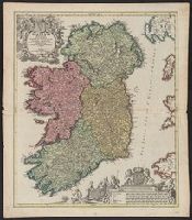
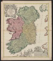
- Creator:
- Homann, Johann Baptist, 1663-1724
Visscher, Nicolaes, 1649-1702
- Published / Created:
- 1715?]
- Call Number:
- 327 1696
- Container / Volume:
- BRBL_00072
- Image Count:
- 1
- Resource Type:
- Maps, Atlases & Globes
- Found in:
- Beinecke Rare Book and Manuscript Library > Hiberniae regnum tam in praecipuas Ultoniae, Connaciae, Laceniae et Momoniae [cartographic material] : quam in minores earundem provincias et ditiones divisum ex prototype Guil. Petty-Vischeriano deductu et exhibitum / a Joh. Bapt. Homanno.