Search
You Searched For
Search Results
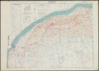
- Creator:
- Great Britain. Army. Royal Engineers. Field Survey Coy., 512th
- Published / Created:
- 1942
- Call Number:
- 691 B43 1942
- Container / Volume:
- BRBL_00352
- Image Count:
- 1
- Resource Type:
- Maps, Atlases & Globes
- Alternative Title:
- 1:250,000 EGYPT AND CYRENAICA ; Sheet 1 Bengasi, 1:250,000 EGYPT AND CYRENAICA ; Sheet 1 Bengasi., and Sheet 1
- Description:
- "M.D.R. 1006/1646".
- Publisher:
- 512 (Fd. Svy.) Coy, R.E.,
- Subject (Geographic):
- Libya--Maps
- Found in:
- Beinecke Rare Book and Manuscript Library > Bengasi, Sheet 1 / compiled, drawn, and reproduced by 512 Fd. Survey Coy., R.E., Nov., 1942.
- Published / Created:
- 1922
- Call Number:
- 69 1922A
- Container / Volume:
- BRBL_00352
- Image Count:
- 1
- Resource Type:
- Maps, Atlases & Globes
- Description:
- "C. Salussolia, autogr."
- Publisher:
- Ministero delle Colonie,
- Subject (Geographic):
- Libya--Maps
- Found in:
- Beinecke Rare Book and Manuscript Library > Cirenaica (e regioni adiacenti).
- Creator:
- Germany. Heer. Heeresplankammer
- Published / Created:
- 1942
- Call Number:
- 69cbf 1942
- Container / Volume:
- BRBL_00352
- Image Count:
- 1
- Resource Type:
- Maps, Atlases & Globes
- Description:
- Military grid.
- Publisher:
- Heeresplankammer,
- Subject (Geographic):
- Libya--Maps
- Subject (Name):
- Germany. Heer. Abteilung für Kriegskarten- und Vermessungswesen
- Found in:
- Beinecke Rare Book and Manuscript Library > Libyen / im auftrage Gen St d H Abt f Kr Kart u Verm Wes (II); bearbeitet und herausgegeben von der Heeresplankammer.
- Creator:
- Petermann, A. (August Heinrich), 1822-1878
- Published / Created:
- 1855
- Call Number:
- 69 1855
- Container / Volume:
- BRBL_00352
- Image Count:
- 1
- Resource Type:
- Maps, Atlases & Globes
- Alternative Title:
- Northern Africa and Petermanns geographische Mittheilungen.
- Description:
- "London, March 1854, published for the author by E. Stanford, 6 Charing Cross."
- Publisher:
- Justus Perthes,
- Subject (Geographic):
- Libya--Discovery and exploration--Maps and Libya--Maps
- Subject (Name):
- Barth, Heinrich,--1821-1865, Overweg, Adolph,--1813-1852, Richardson, James,--1806-1851, Stanford, Edward, 1827-1904, and Vogel, Edward,--1829-1856
- Found in:
- Beinecke Rare Book and Manuscript Library > Map of part of northern Africa, showing the routes of the expedition under Messrs. Richardson, Barth, Overweg & Vogel in the years 1850 and 1853 / constructed by Augustus Petermann.
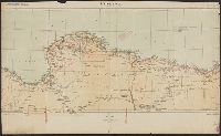
- Published / Created:
- 1922
- Call Number:
- 69 1922
- Container / Volume:
- BRBL_00352
- Image Count:
- 1
- Resource Type:
- Maps, Atlases & Globes
- Description:
- "C. Salussolia, autogr."
- Publisher:
- Ministero delle Colonie,
- Subject (Geographic):
- Libya--Maps
- Found in:
- Beinecke Rare Book and Manuscript Library > Tripolitania Settentrionale.
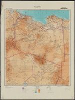
- Published / Created:
- [1942?]
- Call Number:
- 69 1942
- Container / Volume:
- BRBL_00352
- Image Count:
- 1
- Resource Type:
- Maps, Atlases & Globes
- Description:
- Includes six insets.
- Publisher:
- Die Abteilung,
- Subject (Geographic):
- Libya--Maps
- Subject (Name):
- Germany. Heer. Abteilung für Kriegskarten- und Vermessungswesen
- Found in:
- Beinecke Rare Book and Manuscript Library > Verkehrskarte von Nord-Libyen / im Auftrage Gen. St. d. H., Abt. f. Kr. Kart. u. Verm. Wes. (II), herausgegeben von der Heeresplankammer.