Search
You Searched For
Search Results
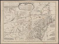
- Creator:
- Evans, Lewis, 1700?-1756
- Published / Created:
- 1771
- Call Number:
- 755 1771C
- Container / Volume:
- BRBL_00429
- Image Count:
- 1
- Resource Type:
- Maps, Atlases & Globes
- Found in:
- Beinecke Rare Book and Manuscript Library > A general map of the middle British colonies in America : viz. Virginia, Maryland, Delaware, Pensilvania, New-Jersey, New York, Connecticut & Rhode-Island : of Aquanishuonigy the country of the confederate Indians comprehending Aquanishuonigy proper, thei
- Creator:
- Gibson, J. (John)
- Published / Created:
- 1758
- Call Number:
- 755 1758
- Container / Volume:
- BRBL_00428
- Image Count:
- 1
- Resource Type:
- Maps, Atlases & Globes
- Found in:
- Beinecke Rare Book and Manuscript Library > A general map of the middle British colonies in America : viz. Virginia, Maryland, Delaware, Pensilvania, New-Jersey, New-York, Connecticut and Rhode-Island : of Aquanishuonigy the country of the confederate Indians comprehending Aquanishuonigy proper, th
- Creator:
- Jefferys, Thomas, d. 1771
- Published / Created:
- 1775 June 15
- Call Number:
- 755 1775D
- Container / Volume:
- BRBL_00429
- Image Count:
- 1
- Resource Type:
- Maps, Atlases & Globes
- Found in:
- Beinecke Rare Book and Manuscript Library > A general map of the middle British colonies in America : viz. Virginia, Maryland, Delaware, Pensilvania, New-Jersey, New-York, Connecticut, and Rhode-Island : of Aquanishuonîgy the country of the Confederate Indians comprehending Aquanishuonigy proper,
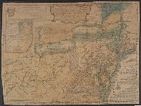
- Creator:
- Evans, Lewis, 1700?-1756
- Published / Created:
- 1771
- Call Number:
- 755 1771B
- Container / Volume:
- BRBL_00429
- Image Count:
- 1
- Resource Type:
- Maps, Atlases & Globes
- Found in:
- Beinecke Rare Book and Manuscript Library > A general map of the middle British colonies in America, viz. Virginia, Maryland, Delaware, Pensilvania, New-Jersey, New York, Connecticut & Rhode Island: Of Aquanishuonigy the country of the confederate Indians comprehending Aquanishuonigy proper, their
- Creator:
- Robert Sayer and John Bennett (Firm)
- Published / Created:
- 1776
- Call Number:
- 755 1776
- Container / Volume:
- BRBL_00430
- Image Count:
- 1
- Resource Type:
- Maps, Atlases & Globes
- Found in:
- Beinecke Rare Book and Manuscript Library > A general map of the middle British colonies, in America [cartographic material] : Containing Virginia, Maryland, the Delaware counties, Pennsylvania and New Jersey. With the addition of New York, and the greatest part of New England, as also of the borde
- Creator:
- Evans, Lewis, 1700?-1756
- Published / Created:
- 1755
- Call Number:
- 755 1755
- Container / Volume:
- BRBL_00427
- Image Count:
- 1
- Resource Type:
- Maps, Atlases & Globes
- Found in:
- Beinecke Rare Book and Manuscript Library > A general map of the middle British colonies, in America; viz. Virginia, Mariland, Delaware, Pensilvania, New-Jersey, New-York, Connecticut, and Rhode Island: Of Aquanishuonîgy, the country of the Confederate Indians; comprehending Aquanishuonîgy proper
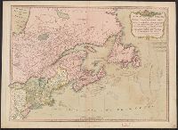
- Published / Created:
- 1794 May 12
- Call Number:
- 755 1794G
- Container / Volume:
- BRBL_00436
- Image Count:
- 1
- Resource Type:
- Maps, Atlases & Globes
- Found in:
- Beinecke Rare Book and Manuscript Library > A new and correct map of the British colonies in North America comprehending eastern Canada with the province of Quebec, New Brunswick, Nova Scotia, and the Government of Newfoundland [cartographic material] : with the adjacent states of New England, Verm
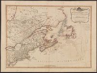
- Published / Created:
- 1794 May 12
- Call Number:
- 755 1794E
- Container / Volume:
- BRBL_00436
- Image Count:
- 1
- Resource Type:
- Maps, Atlases & Globes
- Found in:
- Beinecke Rare Book and Manuscript Library > A new and correct map of the British colonies in North America comprehending eastern Canada with the province of Quebec, New Brunswick, Nova Scotia, and the Government of Newfoundland [cartographic material] : with the adjacent states of New England, Verm
- Published / Created:
- 1794 May 12
- Call Number:
- 71 1794A
- Container / Volume:
- BRBL_00687
- Image Count:
- 1
- Resource Type:
- Maps, Atlases & Globes
- Found in:
- Beinecke Rare Book and Manuscript Library > A new and correct map of the British colonies in North America comprehending eastern Canada with the province of Quebec, New Brunswick, Nova Scotia, and the Government of Newfoundland [cartographic material] : with the adjacent states of New England, Verm
- Published / Created:
- 12th May, 1794.
- Call Number:
- 71 1794L
- Container / Volume:
- BRBL_00726
- Image Count:
- 1
- Resource Type:
- Maps, Atlases & Globes
- Found in:
- Beinecke Rare Book and Manuscript Library > A new and correct map of the British colonies in North America comprehending eastern Canada with the province of Quebec, New Brunswick, Nova Scotia, and the Government of Newfoundland [cartographic material] : with the adjacent states of New England, Verm