Skip to search
Skip to main content
Skip to first result
Search
You Searched For
Extent of Digitization
Completely digitized
Subject (Geographic)
Philadelphia (Pa.)--Maps
Search Results
Published / Created:
[1926?]
Call Number:
774 P53 1926
Container / Volume:
BRBL_00730
Image Count:
1
Resource Type:
Maps, Atlases & Globes
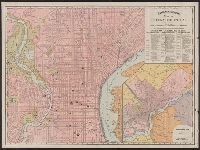
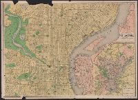
Description:
Pictorial border consisting of 5 inset maps: Melish's map, 1816, Penn's lots, 1698, Penn's plan, 1682, New Sweden, 1654, and the Sesqvi Centennial international exposition; the seals of Penn's colony and of the city of Philadelphia, 1701 and 1784; and...
Publisher:
Houghton Mifflin Co.,
Subject (Geographic):
Philadelphia (Pa.)--Maps
Found in:
Beinecke Rare Book and Manuscript Library > A kite view of Philadelphia and the Sesquicentennial international exposition ... / designed, drawn and colored by Edwin Olsen and Blake Clark.
Creator:
Published / Created:
c1891.
Call Number:
774 P53 1891
Collection Title:
Rand McNally and Co.'s Indexed atlas of the world.
Container / Volume:
BRBL_00500
Image Count:
1
Resource Type:
Maps, Atlases & Globes
Alternative Title:
Philadelphia and vicinity. and Rand McNally & Co.'s new business atlas map of Philadelphia.
Description:
"90, 91."
Publisher:
Rand McNally,
Subject (Geographic):
Philadelphia (Pa.)--Maps and Philadelphia Metropolitan Area (Pa.)--Maps
Subject (Name):
Rand McNally and Company. Rand McNally & Co.'s indexed atlas of the world
Subject (Topic):
Harbors--Pennsylvania--Philadelphia Metropolitan Area--Maps
Found in:
Beinecke Rare Book and Manuscript Library > Map of Philadelphia / Rand McNally & Co., Engravers.
Published / Created:
1877
Call Number:
774 P53 1877
Container / Volume:
BRBL_00500
Image Count:
1
Resource Type:
Maps, Atlases & Globes
Description:
Printed on cloth measuring 70 x 61 cm.
Subject (Geographic):
Philadelphia (Pa.)--Maps
Found in:
Beinecke Rare Book and Manuscript Library > Map of Philadelphia.
Creator:
Published / Created:
1909
Call Number:
774gmb 1909
Container / Volume:
BRBL_00501A
Image Count:
1
Resource Type:
Maps, Atlases & Globes
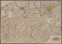
Alternative Title:
Mendenhall's new road map of Erie County, Mendenhall's new road map of Philadelphia district, Mendenhall's new road maps of Harrisburg district, Mendenhall's road map Pittsburg district, Mendenhall's road map Reading district, and Mendenhall's road map Scranton and Wilkes Barre district
Description:
Automobile roads identified by number keyed to text.
Publisher:
C.S. Mendenhall,
Subject (Geographic):
Erie County (Pa.)--Maps, Harrisburg (Pa.)--Maps, Pennsylvania--Maps, Philadelphia (Pa.)--Maps, Pittsburgh (Pa.)--Maps, Reading (Pa.)--Maps, Scranton (Pa.)--Maps, and Wilkes-Barre (Pa
Found in:
Beinecke Rare Book and Manuscript Library > Mendenhall's guide & road map of Pennsylvania, showing main touring routes & good roads, locations of towns, post offices, r.r. &c.
Creator:
Published / Created:
c1876.
Call Number:
774 P53 1876A
Container / Volume:
BRBL_00500
Image Count:
1
Resource Type:
Maps, Atlases & Globes
Description:
Describes location of steam railroad passenger depots.
Publisher:
O.W. Gray & Son,
Subject (Geographic):
Philadelphia (Pa.)--Maps
Found in:
Beinecke Rare Book and Manuscript Library > Philadelphia / [cartographic material] / O.W. Gray & Son.
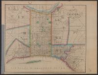
Published / Created:
1833
Call Number:
774 P53 1833
Container / Volume:
BRBL_00499
Image Count:
1
Resource Type:
Maps, Atlases & Globes
Description:
Engarving colored hand to show districts, squares. Built up sections stippled, projected streets, dotted; ward numbers, proposed routes of the Columbia & Philadelphia R.R.
Publisher:
E.L. Carey & A. Hart,
Subject (Geographic):
Philadelphia (Pa.)--Maps
Found in:
Beinecke Rare Book and Manuscript Library > Plan of the city of Philadelphia. Compiled from actual survey by F. Drayton.
Creator:
Published / Created:
1913
Call Number:
774 P53 1913
Container / Volume:
BRBL_00500
Image Count:
2
Resource Type:
Maps, Atlases & Globes
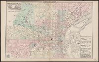
Alternative Title:
Philadelphia and vicinity [cartographic material]. and Rand McNally & Co.'s map showing one hundred miles around Philadelphia.
Description:
Inset map on recto: Philadelphia and vicinity. Scale [ca. 1:116 000].
Publisher:
Rand, McNally & Co.,
Subject (Geographic):
Middle Atlantic States--Maps, Philadelphia (Pa.)--Maps, and Philadelphia Metropolitan Area (Pa.)--Maps
Found in:
Beinecke Rare Book and Manuscript Library > The Rand-McNally new commercial atlas map of Philadelphia / Rand McNally & Co., map publisher and engravers.
Creator:
Published / Created:
ca. 1916.
Call Number:
774 P53 1916
Container / Volume:
BRBL_00500
Image Count:
2
Resource Type:
Maps, Atlases & Globes
Description:
Imperfect: Mutilated, with some loss of text. Ms. annotations.
Publisher:
Royal Pub. Co.,
Subject (Geographic):
Philadelphia (Pa.)--Maps
Found in:
Beinecke Rare Book and Manuscript Library > The up-to-date complete map of Philadelphia and vicinity / by A.J. Robb ; Royal Publishing Co. Distributers.
Published / Created:
1811
Call Number:
774 P53 1811
Container / Volume:
BRBL_00499
Image Count:
1
Resource Type:
Maps, Atlases & Globes
Description:
W. Harrison Sct. Drawn by Wm. Strickland.
Publisher:
C.P. Harrison,
Subject (Geographic):
Philadelphia (Pa.)--Maps
Found in:
Beinecke Rare Book and Manuscript Library > To the Citizens of Philadelphia, This New Plan of the City and its Environs, Taken from actual Survey is Respectfully Dedicated by their Humble Servt. John A. Paxton.
Branch:v1.68.6 ,Deployed:2025-07-02T08:09:52-04:00