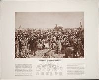
The print reproduces Thomas Hill's painting "Driving the last spike" above a key to seventy-one of the persons represented in the painting; also, a short essay by the historian Richard Dillon
Description:
At foot of sheet: Published by The Nut Tree to commemorate the centennial anniversary of the "Driving of the last spike," Nut Tree, California, 95688.
Publisher:
The Nut Tree
Subject (Geographic):
Utah
Subject (Name):
Central Pacific Railroad Company and Union Pacific Railroad Company
Viewbook of mounted photographic prints compiled by the George W. Williams & Company, fertilizer merchants, ca. 1869. A photographic print appears on the recto of each mount that depicts an advertisement for Carolina Fertilizer with a letterpress tes...
Description:
Title from cover.
Publisher:
s.n.
Subject (Geographic):
United States., West (U.S.), Coalville (Utah), Echo (Utah), Laramie (Wyo.), Missouri River, Nebraska, Omaha (Neb.), Salt Lake City (Utah), Utah, Weber River Valley (Utah), and Wyoming
Subject (Name):
Russell, Andrew J., Williams, George Walton, 1820-1903., Young, Brigham, 1801-1877, Beehive House (Salt Lake City, Utah), Central Pacific Railroad Company, Lion House (Salt Lake City, Utah), Tabernacle (Salt Lake City, Utah), and Union Pacific Railroad Company
Subject (Topic):
Homes and haunts, Advertising, Agriculture, Fertilizer industry, and Railroads
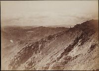
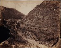
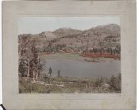
Photographs created from mammoth plate negatives primarily by photographers Carleton E. Watkins and William Henry Jackson of various locations in the American West, primarily in the states of California, Colorado, and Oregon, as well as Arizona, Monta...
Description:
A mammoth plate is a photographic negative plate, 18 by 21 inches (53.5 x 45.7 cm.) or larger, from which photographic prints are made through contact printing.
Subject (Geographic):
Wyoming, Montana, West (U.S.), Arizona, Arkansas River, Austin Bluffs (Colo.), Black Canyon of the Gunnison (Colo.), Blue Lakes (Calif.), Bridal Veil Falls (Utah), California, Cathedral Rocks (Calif.), Cathedral Spires (El Paso County, Colo.), Cathedral Spires (Jefferson County, Colo.), Clear Creek Canyon (Colo.), Clear Creek County (Colo.), Cochise Stronghold (Ariz.), Colorado, Columbia River, Costilla County (Colo.), Curecanti Needle (Colo.), Dalles (Or.), Dragoon Mountains (Ariz.), Drumlummon Mine (Mont.), Eagle Creek (Or.), Echo (Utah), El Capitan (Calif.), El Paso County (Colo.), Fountain Creek (Colo.), Fremont County (Colo.), Garden of the Gods (Colorado Springs, Colo.), Garfield County (Colo.), Gate Rock (El Paso County, Colo.), Giant Geyser (Wyo.), Glenwood Springs (Colo.), Grotto Geyser (Wyo.), Gunnison County (Colo.), Gunnison River (Colo.), Half Dome (Calif.), Jefferson County (Colo.), Jerome County (Idaho), Lake Vineyard (San Gabriel, Calif.), Marysville (Lewis and Clark County, Mont.), Mokelumne River (Calif.), Monument Park (El Paso County, Colo.), Multnomah County (Or.), Multnomah Creek (Or.), Multnomah Falls (Or.), North Cheyenne Canyon (Colo.), North Cheyenne Creek (Colo.), North Fork American River (Calif.), Old Faithful Geyser (Wyo.), Oregon, Palisades Falls, Pikes Peak (Colo.), Platte Canyon (Colo.), Port Ludlow (Wash.), Port Madison (Bainbridge Island, Wash.), Provo Canyon (Utah), Provo River (Utah), Pulpit Rock (Utah), Pulpit Terrace (Wyo.), Rainbow Falls (Colo.), Rio Arriba County (N.M.), Rio de los Pinos (Colo. and N.M.), Round Top Mountain (Calif.), Royal Gorge (Colo.), San Gabriel (Calif.), Sentinel Rock (Calif.), Seven Falls (Colo.), Sierra Blanca (Colo.), Snake River (Wyo.-Wash.), Soda Springs (Calif.), South Cheyenne Canyon (Colo.), South Cheyenne Creek (Colo.), South Platte River (Colo. and Neb.), Spokane (Wash.), Spokane River (Idaho and Wash.), Teller County (Colo.), Toltec Gorge (N.M.), Tombstone (Ariz.), Tombstone Region (Ariz.), Twin Creek (Colo.), Twin Falls (Idaho : Waterfalls), Utah, Ute Pass (Teller County, Colo.), Washington (State), Yampah Hot Springs (Colo.), Yellowstone National Park, Yosemite National Park (Calif.), and Yosemite Valley (Calif.)
Subject (Name):
Haynes, F. Jay 1853-1921. (Frank Jay),, Jackson, William Henry, 1843-1942., Meeker, Ezra, 1830-1928., Watkins, Carleton E., 1829-1916., Colorado Central Railroad Company, Denver and Rio Grande Railroad Company, Denver, South Park, and Pacific Railroad Company, Mission San Gabriel Arcangel (San Gabriel, Calif.), and Tough Nut Mine
Subject (Topic):
Geysers, Landscape photography, Mineral industries, and Railroads
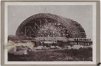
Photograph album of cabinet card views of Salt Lake City, Fort Douglas, Green River and Ogden, Utah, and studio portraits of Ute and Sioux Indians. Salt Lake City views include the Triumphal Arch, the Eagle Gate, the City and County Building, the Mor...
Description:
Cabinet cards, cartes-de-visite (1) and stereographs (5), many with advertisments on versos, some accompanied by manuscript captions.
Subject (Geographic):
Utah, Salt Lake City (Utah), Fort Douglas (Utah), Green River (Utah), and Ogden (Utah)
Subject (Topic):
Indians of North America, Ute Indians, Dakota Indians, and Mormons
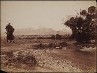
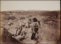
Photographic prints of images created by Andrew Joseph Russell of locations in Utah, Wyoming, California, and Nebraska, ca. 1867-1869. The bound album contains the same images represented in the loose photographic prints. the loose photographic print...
Description:
Title devised by cataloger.
Subject (Geographic):
Utah, Salt Lake City., West (U.S.), Bear River (Utah-Idaho), Buford (Wyo.), California, Coalville (Utah), Dale Creek (Colo. and Wyo.), Donner Lake (Calif.), Dutch Flat (Calif.), Echo (Utah), Echo Canyon (Utah), Green River (Wyo.-Utah), Green River Valley (Wyo.-Utah), Grizzly Peak (Wyo.), Henefer (Utah), Laramie Basin (Wyo.), Laramie Mountains (Colo. and Wyo.), Laramie River (Colo. and Wyo.), Nebraska, North Platte River, One Thousand Mile Tree (Utah : Tree), Parley Canyon (Utah), Platte River (Neb.), Promontory (Utah), Salt Lake City (Utah), Sherman (Wyo.), Sierra Nevada (Calif. and Nev.), Temple Street (Salt Lake City, Utah), Uinta Mountains (Utah and Wyo.), Wasatch Range (Utah and Idaho), Weber River (Utah), Weber River Valley (Utah), White Pine Canyon (Summit County, Utah), Wilhelmina Pass (Utah), Witch Rocks (Utah), and Wyoming
Subject (Name):
Russell, Andrew J., Young, Brigham, 1801-1877, Beehive House (Salt Lake City, Utah), Lion House (Salt Lake City, Utah), Salt Lake Theatre, Tabernacle (Salt Lake City, Utah), Union Pacific Railroad Company, and Zion's Co-operative Mercantile Institution
Subject (Topic):
Homes and haunts, Bridges, Wooden, Hot springs, and Railroads