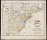
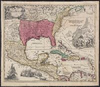
Treize Etats Unis de l'Amerique septentrionale, d'apress les meilleurs & speciales cartes angloises qui ont parues jusqu'ici and XIII Etats Unis de l'Amerique septentrionale, d'apres les meilleurs & speciales cartes angloises qui ont parues jusqu'ici
Description:
"I.M. Schmidt, sc. Nor.", "Mit Römisch Kaÿserl. Allerg. Freÿheit.", Backed with linen., Bar scales given in "Geographische Meilen," "See-Meilen 20 auf einen Grad.," and "Englaendil. Meilen.", Prime meridian: Ferro., and Relief shown pictorially.
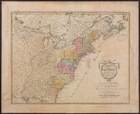
Treize Etats Unis de l'Amerique septentrionale, d'apress les meilleurs & speciales cartes angloises qui ont parues jusqu'ici and XIII Etats Unis de l'Amerique septentrionale, d'apres les meilleurs & speciales cartes angloises qui ont parues jusqu'ici
Description:
"I.M. Schmidt, sc. Nor.", "Mit Römisch Kaÿserl. Allerg. Freÿheit.", Bar scales given in "Geographische Meilen," "See-Meilen 20 auf einen Grad.," and "Englaendil. Meilen.", and Franklin Collection no. 131 1784-7. Sheet measures 54.5 x 67.1 cm.
Copy 2: Hand col. Mounted on linen. Sheet measures 52.1 x 59.8 cm., Includes notes and ill., Relief shown pictorially., and Some references suggest earlier possible imprint date.
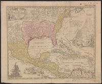
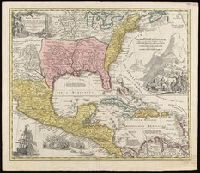
Appears in Homann's Atlas geographicus major ... Normibergae : Curantibus Homannianis heredibus, 1759., Includes notes, ill. of ships in battle, and of Europeans and Native Americans, and four bar scales., Ms. annotations. Ms. no. on verso: 207 III 59. Sheet measures 53.6 x 64.9 cm. Franklin Collection no. 131 1737-2., Relief shown pictorially., Some references suggest earlier possible imprint date., and This edition is at least the second state, as Ludoviciana has replaced Florida as the name of the Louisiana territory.
Publisher:
[Homann Erben?,
Subject (Geographic):
NorthAmerica--Maps--Early works to
Subject (Name):
Homann Erben (Firm) and Homann, Johann Baptist, 1663-1724. Atlas geographicus major
Appears in Homann's Atlas geographicus major ... Normibergae : Curantibus Homannianis heredibus, 1759., Copy 2: Watermark. Manuscript number on verso, "28." Sheet measures 53 x 61 cm. Cross Collection no. 237., Includes notes, ill. of ships in battle, and of Europeans and Native Americans, and four bar scales., Relief shown pictorially., Some references suggest earlier possible imprint date., and This edition is at least the second state, as Ludoviciana has replaced Florida as the name of the Louisiana territory.
Publisher:
[Homann Erben?,
Subject (Geographic):
NorthAmerica--Maps--Early works to
Subject (Name):
Homann Erben (Firm) and Homann, Johann Baptist, 1663-1724. Atlas geographicus major.
Appears in Homann's Atlas geographicus major ... Normibergae : Curantibus Homannianis heredibus, 1759., Copy 1: Ms. no. on verso: 107. Stamp on verso: Yale, Horace Brown, 1900S. Neat line measures 47.6 x 57.5 on sheet 52 x 62 cm., and Includes notes, ill. of sh
Publisher:
[Homann Erben?,
Subject (Geographic):
NorthAmerica--Maps--Early works to
Subject (Name):
Homann Erben (Firm) and Homann, Johann Baptist, 1663-1724. Atlas geographicus major
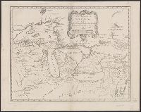
Covers the area from Lake Superior to Kaskaskia and from Delaware Bay to the Mississippi River., Relief shown pictorially., Shows a few towns, missions, forts, Indian villages and tribal territory, rivers and lakes, portages, and early place-names., and Watermark.
Covers the area from Lake Superior to Kaskaskia and from Delaware Bay to the Mississippi River., Relief shown pictorially., Shows a few towns, missions, forts, Indian villages and tribal territory, rivers and lakes, portages, and early place-names., and Watermark.
Publisher:
[Homann Erben?],
Subject (Geographic):
Great Lakes Region (NorthAmerica
Subject (Name):
Brown, Horace--Stamp, Homann Erben (Firm), and Thorne Collection of Cartogaphy and Geography Stamp