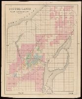
Backed with linen. Manuscript annotations on map. Manuscript title on verso: Portage Lake. From the Richard H. Rickard Papers. and Coordinates not present on map and are approximated.
Publisher:
[publisher not identified],
Subject (Geographic):
Keweenaw Peninsula (Mich.)--Maps.
Subject (Name):
Rickard, Richard H.,---1885--Ownership. and St. Mary's Canal Mineral Land Company--Maps.
Subject (Topic):
Copper mines and mining--Michigan--Keweenaw Peninsula--Maps.
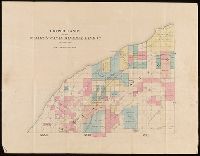
Backed with linen. Manuscript annotations on map. Manuscript title on verso: Eagle River & Cliff Mine District. From the Richard H. Rickard Papers. and Coordinates not present on map and are approximated.
Publisher:
[publisher not identified],
Subject (Geographic):
Keweenaw County (Mich.)--Maps.
Subject (Name):
Rickard, Richard H.,---1885--Ownership. and St. Mary's Canal Mineral Land Company--Maps.
Subject (Topic):
Copper mines and mining--Michigan--Keweenaw County--Maps.
Backed with linen. Manuscript annotations on map. Manuscript title on verso: Ontonagon village & Minnesota mine. From the Richard H. Rickard Papers. and Coordinates not present on map and are approximated.
Publisher:
[publisher not identified],
Subject (Geographic):
Ontonagon County (Mich.)--Maps.
Subject (Name):
Rickard, Richard H.,---1885--Ownership. and St. Mary's Canal Mineral Land Company--Maps.
Subject (Topic):
Copper mines and mining--Michigan--Ontonagon County--Maps.
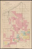
Backed with linen. Manuscript annotations on map. Manuscript title on verso: Copper Harbour & Eagle Harbour. From the Richard H. Rickard Papers. and In upper left corner: 59.
Publisher:
[publisher not identified],
Subject (Geographic):
Keweenaw County (Mich.)--Maps. and Michigan--Keweenaw County
Subject (Name):
Delaware Mining Company of Michigan--Maps., Friend, Norman M., approximately 1815-, Pennsylvania Mining Company of Michigan--Maps., and Rickard, Richard H.,---1885--Ownership.
Subject (Topic):
Copper mines and mining, Copper mines and mining--Michigan--Keweenaw County--Maps., Landowners, Landowners--Michigan--Keweenaw County--Maps., Mines and mineral resources, and Mines and mineral resources--
Map showing the route by road & navigation for connecting the Atlantic and Pacific Oceans
Description:
"Statement of distances by land and water, respectively, between Thunder Bay, Lake Superior, and Fort Langley, on Frazer's River.", From the Richard H. Rickard Papers., From: Report on the Exploration of the Country between Lake Superior and the Red River Settlement ... By S.J. Dawson, 1859., and Relief shown by hachures.
Publisher:
J. Ellis,
Subject (Geographic):
Canada and Canada--Discovery and exploration--Maps.
Subject (Name):
Dawson, S. J. (Simon James), 1820-1902. Report on the Exploration of the Country between Lake Superior and the Red River Settlement. and Rickard, Richard H.,---1885--Ownership.