Skip to search
Skip to main content
Skip to first result
Search
You Searched For
Extent of Digitization
Completely digitized
Subject (Topic)
Forests and forestry--Oregon--Coos County--Maps
Search Results
Creator:
Published / Created:
[1900]
Call Number:
846gc C786 1896
Container / Volume:
BRBL_00623
Image Count:
1
Resource Type:
Maps, Atlases & Globes
Alternative Title:
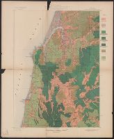
Coos Bay quadrangle, Oregon, land classification and density of standing timber.
Description:
"Julius Bien & Co. Lith. N.Y."
Publisher:
The Survey,
Subject (Geographic):
Coos County (Or.)--Maps
Subject (Name):
Barnard, E. C. (Edward Chester), 1863-1921, Gannett, Henry, 1846-1914, Geological Survey (U.S.). Annual report, and Johnson, A. J
Subject (Topic):
Forests and forestry--Oregon--Coos County--Maps and Land capability for agriculture--Oregon--Coos County--Maps
Found in:
Beinecke Rare Book and Manuscript Library > Oregon, Coos Bay quadrangle : land classification and density of standing timber / U.S. Geological Survey ; R.U. Goode, geographer in charge ; triangulation by W.T. Griswold ; topography by E.C. Barnard ; Henry Gannett, geographer in charge ; land classif
Creator:
Published / Created:
[1900].
Call Number:
846gc P838 1898
Container / Volume:
BRBL_00623
Image Count:
1
Resource Type:
Maps, Atlases & Globes
Alternative Title:
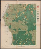
Port Orford quadrangle, Oregon, land classification and density of standing timber.
Description:
"Julius Bien & Co. Lith. N.Y."
Publisher:
The Survey,
Subject (Geographic):
Coos County (Or.)--Maps and Curry County (Or.)--Maps
Subject (Name):
Geological Survey (U.S.). Annual report, Johnson, A. J, and Murlin, A. E
Subject (Topic):
Forests and forestry--Oregon--Coos County--Maps, Forests and forestry--Oregon--Curry County--Maps, Land capability for agriculture--Oregon--Coos County--Maps, and Land capability for agriculture--Oregon--Curry County--Maps
Found in:
Beinecke Rare Book and Manuscript Library > Oregon, Port Orford quadrangle : land classification and density of standing timber / U.S. Geological Survey ; R.U. Goode, geographer in charge ; triangulation by W.T. Griswold ; topography by A.E. Murlin ; Henry Gannett, geographer in charge ; land class
Branch:v1.68.6 ,Deployed:2025-07-02T08:09:50-04:00