Skip to search
Skip to main content
Skip to first result
Search
You Searched For
Extent of Digitization
Completely digitized
Subject (Topic)
Maps
Search Results
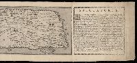
Creator:
Published / Created:
[1715]
Call Number:
1973 Folio 18
Image Count:
1
Description:
BEIN 1973 Folio 18: Imperfect: torn along left fold, with no loss of text. Backed with paper. Ms. no. "11" in upper right-hand corner. Sheet measures 53.5 x 61.6 cm. No. 10 of 87 maps bound together.
Publisher:
Chez Pierre Husson
Subject (Geographic):
Stralsund (Germany), Germany, and Mecklenburg (Region)
Subject (Topic):
Northern War, 1700-1721, Campaigns, and Maps
Found in:
Beinecke Rare Book and Manuscript Library > Strahlsundt investi le 15 juillet 1715 [cartographic material]
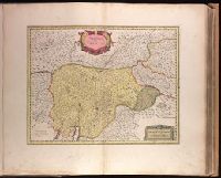
Creator:
Published / Created:
[ca. 1631]
Call Number:
1973 Folio 18
Image Count:
1
Description:
BEIN 1973 Folio 18: Backed with paper. Ms. no. in upper right corner: 16. Sheet measures 53.6 x 63.0 cm. No. 16 of 87 maps bound together.
Publisher:
Apud Guiljelmus Blaeuw
Subject (Geographic):
Trento (Italy)
Subject (Topic):
Maps
Found in:
Beinecke Rare Book and Manuscript Library > Territorio di Trento [cartographic material].
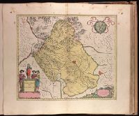
Creator:
Published / Created:
1647?]
Call Number:
1973 Folio 18
Image Count:
1
Description:
BEIN 1973 Folio 18: Backed with paper. Ms. no. "71" in upper right corner. Sheet measures 53.7 x 62.1 cm. No. 66 of 87 maps bound together.
Publisher:
Joan Blaeu
Subject (Geographic):
Vicenza (Italy : Province)
Subject (Topic):
Maps
Found in:
Beinecke Rare Book and Manuscript Library > Territorio di Vicenza [cartographic material].
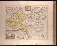
Creator:
Published / Created:
ca. 1670]
Call Number:
1973 Folio 18
Image Count:
1
Alternative Title:
Territorivm Basileense, cum adjacentibus
Description:
BEIN 1973 Folio 18: Backed with paper. Ms. no. in upper right corner: 17. Sheet measures 53.7 x 62.7 cm. No. 17 of 87 maps bound together.
Publisher:
Joan Blaeu
Subject (Geographic):
Basel-Stadt (Switzerland) and Haut-Rhin (France)
Subject (Topic):
Maps
Found in:
Beinecke Rare Book and Manuscript Library > Territorium Basileense, cum adjacentibus [cartographic material].
Creator:
Published / Created:
[163-]
Call Number:
1973 Folio 18
Image Count:
1
Alternative Title:
Territorivm Metense and Pais Messin
Description:
BEIN 1973 Folio 18: Backed with paper. Ms. no. "57" in upper-right corner. Sheet measures 53.7 x 63.6 cm. No. 52 of 87 maps bound together.
Publisher:
Apud Guiljelmum et Johannem Blaeuw
Subject (Geographic):
Moselle (France)
Subject (Topic):
Maps
Found in:
Beinecke Rare Book and Manuscript Library > Territorium Metense le Pais Messin / [cartographic material]
Creator:
Published / Created:
[23 June 1787]
Call Number:
Auchincloss Gillray v. 2
Image Count:
1
Resource Type:
still image
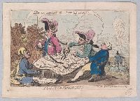
Abstract:
"Four monarchs divide between them a map of the territories of the Dutch Republic, all saying, "Let us support the poor Dutch!" In the background (left) the 'Stadt House' falls in ruins, and on a small rock in the sea inscribed 'Texel' a fat Dutchman ...
Description:
Title etched below image
Publisher:
Pubd. June 23d, 1787, by S.W. Fores, No. 3 Piccadilly
Subject (Name):
George III, King of Great Britain, 1738-1820, Louis XVI, King of France, 1754-1793, Joseph II, Holy Roman Emperor, 1741-1790, and Frederick William II, King of Prussia, 1744-1797
Subject (Topic):
Maps, Daggers & swords, Scissors & shears, Pipes (Smoking), Geese, and Ethnic stereotypes
Found in:
Beinecke Rare Book and Manuscript Library > The Dutch divisions [graphic].