Skip to search
Skip to main content
Skip to first result
Search
You Searched For
Extent of Digitization
Completely digitized
Subject (Topic)
Railroads--Indian Territory--Maps
Search Results
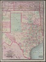
Creator:
Published / Created:
1877
Call Number:
796 1877A
Container / Volume:
BRBL_00526
Image Count:
3
Resource Type:
Maps, Atlases & Globes
Alternative Title:
New county and railroad map of Texas and Indian Territory and New railroad and township map of Texas and Indian Territ'y
Description:
"Entered according to act of Congress in the year 1873 by G.F. Cram in the office of the librarian of Congress at Washington, D.C."
Publisher:
George F. Cram,
Subject (Geographic):
Indian Territory--Maps, Texas--Administrative and political divisions--Maps, and Texas--Maps
Subject (Topic):
Railroads--Indian Territory--Maps and Railroads--Texas--Maps
Found in:
Beinecke Rare Book and Manuscript Library > Cram's new county and railroad map of Texas and Indian Territory : showing latest government surveys &c &c / Geo. F. Cram, lith.
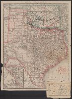
Creator:
Published / Created:
1886
Call Number:
796 1886A
Container / Volume:
BRBL_00526
Image Count:
1
Resource Type:
Maps, Atlases & Globes
Alternative Title:
Rand, McNally & Co.'s Texas and Indian Territory and Texas and the Indian Territory
Description:
Includes map of western portion of Texas.
Publisher:
Rand, McNally & Co.,
Subject (Geographic):
Indian Territory--Maps, Texas--Administrative and political divisions--Maps, and Texas--Maps
Subject (Topic):
Railroads--Indian Territory--Maps, Railroads--Texas--Denison--Maps, and Railroads--Texas--Maps
Found in:
Beinecke Rare Book and Manuscript Library > Map of Texas and the Indian Territory.
Creator:
Published / Created:
[1883?]
Call Number:
826 1883
Container / Volume:
BRBL_00577
Image Count:
1
Resource Type:
Maps, Atlases & Globes
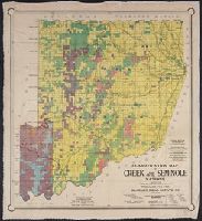
Description:
Cherokee Outlet labeled "Unknown nation."
Publisher:
Geo. Fr. Cram,
Subject (Geographic):
Indian Territory--Maps
Subject (Topic):
Railroads--Indian Territory--Maps
Found in:
Beinecke Rare Book and Manuscript Library > Railroad and county map of Indian Ty.
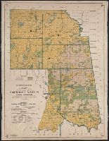
Creator:
Published / Created:
1902
Call Number:
827gme 1902
Container / Volume:
BRBL_00578
Image Count:
2
Resource Type:
Maps, Atlases & Globes
Alternative Title:
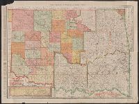
New business map of Indian Territory and Oklahoma., Oklahoma and Indian Territory, and Rand McNally & Company's new business map of Indian Territory and Oklahoma.
Description:
Below scale: Rand, McNally & Co.'s new business map of Indian Territory and Oklahoma.
Publisher:
Rand McNally,
Subject (Geographic):
Indian Territory--Maps and Oklahoma--Maps
Subject (Topic):
Railroads--Indian Territory--Maps and Railroads--Oklahoma--Maps
Found in:
Beinecke Rare Book and Manuscript Library > Rand, McNally & Co.'s Oklahoma and Indian Territory.
Branch:v1.68.6 ,Deployed:2025-07-02T08:09:49-04:00