Skip to search
Skip to main content
Skip to first result
Search
You Searched For
Extent of Digitization
Completely digitized
Subject (Topic)
Railroads--West (U.S.)--Maps
Search Results
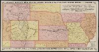
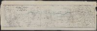
Published / Created:
1877?]
Call Number:
80gme 1877B
Container / Volume:
BRBL_00539
Image Count:
2
Resource Type:
Maps, Atlases & Globes
Alternative Title:
Kansas Pacific Railway
Description:
Advertisements, text, and timetables on verso.
Publisher:
s.n.,
Subject (Name):
Kansas Pacific Railway Company, Kansas Pacific Railway Company--Maps, and Woodward, Tiernan, and Hale
Subject (Topic):
Railroads--West (U.S.)--Maps
Found in:
Beinecke Rare Book and Manuscript Library > A geographically correct map of the Kansas Pacific Railway : showing the only direct route to Denver and all the popular Rocky Mountain resorts, also to the Black Hills country and the famous San Juan mines in Colorado / Woodward, Tiernan & Hale, map engr
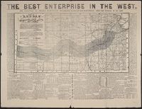
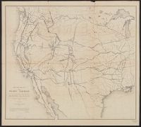
Published / Created:
1873?]
Call Number:
825gme 1873
Container / Volume:
BRBL_00576
Image Count:
2
Resource Type:
Maps, Atlases & Globes
Alternative Title:
Atchison, Topeka and Santa-Fe Railroad and connections., Best enterprise in the West., and Map of Kansas.
Description:
Date inferred from references to 1873 in text.
Publisher:
s.n.,
Subject (Geographic):
Kansas--Maps
Subject (Name):
Atchison, Topeka, and Santa Fe Railroad Company, Atchison, Topeka, and Santa Fe Railroad Company--Maps, Bogart & Stillman, Fisk & Russell, and Poor, C
Subject (Topic):
Railroad land grants--Kansas--Maps, Railroads--Kansas--Maps, and Railroads--West (U.S.)--Maps
Found in:
Beinecke Rare Book and Manuscript Library > Atchison, Topeka & Santa-Fe Railroad and connections : with 3,000,000 acres land for sale on eleven years credit & seven percent interest / Fisk & Russell, N.Y. Map of Kansas / Atchison, Topeka & Santa-Fe Railroad ; Bogart & Stillman, engravers, Cin. O.
Creator:
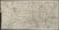
Published / Created:
1899
Call Number:
80gme 1899
Container / Volume:
BRBL_00539
Image Count:
1
Resource Type:
Maps, Atlases & Globes
Alternative Title:
Chicago, Burlington and Quincy railroad system
Description:
Covers area from Colorado to Lake Michigan, through South Dakota, Minnesota, Wisconsin, Nebraska, Iowa, Illinois, and northern Kansas and Missouri.
Publisher:
Rand McNally & Co.,
Subject (Name):
Chicago, Burlington & Quincy Railroad Company and Chicago, Burlington & Quincy Railroad Company--Maps
Subject (Topic):
Railroads--Middle West--Maps and Railroads--West (U.S.)--Maps
Found in:
Beinecke Rare Book and Manuscript Library > Chicago, Burlington & Quincy railroad system.
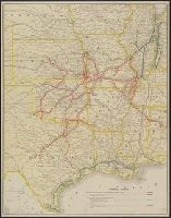
Published / Created:
June 30, 1912.
Call Number:
80gme 1912C
Container / Volume:
BRBL_00540
Image Count:
1
Resource Type:
Maps, Atlases & Globes
Description:
Covers area defined by Nebraska and Iowa to the north and Texas on the south; and the Kansas-Colorado border to the west and Alabama to the east.
Publisher:
Parker Engraving Co.?],
Subject (Name):
Chicago & Eastern Illinois Railroad Company--Maps, Houston & Texas Central Railway Company--Maps, New Orleans, Texas & Mexico Railroad Company--Maps, Parker Eng. Co, and St. Louis-San Francisco Railway Company--Maps
Subject (Topic):
Railroads--West (U.S.)--Maps
Found in:
Beinecke Rare Book and Manuscript Library > Frisco lines.
Creator:
Published / Created:
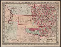
1859
Call Number:
825 1859
Container / Volume:
BRBL_00573
Image Count:
1
Resource Type:
Maps, Atlases & Globes
Alternative Title:
Johnson's new railroad and county copper plate map of Kansas gold region and the Great West, from the latest and best authorities, New, and New rail road and county copper plate map of Kansas gold region and the Great West, from the latest and best authorities
Description:
"Entered according to act of Congress in the year 1859 by A.J. Johnson in the clerks office of the district court of the United States for the southern district of New
Publisher:
Johnson & Browning,
Subject (Geographic):
Kansas--Maps and West (U.S.)--Maps
Subject (Name):
Johnson & Browning
Subject (Topic):
Colorado--Gold discoveries--Maps, Gold mines and mining--Colorado--Maps, and Railroads--West (U.S.)--Maps
Found in:
Beinecke Rare Book and Manuscript Library > Johnson's new rail road and county copper plate map of Kansas gold region and the Great West, from the latest and best authorities.
Branch:v1.68.6 ,Deployed:2025-07-02T08:09:21-04:00