Search
You Searched For
Search Results
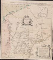
- Creator:
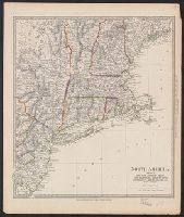
- Pownall, Thomas, 1722-1805
- Published / Created:
- March 25th, 1776.
- Call Number:
- 71 1776N
- Container / Volume:
- BRBL_00726
- Image Count:
- 4
- Resource Type:
- Maps, Atlases & Globes
- Found in:
- Beinecke Rare Book and Manuscript Library > A map of the middle British colonies in North America [cartographic material] : First published by Lewis Evans, of Philadelphia, in 1755 ; and since corrected and improved, as also extended, with the addition of New England, and bordering parts of Canada
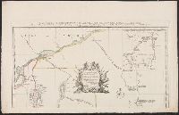
- Creator:
- Pownall, Thomas, 1722-1805
- Published / Created:
- March 25th, 1776.
- Call Number:
- 755 1776P
- Container / Volume:
- BRBL_00430
- Image Count:
- 1
- Resource Type:
- Maps, Atlases & Globes
- Found in:
- Beinecke Rare Book and Manuscript Library > A map of the middle British colonies in North America [cartographic material] : First published by Lewis Evans, of Philadelphia, in 1755 ; and since corrected and improved, as also extended, with the addition of New England, and bordering parts of Canada
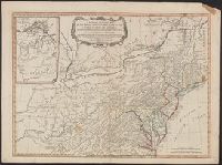
- Creator:
- Pownall, Thomas, 1722-1805
- Published / Created:
- March 25th, 1776.
- Call Number:
- 71 1776N
- Container / Volume:
- BRBL_00726
- Image Count:
- 1
- Resource Type:
- Maps, Atlases & Globes
- Found in:
- Beinecke Rare Book and Manuscript Library > A map of the middle British colonies in North America [cartographic material] : First published by Lewis Evans, of Philadelphia, in 1755 ; and since corrected and improved, as also extended, with the addition of New England, and bordering parts of Canada
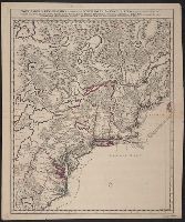
- Creator:
- Jefferys, Thomas, -1771
- Published / Created:
- 15 June 1775.
- Call Number:
- 732 1775
- Container / Volume:
- BRBL_00727
- Image Count:
- 1
- Resource Type:
- Maps, Atlases & Globes
- Subject (Geographic):
- New England--Maps--Early works to 1800
- Found in:
- Beinecke Rare Book and Manuscript Library > A new map of Nova Scotia, and Cape Breton Island : with the adjacent parts of New England and Canada, composed from a great number of actual surveys; and other materials regulated by many new astronomical observations of the longitude as well as latitude
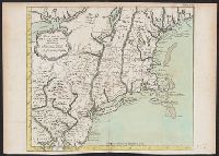
- Creator:
- Blanchard, Joseph, d. 1758
- Published / Created:
- 1761
- Call Number:
- 762 1761B
- Container / Volume:
- BRBL_00450
- Image Count:
- 1
- Resource Type:
- Maps, Atlases & Globes
- Found in:
- Beinecke Rare Book and Manuscript Library > An accurate map of His Majesty's province of New-Hampshire in New England : taken from actual surveys of all the inhabited part, and from the best information of what is uninhabited, together with the adjacent countries, which exhibits the theatre of this
- Creator:
- Blanchard, Joseph, d. 1758
- Published / Created:
- 1761
- Call Number:
- 762 1761
- Container / Volume:
- BRBL_00450
- Image Count:
- 2
- Resource Type:
- Maps, Atlases & Globes
- Found in:
- Beinecke Rare Book and Manuscript Library > An accurate map of His Majesty's Province of New-Hampshire in New England, taken from actual surveys of all the inhabited part, and from the best information of what is uninhabited, together with the adjacent countries, which exhibits the theatre of this
- Published / Created:
- 1794
- Call Number:
- 755 1794A
- Container / Volume:
- BRBL_00436
- Image Count:
- 1
- Resource Type:
- Maps, Atlases & Globes
- Found in:
- Beinecke Rare Book and Manuscript Library > A new and general map of the middle dominions belonging to the United States of America, viz. Virginia, Maryland, the Delaware-Counties, Pennsylvania, New Jersey &c., with the addition of New York, & of the greatest part of New England &c. as also of the
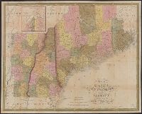
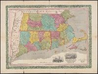
- Creator:
- Mitchell, S. Augustus (Samuel Augustus), 1792-1868
- Published / Created:
- 1847
- Call Number:
- 76 1847A
- Container / Volume:
- BRBL_00445
- Image Count:
- 1
- Resource Type:
- Maps, Atlases & Globes
- Subject (Geographic):
- New England--Maps
- Found in:
- Beinecke Rare Book and Manuscript Library > Map of Maine, New Hampshire, and Vermont : compiled from the latest authorities / published by S. Augustus Mitchell ; J.H. Young Sc. ; sold by Thomas, Cowperthwait & Co.
- Creator:
- Society for the Diffusion of Useful Knowledge (Great Britain)
- Published / Created:
- 1832
- Call Number:
- 755 1832A
- Container / Volume:
- BRBL_00440
- Image Count:
- 1
- Resource Type:
- Maps, Atlases & Globes
- Subject (Geographic):
- New England--Maps
- Found in:
- Beinecke Rare Book and Manuscript Library > North America. Sheet VI, New-York, Vermont, Maine, New-Hampshire, Massachusetts, Connecticut, Rhode-Island, and New-Jersey / published by the Society for the Diffusion of Useful Knowledge.
- Creator:
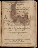
- Thacher, Thomas, 1620-1678, author
- Published / Created:
- 1678.
- Call Number:
- Pequot Z96
- Image Count:
- 32
- Resource Type:
- text
- Found in:
- Beinecke Rare Book and Manuscript Library > A fast of Gods chusing plainly opened for the help of those poor in spirit whose hearts are set to seek the Lord their God in New-England in the solemn ordinance of a fast : wherein is shewed 1. The nature of such a fast. 2. The testimony God will give thereunto of his gracious acceptation 3. The special seasons wherein God will bear witness to such a fast. 4. Some helps to faith that it shall be so. 5. Why such a fast is so acceptable and successfull. 6. How much this concerns Gods people in New-England
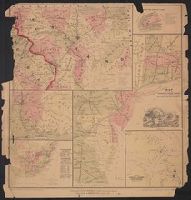
- Published / Created:
- 1861
- Call Number:
- 754 1861
- Container / Volume:
- BRBL_00416
- Image Count:
- 1
- Resource Type:
- Maps, Atlases & Globes
- Subject (Geographic):
- New England--Maps
- Found in:
- Beinecke Rare Book and Manuscript Library > Map showing the R.R. Routes, Coast Lines, and Forts, between Boston & Norfolk Harbor.
- Creator:
- Bulkeley, Peter, 1583-1659
- Published / Created:
- 1653
- Call Number:
- Mhc9 B871 G6 1653
- Image Count:
- 230
- Found in:
- Beinecke Rare Book and Manuscript Library > The gospel-covenant, or, The covenant of grace opened : wherein are explained; 1. The differences betwixt the covenant of grace and covenant of workes. 2. The different administration of the covenant before and since Christ. 3. The benefits and blessings of it. 4. The condition. 5. The properties of it / preached in Concord in New-England, by Peter Bulkeley ...
- Creator:
- Horace Thayer & Co
- Published / Created:
- 1853
- Call Number:
- 76 1853
- Container / Volume:
- BRBL_00445
- Image Count:
- 1
- Resource Type:
- Maps, Atlases & Globes
- Subject (Geographic):
- New England--Maps
- Found in:
- Beinecke Rare Book and Manuscript Library > Rail-road & township map of Massachusetts, Connecticut and Rhode Island.
- Published / Created:
- [1675?]
- Call Number:
- 755 1675A
- Container / Volume:
- BRBL_00423
- Image Count:
- 1
- Resource Type:
- Maps, Atlases & Globes
- Subject (Geographic):
- New England--Maps--Early works to 1800
- Found in:
- Beinecke Rare Book and Manuscript Library > Nova tabula geographica complectens Borealiorem Americæ partem ... / Luggardus van Anse schulp.
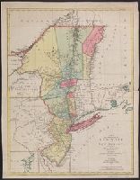
- Creator:
- Bellin, Jacques Nicolas, 1703-1772
- Published / Created:
- 1764].
- Call Number:
- 755 1764
- Container / Volume:
- BRBL_00429
- Image Count:
- 1
- Resource Type:
- Maps, Atlases & Globes
- Subject (Geographic):
- New England--Maps--Early works to 1800
- Found in:
- Beinecke Rare Book and Manuscript Library > Carte de la Nouvelle Angleterre : New York, Pensilvanie et Nouveau Jersay suivant les cartes angloises.
- Published / Created:
- 1777
- Call Number:
- 755 1777S
- Container / Volume:
- BRBL_00728
- Image Count:
- 1
- Resource Type:
- Maps, Atlases & Globes
- Subject (Geographic):
- New England--Maps--Early works to 1800
- Found in:
- Beinecke Rare Book and Manuscript Library > A map of the provinces of New-York and New-Jersey ... from the topographical observations of C.J. Sauthier / engraved ... by Matthew Albert Lotter.
- Creator:
- Montanus, Arnoldus, 1625?-1683
- Published / Created:
- 1876
- Call Number:
- 755.8907249
- Container / Volume:
- BRBL_00423
- Image Count:
- 1
- Resource Type:
- Maps, Atlases & Globes
- Subject (Geographic):
- New England--Maps--Early works to 1800
- Found in:
- Beinecke Rare Book and Manuscript Library > Novi Belgii, quod nunc Novi Jorck vocatur, Novae q[ue] Angliae & partis Virginiae [cartographic material] : accuratissima et novissima delineatio.