Search
You Searched For
Search Results
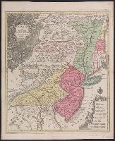
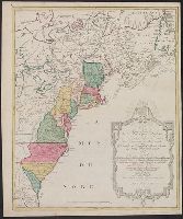
- Creator:
- Lotter, Tobias Conrad, 1717-1777
- Published / Created:
- 1760?]
- Call Number:
- 755 1760E
- Container / Volume:
- BRBL_00728
- Image Count:
- 1
- Resource Type:
- Maps, Atlases & Globes
- Description:
- Also covers New England (distorted) and
- Subject (Geographic):
- New England--Maps--Early works to 1800
- Found in:
- Beinecke Rare Book and Manuscript Library > Pensylvania, Nova Jersey et Nova York cum regionibus ad Fluvium Delaware in America sitis / nova delineatione ob oculos posita per Tob. Conr. Lotter, geographum Aug. Vind. ; Tob. Conr. Lotter sculps. Aug. V.
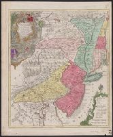
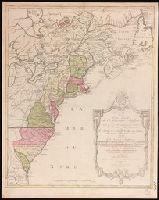
- Creator:
- Lotter, Tobias Conrad, 1717-1777
- Published / Created:
- 1760?]
- Call Number:
- 75 1730
- Container / Volume:
- BRBL_00689
- Image Count:
- 1
- Resource Type:
- Maps, Atlases & Globes
- Description:
- Also covers New England (distorted) and
- Subject (Geographic):
- New England--Maps--Early works to 1800
- Found in:
- Beinecke Rare Book and Manuscript Library > Pensylvania, Nova Jersey et Nova York cum regionibus ad Fluvium Delaware in America sitis / nova delineatione ob oculos posita per Tob. Conr. Lotter, geographum Aug. Vind. ; Tob. Conr. Lotter sculps. Aug. V.
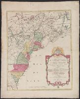
- Creator:
- Kitchin, Thomas, d. 1784
- Published / Created:
- 1778
- Call Number:
- 76 1778
- Container / Volume:
- BRBL_00690
- Image Count:
- 2
- Resource Type:
- Maps, Atlases & Globes
- Subject (Geographic):
- New England--Maps--Early works to 1800
- Found in:
- Beinecke Rare Book and Manuscript Library > A map of the colony of Rhode Island [cartographic material] : with the adjacent parts of Connecticut, Massachusetts Bay, & c / by Thos. Kitchin Senr., Hydrographer to His Majesty.
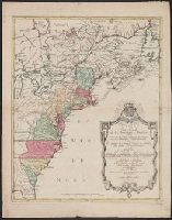
- Creator:
- Bowen, Emanuel, d. 1767
- Published / Created:
- 1754
- Call Number:
- 75 1720
- Container / Volume:
- BRBL_00689
- Image Count:
- 1
- Resource Type:
- Maps, Atlases & Globes
- Found in:
- Beinecke Rare Book and Manuscript Library > A map of the British American plantations [cartographic material] : extending from Boston in New England to Georgia, including all the back settlements in the respective provinces, as far as the Mississippi / by Eman. Bowen Geogr. to His Majesty ; Tho. Bo
- Creator:
- Lotter, Matthäus Albrecht, 1741-1810
- Published / Created:
- 1776?]
- Call Number:
- 755 1778D
- Container / Volume:
- BRBL_00432
- Image Count:
- 1
- Resource Type:
- Maps, Atlases & Globes
- Found in:
- Beinecke Rare Book and Manuscript Library > Carte nouvelle de l'Amérique angloise contenant tout ce que les Anglois possedent sur le continent de l'Amérique septentrionale savoir le Canada : la Nouvelle Ecosse ou Acadie, les treize provinces unies qui font : les quatres colonies de la Nouvelle An
- Creator:
- Lotter, Matthäus Albrecht, 1741-1810
- Published / Created:
- 1776?]
- Call Number:
- 755 1778
- Container / Volume:
- BRBL_00690
- Image Count:
- 1
- Resource Type:
- Maps, Atlases & Globes
- Found in:
- Beinecke Rare Book and Manuscript Library > Carte nouvelle de l'Amérique angloise contenant tout ce que les Anglois possedent sur le continent de l'Amérique septentrionale savoir le Canada : la Nouvelle Ecosse ou Acadie, les treize provinces unies qui font : les quatres colonies de la Nouvelle An
- Creator:
- Lotter, Matthäus Albrecht, 1741-1810
- Published / Created:
- 1776?]
- Call Number:
- 755 1776E
- Container / Volume:
- BRBL_00430
- Image Count:
- 1
- Resource Type:
- Maps, Atlases & Globes
- Found in:
- Beinecke Rare Book and Manuscript Library > Carte nouvelle de l'Amérique angloise contenant tout ce que les Anglois possedent sur le continent de l'Amérique septentrionale savoir le Canada : la Nouvelle Ecosse ou Acadie, les treize provinces unies qui font : les quatres colonies de la Nouvelle An
- Creator:
- Lotter, Matthäus Albrecht, 1741-1810
- Published / Created:
- 1776?]
- Call Number:
- 71 1776L
- Container / Volume:
- BRBL_00726
- Image Count:
- 1
- Resource Type:
- Maps, Atlases & Globes
- Found in:
- Beinecke Rare Book and Manuscript Library > Carte nouvelle de l'Amérique angloise contenant tout ce que les Anglois possedent sur le continent de l'Amérique septentrionale savoir le Canada : la Nouvelle Ecosse ou Acadie, les treize provinces unies qui font : les quatres colonies de la Nouvelle An
- Creator:
- Lotter, Matthäus Albrecht, 1741-1810.
- Published / Created:
- 1776?]
- Call Number:
- 755 1776E
- Image Count:
- 1
- Resource Type:
- Maps, Atlases & Globes
- Found in:
- Beinecke Rare Book and Manuscript Library > Carte nouvelle de l'Amérique angloise contenant tout ce que les Anglois possedent sur le continent de l'Amérique septentrionale savoir le Canada : la Nouvelle Ecosse ou Acadie, les treize provinces unies qui font : les quatres colonies de la Nouvelle Angleterre ... / gravée exactement d'après les determinations geographiques dernierement faites par Matthieu Albert Lotter.
- Published / Created:
- ca. 1747?]
- Call Number:
- 771 1760
- Container / Volume:
- BRBL_00690
- Image Count:
- 1
- Resource Type:
- Maps, Atlases & Globes
- Found in:
- Beinecke Rare Book and Manuscript Library > Map of Hudson's River, with the adjacent country [cartographic material].
- Published / Created:
- circa 1995-2017
- Call Number:
- VRC 1990a
- Image Count:
- 5
- Found in:
- Robert B. Haas Family Arts Library Special Collections > Garvin City Planning Image Collection (VRC 1990a) > U.S. Cities > KANSAS > Kansas City > NY Life Bldg. (MMW)
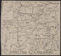
- Published / Created:
- 1917
- Call Number:
- 762gmb 1917
- Container / Volume:
- BRBL_00451
- Image Count:
- 1
- Resource Type:
- Maps, Atlases & Globes
- Description:
- Inset: Key map of New England showing
- Found in:
- Beinecke Rare Book and Manuscript Library > Through trails in the White Mountains : maintained by the organizations comprising the New England Trail Conference.
- Creator:
- From the Collection: Dunbar, Rudolph, 1899-1988
- Published / Created:
- 1978
- Call Number:
- JWJ MSS 174
- Container / Volume:
- Box 2, folder 48
- Image Count:
- 6
- Found in:
- Beinecke Rare Book and Manuscript Library > Rudolph Dunbar Papers (JWJ MSS 174) > Series II: Professional Papers > Periodical New England
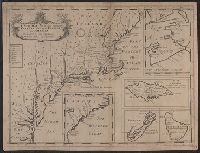
- Creator:
- Wells, Edward, 1667-1727
- Published / Created:
- 1722?]
- Call Number:
- 755 1722
- Container / Volume:
- BRBL_00425
- Image Count:
- 1
- Resource Type:
- Maps, Atlases & Globes
- Found in:
- Beinecke Rare Book and Manuscript Library > A new map of the most considerable plantations of the English in America : dedicated to His Highness William Duke of Glocester / Sutton Nichols sculp.
- Creator:
- Ely, William Watson
- Published / Created:
- 1878
- Call Number:
- 771 Ad47 1878
- Container / Volume:
- BRBL_00480
- Image Count:
- 1
- Resource Type:
- Maps, Atlases & Globes
- Description:
- Inset map of New York State and New
- Subject (Geographic):
- New England--Maps
- Found in:
- Beinecke Rare Book and Manuscript Library > Map of the New York Wilderness and the Adirondacks.
- Creator:
- Homann, Johann Baptist, 1663-1724
- Published / Created:
- 1759?]
- Call Number:
- 755 1759A
- Container / Volume:
- BRBL_00428
- Image Count:
- 1
- Resource Type:
- Maps, Atlases & Globes
- Description:
- Cf. McCorkle, B.B. New England in early
- Subject (Geographic):
- New England--Maps--Early works to 1800
- Found in:
- Beinecke Rare Book and Manuscript Library > Nova Anglia septentrionali Americae implantata Anglorumque coloniis florentissima geographice exhibita / [cartographic material] / a Ioh. Baptista Homann ...
- Creator:
- Overton, Henry, 1675 or 6-1751
- Published / Created:
- [1755?]
- Call Number:
- 755 1756F
- Container / Volume:
- BRBL_00428
- Image Count:
- 1
- Resource Type:
- Maps, Atlases & Globes
- Found in:
- Beinecke Rare Book and Manuscript Library > An accurate map of the British colonies in North America bordering on the river Ohio.
- Creator:
- Thornton, John, fl. 1652-1701
- Published / Created:
- [1673?]
- Call Number:
- 755 1682B
- Container / Volume:
- BRBL_00424
- Image Count:
- 1
- Resource Type:
- Maps, Atlases & Globes
- Alternative Title:
- , New-York & New England
- Description:
- Inset: "A mapp of New England".
- Subject (Geographic):
- New England--Maps--Early works to 1800
- Found in:
- Beinecke Rare Book and Manuscript Library > A mapp of Virginia, Mary-land, New-Jarsey, New-York, & New England.
- Creator:
- Morden, Robert, d. 1703
- Published / Created:
- [1676?]
- Call Number:
- 755 1675E
- Container / Volume:
- BRBL_00423
- Image Count:
- 1
- Resource Type:
- Maps, Atlases & Globes
- Alternative Title:
- Map of New England, New Yorke, New
- Subject (Geographic):
- New England--Maps--Early works to 1800
- Found in:
- Beinecke Rare Book and Manuscript Library > A map of New England, New Yorke, New Jersey, Mary-land & Virginia / Gr. King sculpsit.
- Creator:
- Speed, John, 1552?-1629
- Published / Created:
- [1676]
- Call Number:
- 755 1672A
- Container / Volume:
- BRBL_00423
- Image Count:
- 2
- Resource Type:
- Maps, Atlases & Globes
- Subject (Geographic):
- New England--Maps--Early works to 1800
- Found in:
- Beinecke Rare Book and Manuscript Library > A map of New England and New York / F. Lamb sculp.