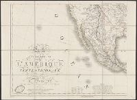
Search
You Searched For
Search Results
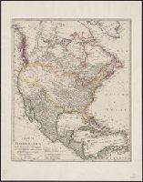
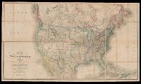
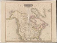
- Creator:
- Arrowsmith, Aaron, 1750-1823
- Published / Created:
- [betw. 1804 and 1811?]
- Call Number:
- 70 1808
- Container / Volume:
- BRBL_00358
- Image Count:
- 4
- Resource Type:
- Maps, Atlases & Globes
- Found in:
- Beinecke Rare Book and Manuscript Library > Map of America / by A. Arrowsmith ; engraved by W. West, the hills by H. Wilson.
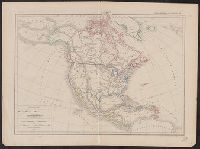
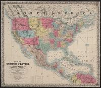
- Published / Created:
- 1906
- Call Number:
- 71 1906A
- Container / Volume:
- BRBL_00371
- Image Count:
- 2
- Resource Type:
- Maps, Atlases & Globes
- Subject (Topic):
- Geology--North America--Maps
- Found in:
- Beinecke Rare Book and Manuscript Library > Carte géologique de l'Amérique du nord / dressée d'apres les sources officielles des Etats Unis, du Canada, del la République du Mexique, de la Commission du Chemin de Fer Intercontinental, etc. ; Henry Ganett, géographe ; Bailey Willis, geologue.
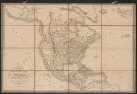
- Creator:
- Hall, Sidney
- Published / Created:
- [between 1825 and 1845]
- Call Number:
- BrSides 2018 137
- Image Count:
- 1
- Resource Type:
- Maps, Atlases & Globes
- Subject (Geographic):
- North America--Maps
- Subject (Topic):
- Indians of North America--Maps
- Found in:
- Beinecke Rare Book and Manuscript Library > North America / engraved by Sidney Hall.
- Published / Created:
- [1867?]
- Call Number:
- 826 1866
- Container / Volume:
- BRBL_00577
- Image Count:
- 1
- Resource Type:
- Maps, Atlases & Globes
- Subject (Topic):
- Indians of North America--Maps
- Found in:
- Beinecke Rare Book and Manuscript Library > Indian territory with part of the adjoining state of Kansas &c. / Engineer Bureau War Dept., October 1866.
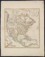
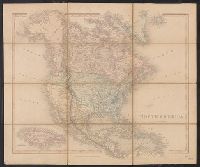
- Creator:
- Gallatin, Albert, 1761-1849
- Published / Created:
- [1836]
- Call Number:
- 71ed 1836
- Container / Volume:
- BRBL_00371
- Image Count:
- 1
- Resource Type:
- Maps, Atlases & Globes
- Subject (Topic):
- Indians of North America--Maps
- Found in:
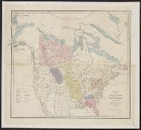
- Beinecke Rare Book and Manuscript Library > Map of the Indian tribes of North America, about 1600 A.D. along the Atlantic, & about 1800 A.D. westwardly / published by the Amer. Antiq. Soc. from a drawing by Hon. A. Gallatin.
- Creator:
- National Geographic Society (U.S.). Cartographic Division
- Published / Created:
- 1982
- Call Number:
- 7821 1982
- Container / Volume:
- BRBL_00506
- Image Count:
- 2
- Resource Type:
- Maps, Atlases & Globes
- Subject (Topic):
- Indians of North America--Maps
- Found in:
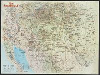
- Beinecke Rare Book and Manuscript Library > The Southwest / produced by the Cartographic Division, National Geographic Society ; John B. Garver, Jr., chief cartographer.
- Published / Created:
- 19--?]
- Call Number:
- 71ED 1850
- Container / Volume:
- BRBL_00371
- Image Count:
- 1
- Resource Type:
- Maps, Atlases & Globes
- Subject (Topic):
- Indians of North America--Maps
- Found in:
- Beinecke Rare Book and Manuscript Library > [Map of Indian tribes of North America].
- Creator:
- Powell, John Wesley, 1834-1902
- Published / Created:
- 1891]
- Call Number:
- 71ef 1890
- Container / Volume:
- BRBL_00371
- Image Count:
- 1
- Resource Type:
- Maps, Atlases & Globes
- Subject (Topic):
- Indians of North America--Maps
- Found in:
- Beinecke Rare Book and Manuscript Library > Linguistic stocks of American Indians north of Mexico / by J.W. Powell.
- Published / Created:
- 1756
- Call Number:
- 755 1756
- Container / Volume:
- BRBL_00428
- Image Count:
- 1
- Resource Type:
- Maps, Atlases & Globes
- Subject (Geographic):
- North America--Maps--Early works to
- Subject (Topic):
- British--North America--Maps--Early
- Found in:
- Beinecke Rare Book and Manuscript Library > Carte des possessions Françoises et Angloises dans le Canada, et partie de la Louisiane / L. Thevenard fil. sculp.
- Creator:
- Palairet, Jean, 1697-1774
- Published / Created:
- 1756
- Call Number:
- 755 1756D
- Container / Volume:
- BRBL_00428
- Image Count:
- 1
- Resource Type:
- Maps, Atlases & Globes
- Subject (Geographic):
- North America--Maps--Early works to
- Subject (Topic):
- British--North America--Maps--Early
- Found in:
- Beinecke Rare Book and Manuscript Library > Carte des possessions angloises & françoises du continent de l'Amérique septentrionale / par I. Palairet, Londres ; Thos. Kitchin, sculpt.
- Published / Created:
- 1756
- Call Number:
- 755 1756A
- Container / Volume:
- BRBL_00428
- Image Count:
- 1
- Resource Type:
- Maps, Atlases & Globes
- Subject (Geographic):
- North America--Maps--Early works to
- Subject (Topic):
- British--North America--Maps--Early
- Found in:
- Beinecke Rare Book and Manuscript Library > Carte du Canada et de la Louisiane qui forment la Nouvelle France et des colonies Angloises ou sont representez les pays contestez ... / par J. B. Nolin ...
- Published / Created:
- [1756?]
- Call Number:
- 755 1756C
- Container / Volume:
- BRBL_00428
- Image Count:
- 1
- Resource Type:
- Maps, Atlases & Globes
- Subject (Geographic):
- North America--Maps--Early works to
- Subject (Topic):
- British--North America--Maps--Early
- Found in:
- Beinecke Rare Book and Manuscript Library > The British & French dominions in North America : particularly shewing the French encroachments through all the British plantations from Nova Scotia down to the Gulf of Mexico.
- Creator:
- Arrowsmith, Aaron, 1750-1823
- Published / Created:
- [1818]
- Call Number:
- 71 1818A
- Container / Volume:
- BRBL_00368
- Image Count:
- 4
- Resource Type:
- Maps, Atlases & Globes
- Subject (Geographic):
- North America--Maps
- Found in:
- Beinecke Rare Book and Manuscript Library > A map exhibiting all the new discoveries in the interior parts of North America : inscribed by permission to the honourable governor and company of adventurers of England trading into Hudsons Bay in testimony of their liberal communications to their most
- Creator:
- L'Isle, Guillaume de, 1675-1726, cartographer.
- Published / Created:
- [1718]
- Call Number:
- BrSides Double Folio 2019 105
- Image Count:
- 1
- Resource Type:
- Maps, Atlases & Globes
- Subject (Geographic):
- North America--Maps.
- Found in:
- Beinecke Rare Book and Manuscript Library > America septentrionalis : concinnata juxta observationes D[omi]n[o] n[ostro] Academiae Regalis Scientiarum et nonnullorum aliorum, et juxta annotationes recentissimas / par G. De L'Isle, geographum.
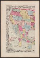
- Creator:
- Delamarche, Alexandre, 1815-1884, cartographer
- Call Number:
- 71 1838
- Container / Volume:
- BRBL_00370
- Image Count:
- 1
- Resource Type:
- Maps, Atlases & Globes
- Subject (Geographic):
- North America--Maps
- Found in:
- Beinecke Rare Book and Manuscript Library > Carte de l'Amerique Septentrionale / par Delamarche.
- Creator:
- Hennepin, Louis, 17th cent
- Published / Created:
- 19--?]
- Call Number:
- 71 1683
- Container / Volume:
- BRBL_00360
- Image Count:
- 1
- Resource Type:
- Maps, Atlases & Globes
- Subject (Geographic):
- North America--Maps
- Found in:
- Beinecke Rare Book and Manuscript Library > Carte de la Nouvelle France : et de la Louisiane nouvellement decouverte dediee au roy l'an 1683 / par le Reverend Pere Louis Hennepin, missionaire recollect et notaire apostoliquen ; N.Guerard ... et fecit.
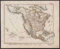
- Creator:
- Brué, A. (Adrien Hubert), 1786-1832
- Published / Created:
- [1818]
- Call Number:
- 71 1818
- Container / Volume:
- BRBL_00368
- Image Count:
- 4
- Resource Type:
- Maps, Atlases & Globes
- Subject (Geographic):
- North America--Maps
- Found in:
- Beinecke Rare Book and Manuscript Library > Carte encyprotype de l'Amerique Septentrionale : dediée et preśentée à Monsieur- / par H. Brué, ingénieur-géographe de S.A. Royale ; dirigé par Brue.́
- Creator:
- Dussieux, L. (Louis), 1815-1894, cartographer
- Call Number:
- 70 1865
- Container / Volume:
- BRBL_00359
- Image Count:
- 1
- Resource Type:
- Maps, Atlases & Globes
- Subject (Geographic):
- North America--Maps
- Found in:
- Beinecke Rare Book and Manuscript Library > Carte physique et politique de L'Amerique Septentrionale / par L. Dussieux, 1865.
- Creator:
- Brué, A. (Adrien Hubert), 1786-1832
- Published / Created:
- 1845
- Call Number:
- 71 1845B
- Container / Volume:
- BRBL_00370
- Image Count:
- 1
- Resource Type:
- Maps, Atlases & Globes
- Subject (Geographic):
- North America--Maps
- Found in:
- Beinecke Rare Book and Manuscript Library > Carte physique et politique de l'Amérique Septentrionale / par A.H. Brué, géographe du Roi.
- Creator:
- Brué, A. (Adrien Hubert), 1786-1832
- Published / Created:
- 1821
- Call Number:
- 71 1821
- Container / Volume:
- BRBL_00369
- Image Count:
- 1
- Resource Type:
- Maps, Atlases & Globes
- Subject (Geographic):
- North America--Maps
- Found in:
- Beinecke Rare Book and Manuscript Library > Carte physique et politique de l'Amérique septentrionale / par A.H. Brué, géographe de S.A.R. Monsieur.
- Creator:
- Reichard, C. G. (Christian Gottlieb), 1758-1837
- Published / Created:
- 1813
- Call Number:
- 71 1813
- Container / Volume:
- BRBL_00368
- Image Count:
- 1
- Resource Type:
- Maps, Atlases & Globes
- Subject (Geographic):
- North America--Maps
- Found in:
- Beinecke Rare Book and Manuscript Library > Charte von NordAmerica / entworfen und gezeichnet von C.G. Reichard.
- Creator:
- Reichard, C. G. (Christian Gottlieb), 1758-1837
- Published / Created:
- 1817
- Call Number:
- 71 1817
- Container / Volume:
- BRBL_00368
- Image Count:
- 1
- Resource Type:
- Maps, Atlases & Globes
- Subject (Geographic):
- North America--Maps
- Found in:
- Beinecke Rare Book and Manuscript Library > Charte von NordAmerica / entworfen und gezeichnet von C.G. Reichard.
- Creator:
- Walch, Johannes
- Published / Created:
- 1836
- Call Number:
- 71 1836
- Container / Volume:
- BRBL_00370
- Image Count:
- 1
- Resource Type:
- Maps, Atlases & Globes
- Subject (Geographic):
- North America--Maps
- Found in:
- Beinecke Rare Book and Manuscript Library > Charte von Nordamerica : nach den neuesten Entdeckungen und zuverläfsigsten astronomischen Ortsbestimmungen entworfen / bey Joh: Walch.
- Creator:
- Johnson and Ward
- Published / Created:
- 1866?]
- Call Number:
- 71 1866
- Container / Volume:
- BRBL_00371
- Image Count:
- 2
- Resource Type:
- Maps, Atlases & Globes
- Subject (Geographic):
- North America--Maps
- Found in:
- Beinecke Rare Book and Manuscript Library > Johnson's North America / by Johnson and Ward.
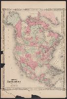
- Creator:
- Smith, J. Calvin (John Calvin)
- Published / Created:
- 1849
- Call Number:
- 71 1849A
- Container / Volume:
- BRBL_00370
- Image Count:
- 1
- Resource Type:
- Maps, Atlases & Globes
- Subject (Geographic):
- North America--Maps
- Found in:
- Beinecke Rare Book and Manuscript Library > Map of North America / by J. Calvin Smith.
- Creator:
- Smith, J. Calvin (John Calvin)
- Published / Created:
- 1850
- Call Number:
- 71 1850A
- Container / Volume:
- BRBL_00370
- Image Count:
- 1
- Resource Type:
- Maps, Atlases & Globes
- Subject (Geographic):
- North America--Maps
- Found in:
- Beinecke Rare Book and Manuscript Library > Map of North America / by J. Calvin Smith.
- Creator:
- Smith, J. Calvin (John Calvin)
- Published / Created:
- 1851
- Call Number:
- 71 1851A
- Container / Volume:
- BRBL_00370
- Image Count:
- 1
- Resource Type:
- Maps, Atlases & Globes
- Subject (Geographic):
- North America--Maps
- Found in:
- Beinecke Rare Book and Manuscript Library > Map of North America / by J. Calvin Smith.
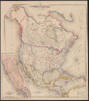
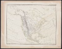
- Creator:
- Wyld, James, 1812-1887
- Published / Created:
- [1854?]
- Call Number:
- 71 1854A
- Container / Volume:
- BRBL_00371
- Image Count:
- 1
- Resource Type:
- Maps, Atlases & Globes
- Subject (Geographic):
- North America--Maps
- Found in:
- Beinecke Rare Book and Manuscript Library > Map of North America : exhibiting the recent discoveries, geographical & nautical / by James Wyld, Geographer to Her Majesty ; J.W. del. ; Stockley fc.
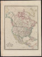
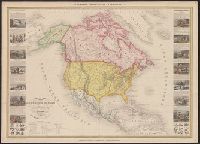
- Creator:
- Wyld, James, 1812-1887
- Published / Created:
- [1828]
- Call Number:
- 71 1828
- Container / Volume:
- BRBL_00369
- Image Count:
- 7
- Resource Type:
- Maps, Atlases & Globes
- Subject (Geographic):
- North America--Maps
- Found in:
- Beinecke Rare Book and Manuscript Library > Map of North America : exhibiting the recent discoveries, geographical and nautical; drawn chiefly from the authorities of M. de Humbolt, Lieutt. Pike, Messrs. Lewis and Clarke, Sir Alexr. Mackenzie, Mr. Hearne, Coll. Bouchette, Captns. Vancouver, Ross, P
- Creator:
- Wyld, James, 1812-1887
- Published / Created:
- [187-?]
- Call Number:
- 71 1870A
- Container / Volume:
- BRBL_00371
- Image Count:
- 1
- Resource Type:
- Maps, Atlases & Globes
- Subject (Geographic):
- North America--Maps
- Found in:
- Beinecke Rare Book and Manuscript Library > Map of North America : exhibiting the recent discoveries, geographical and nautical; drawn chiefly from the authorities of M. de Humbolt, Lieutt. Pike, Messrs. Lewis and Clarke, Sir Alexr. Mackenzie, Mr. Hearne, Coll. Bouchette, Captns. Vancouver, Ross, P
- Creator:
- Geological Survey (U.S.)
- Published / Created:
- 1912
- Call Number:
- 71 1912
- Container / Volume:
- BRBL_00371
- Image Count:
- 1
- Resource Type:
- Maps, Atlases & Globes
- Subject (Geographic):
- North America--Maps
- Found in:
- Beinecke Rare Book and Manuscript Library > Map of North America : reduced from map on scale of 1:5,000,000 / compiled by the U.S. Geological Survey.
- Creator:
- National Railway Publication Company
- Call Number:
- BrSides Zc19 N82h 870na
- Image Count:
- 1
- Resource Type:
- Maps, Atlases & Globes
- Subject (Geographic):
- North America--Maps.
- Found in:
- Beinecke Rare Book and Manuscript Library > Map of the Northern Pacific Railway and tributary country.
- Creator:
- Colton, G. Woolworth (George Woolworth), 1827-1901
- Published / Created:
- 1854
- Call Number:
- 71 1854B
- Container / Volume:
- BRBL_00371
- Image Count:
- 2
- Resource Type:
- Maps, Atlases & Globes
- Subject (Geographic):
- North America--Maps
- Found in:
- Beinecke Rare Book and Manuscript Library > Map of the United States of America, the British provinces, Mexico, the West Indies, and Central America, with part of New Granada and Venezuela / map drawn by Geo. W. Colton ; engraved by John M. Atwood ; border desig'd. & eng'd. by W.S. Barnard.
- Creator:
- Atwood, John M., b. ca. 1818
- Published / Created:
- 1851
- Call Number:
- 75 1851B
- Container / Volume:
- BRBL_00400
- Image Count:
- 1
- Resource Type:
- Maps, Atlases & Globes
- Subject (Geographic):
- North America--Maps
- Found in:
- Beinecke Rare Book and Manuscript Library > Map of the United States, Canada, Mexico, Central America, and the West India Islands : with a portion of Venezuela & New Granada; showing the routes overland and by the Isthmus to California & Oregon, also the new boundaries of California, Utah, & New Me
- Creator:
- Stieler, Adolf, 1775-1836
- Published / Created:
- 1835?]
- Call Number:
- 71 1835
- Container / Volume:
- BRBL_00370
- Image Count:
- 1
- Resource Type:
- Maps, Atlases & Globes
- Subject (Geographic):
- North America--Maps
- Found in:
- Beinecke Rare Book and Manuscript Library > Nord America / entworfen u. gezeichnet von F. v. St. 1832 ; L. Thiel sc.
- Creator:
- Weiland, C. F. (Carl Ferdinand), -1847, cartographer
- Published / Created:
- 1833
- Call Number:
- 71 1833
- Container / Volume:
- BRBL_00369
- Image Count:
- 1
- Resource Type:
- Maps, Atlases & Globes
- Subject (Geographic):
- North America--Maps
- Found in:
- Beinecke Rare Book and Manuscript Library > Nord America / entworfen und gezeichnet von C.F. Weiland ; Gest. v. C. Jungmann, W. 30.
- Creator:
- Wilkinson, Robert, -approximately 1825
- Published / Created:
- 1823 August 12
- Call Number:
- 71 1823
- Container / Volume:
- BRBL_00369
- Image Count:
- 1
- Resource Type:
- Maps, Atlases & Globes
- Subject (Geographic):
- North America--Maps
- Found in:
- Beinecke Rare Book and Manuscript Library > North America / E. Bourne sculp.
- Creator:
- Thomson, John, geographer
- Published / Created:
- 1814
- Call Number:
- 71 1814
- Container / Volume:
- BRBL_00368
- Image Count:
- 1
- Resource Type:
- Maps, Atlases & Globes
- Subject (Geographic):
- North America--Maps
- Found in:
- Beinecke Rare Book and Manuscript Library > North America / N.R. Hewitt, sc.
- Creator:
- Betts, John, fl. 1844-1863
- Published / Created:
- [18--?]
- Call Number:
- 71 18XX
- Container / Volume:
- BRBL_00371
- Image Count:
- 2
- Resource Type:
- Maps, Atlases & Globes
- Subject (Geographic):
- North America--Maps
- Found in:
- Beinecke Rare Book and Manuscript Library > North America.
- Creator:
- Vuillemin, A. (Alexandre), 1812-
- Published / Created:
- [1855?]
- Call Number:
- 71 1855C
- Container / Volume:
- BRBL_00371
- Image Count:
- 1
- Resource Type:
- Maps, Atlases & Globes
- Subject (Geographic):
- North America--Maps
- Found in:
- Beinecke Rare Book and Manuscript Library > Nouvelle carte illustrée de l'Amérique du nord : indiquant les grandes divisions physiques, la distribution géographique des végétaux et des minéraux, les ports de commerce, villes industrielles en fortifiées / dressée par A. Vuillemin, géographe
- Creator:
- Platt, Albert, 1794-1862
- Published / Created:
- 184-?]
- Call Number:
- 71CB 1840A
- Container / Volume:
- BRBL_00371
- Image Count:
- 1
- Resource Type:
- Maps, Atlases & Globes
- Subject (Geographic):
- North America--Maps
- Found in:
- Beinecke Rare Book and Manuscript Library > Oro-und hydrographische Karte v. Nordamerica.
- Creator:
- Wyld, James, 1812-1887
- Published / Created:
- March 2nd 1857.
- Call Number:
- 71 1857
- Container / Volume:
- BRBL_00371
- Image Count:
- 2
- Resource Type:
- Maps, Atlases & Globes
- Subject (Geographic):
- North America--Maps
- Found in:
- Beinecke Rare Book and Manuscript Library > The British possessions in North America and the United States with the Hudson's Bay territories / by James Wyld, geographer to the Queen & H.R.H. Prince Albert.
- Creator:
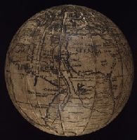
- Holbein, Hans, 1497-1543. Ambassadors
Schöner, Johann, 1477-1547
- Published / Created:
- ca. 1885?]
- Call Number:
- 2003 1481
- Image Count:
- 9
- Resource Type:
- Maps, Atlases & Globes
- Subject (Geographic):
- North America--Maps
- Found in:
- Beinecke Rare Book and Manuscript Library > ["The Ambassadors" globe]
- Creator:
- Coronelli, Vincenzo, 1650-1718
- Published / Created:
- 1688
- Call Number:
- 755 1688
- Container / Volume:
- BRBL_00424
- Image Count:
- 1
- Resource Type:
- Maps, Atlases & Globes
- Subject (Geographic):
- Great Lakes Region (North America
- Subject (Topic):
- Indians of North America--Maps--Early
- Found in:
- Beinecke Rare Book and Manuscript Library > Partie occidentale du Canada, ou de la Nouvelle France : ou sont les nations des Ilinois, de Tracy, les Iroquois, et plusieurs autres peuples; avec la Louisiane nouvellement decouverte etc. Dressée sur les memoires les plus nouveaux / par le P. Coronelli
- Creator:
- Kitchin, Thomas, d. 1784
- Published / Created:
- 1766?]
- Call Number:
- 755 1763A
- Container / Volume:
- BRBL_00428
- Image Count:
- 1
- Resource Type:
- Maps, Atlases & Globes
- Subject (Geographic):
- North America--Maps--Early works to
- Subject (Topic):
- British--North America--Maps--Early
- Found in:
- Beinecke Rare Book and Manuscript Library > A new and accurate map of the British dominions in America, according to the Treaty of 1763, divided into the several provinces and jurisdictions : projected upon the best authorities and astronomical observations / by Thos. Kitchin, geographer.
- Creator:
- Hendges, M
- Published / Created:
- 1904
- Call Number:
- 70gme 1904
- Container / Volume:
- BRBL_00359
- Image Count:
- 1
- Resource Type:
- Maps, Atlases & Globes
- Subject (Topic):
- Railroads--North America--Maps
- Found in:
- Beinecke Rare Book and Manuscript Library > Intercontinental railway map : prepared under the direction of the permanent Pan American Railway Committee authorized by the Second International Conference of American States / M. Hendges.
- Creator:
- Steiger, W. T
- Published / Created:
- 1854
- Call Number:
- 75gme 1854
- Container / Volume:
- BRBL_00411
- Image Count:
- 2
- Resource Type:
- Maps, Atlases & Globes
- Subject (Topic):
- Railroads--North America--Maps
- Found in:
- Beinecke Rare Book and Manuscript Library > Diagram of the United States of America, Mexico, the West India Islands and Isthmus of Darien : showing proposed routes of the Pacific Rail Road ... / by W. T. Steiger, General Land Office ; Lith. by A. Hoen & Co. Baltimore.
- Creator:
- Kitchin, Thomas, d. 1784
- Published / Created:
- 1780?]
- Call Number:
- 755 1760
- Container / Volume:
- BRBL_00428
- Image Count:
- 1
- Resource Type:
- Maps, Atlases & Globes
- Subject (Geographic):
- North America--Maps--Early works to
- Subject (Topic):
- Indians of North America--Maps--Early
- Found in:
- Beinecke Rare Book and Manuscript Library > British dominions in America : drawn from the latest and best authorities / by Thos. Kitchin, hydrographer to his majesty.
- Creator:
- Gibson, J. (John)
- Published / Created:
- 1763]
- Call Number:
- 75 1778
- Collection Title:
- Gentleman's magazine.
- Container / Volume:
- BRBL_00689
- Image Count:
- 1
- Resource Type:
- Maps, Atlases & Globes
- Subject (Geographic):
- North America--Maps--Early works to
- Subject (Topic):
- Indians of North America--Maps--Early
- Found in:
- Beinecke Rare Book and Manuscript Library > [Map of Louisiana and the western parts of Virginia and Carolina] / [cartographic material] / J. Gibson, sculp.
- Creator:
- G.W. & C.B. Colton & Co
- Published / Created:
- 1870
- Call Number:
- 80 1870
- Container / Volume:
- BRBL_00535
- Image Count:
- 1
- Resource Type:
- Maps, Atlases & Globes
- Subject (Topic):
- Indians of North America--Maps
- Found in:
- Beinecke Rare Book and Manuscript Library > Colton's map of the states and territories west of the Mississippi River to the Pacific Ocean : showing the overland routes, projected rail road lines, &c.