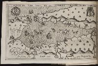
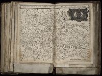
Histoire de la Nouvelle-France : contenant les navigations, decouvertes, & habitations faites par
Image Count:
1
Description:
Bound in after p. 496., In pencil in upper left corner: 497., Map has three or four small brown marks on verso, the largest of which is on the right margin., and Scale not given.
Subject (Geographic):
America --Discovery and exploration --French --Early works to 1800, New France --Discovery and exploration --Early works to 1800, and New France --Maps --Early works to 1800
Subject (Name):
Millot, Jean, b. 1582, printer, Swelinck, Jan, engraver, and Villegaignon, Nicolas Durand de, 1510-1571?
Broeck, Crispin van den, 1524-ca. 1591 Visscher, Nicolaes, 1618-1679
Published / Created:
[ca. 1660]
Call Number:
1983 Folio 19
Collection Title:
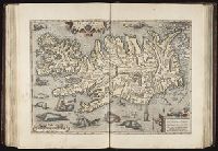
[Atlas factice of 96 maps by Blaeu, Visscher, Jansson, Hondius and others]
Image Count:
2
Alternative Title:
Armenia Maior and Asia et Armenia Minor
Description:
Imperfect: illustrations at top cut-out and replaced with ms. titles "Asia et Armenia minor" (upper left) and "Armenia minor" (in upper right); torn along fold and at left edge, with some loss of text. Sheet measures 32 x 47.8 cm. Reinforced along edges with printed waste. No. 85 of 92 maps bound together. and Numbered 91 on verso.
Publisher:
[Nicolaes Visscher]
Subject (Geographic):
Armenia --Maps --Early works to 1800, Assyria --Maps, Egypt --Maps --Early works to 1800, Middle east --Maps --Early works to 1800, Palestine --Geography --Maps --Early works to 1800, Saudi Arabia --Maps, Syria --Maps, and Turkey --Maps
Mecometrie de leymant, cest a dire La maniere de mesvrer les longitudes par le moyen de l’eymant
Image Count:
1
Description:
Bound in preceding t.p. for pt. [2] (Premier livre de la Mecometrie arithmetique de l’eymant)., Imperfect: map rubbed, with some loss of map and text., Map has small tear on left edge at gutter., and Scale [ca. 1:100,000,000].
Subject (Topic):
Longitude --Early works to 1800 and World maps --Early works to 1800
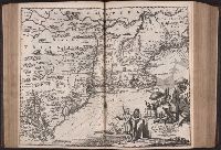
[Atlas factice of 96 maps by Blaeu, Visscher, Jansson, Hondius and others]
Image Count:
2
Description:
Imperfect: cartouche cut-out and replaced in ms. Sheet measures 38.1 x 49.3 cm. Reinforced along edges with printed waste. No. 84 of 92 maps bound together. and Numbered 90 on verso.
Publisher:
Apud Guiljelmum Blaeu
Subject (Geographic):
Salzburg (Austria : Land) --Maps --Early works to 1800
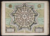
Speculum geographicum totivs Germaniae repraesentans. and Speculum orbis terrarum
Description:
Foliation: 2 unnumbered bifolia, XXVII bifolia, 1 bifolium, XXXVIII bifolia, 1 unnumbered bifolium., Imperfect: wormed, with no loss of text; holes in map "Universi orbis seu terreni globi ..." Misbound: gatherings x-y bound after gathering z. No. 148 in H. C. Taylor coll., Imprint from colophon., Ninety maps on 65 sheets; text on verso of maps., Part 2 has title: Speculum geographicum totius Germaniae Imperium repraesentans., Signatures: pi² 2pi² a-c² [superscript chi]c² d-s² v-z² [superscript chi]Z² 2a-2c² [2d]², [superscript chi]A² A-2P² [2Q]² (2Q2 blank; signatures [superscript chi]A and A are signed 'A2')., and With dedication on verso of title page, dated 1578.
Publisher:
de Catelyne Vesten, ad intersigne Floreni aurati, in aedibus Gerardi de Iode, typis Gerardi Smits,
Descriptio ac delineatio geographica detectionis freti, sive, transitus ad occasum supra terras
Image Count:
1
Abstract:
Map depicts the Coat of Arms of the United Kingdom (era of the Union of the Crowns), reigning between the years 1603-1707.
Alternative Title:
Tabula nautica, qua repraesentantur orae maritimae, meatus, ac freta, noviter a H. Hudsono Anglo ad Caurum supra Novam Franciam
Description:
Bound in after p. [2]., In pencil on recto: 170., Map cut and folded irregularly., Map has multiple small stains on both the recto and verso., and Scale [ca. 1:9,000,000].